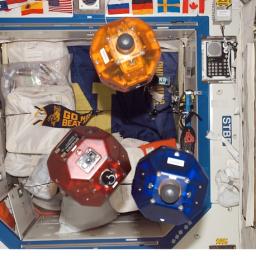
Since 2006, three bowling ball-size free-flying Synchronized Position Hold, Engage, Reorient, Experimental Satellites (SPHERES) have been floating around the International Space Station. Now, they are
attaching a smartphone to the spheres, making them "Smart SPHERES", a more "intelligent" free-flying robot with built-in cameras to take pictures and video, sensors to help conduct inspections, powerful computing units to make calculations and Wi-Fi connections to transfer data in real time to the computers aboard the space station and at mission control in Houston.
In a two-phase experiment, astronauts will manually use the smartphones to collect visual data using the integrated custom 3-D sensor to generate a full 3-D model of their environment. After the map and its coordinate system are developed, a second activity will involve the smartphones attached to the SPHERES, becoming the free-flying Smart SPHERES. As the free-flying robots move around the space station from waypoint to waypoint, utilizing the 3-D map, they will provide situational awareness to crewmembers inside the station and flight controllers in mission control. These experiments allow NASA to test vision-based navigation in a very small mobile product.
"NASA uses robots for research and mission operations; just think about the rovers on Mars or the robotic arm on the ISS or space shuttle," said Chris Provencher, manager of the Smart SPHERES project. "Inside the ISS space is limited, so it's really exciting to see technology has advanced enough for us to demonstrate the use of small, mobile robots to enhance future exploration missions."
Ultimately it is the hope of researchers that these devices will perform housekeeping-type tasks, such as video surveys for safety and configuration audits, noise level measurements, air flow measurements, and air quality measurements, that will offset work the astronauts currently perform.