 |
by Terry Miller on (#27D84)
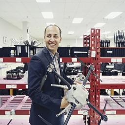
Unmanned Risk Management is a wholly owned subsidiary and dba of Transport Risk Management, Inc. (Transport Risk) that focuses on the marketing, development and placement of unmanned insurance products on behalf of Transport Risk and its clients. Transport Risk is an independent specialty aviation insurance brokerage firm based in Colorado, USA. All of Transport Risk’s […]
|
sUAS News
| Link | https://www.suasnews.com/ |
| Feed | http://www.suasnews.com/feed |
| Updated | 2026-07-19 08:00 |
 |
by Tiaan Roux on (#27C4Z)
|
 |
by Press on (#27BYC)
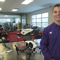
The National Institute of Food and Agriculture (NIFA) has awarded $975,000 to Kansas State University for work that incorporates unmanned aerial vehicles in the process of breeding better wheat varieties. The university’s work is designed to give scientists deeper understanding of in-field conditions so they can improve breeding programs in the United States and internationally. […]
|
 |
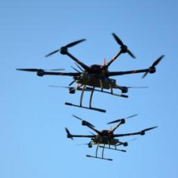
by Gary Mortimer on (#27BJ3)
Drones in a box biding their time waiting to do their masters bidding. This is a market I see a bright future for. Why does a mine or building site need to call up a trained pilot to fly the same route day in day out? Rather have the drone do it and then tuck […]
|
 |
by Gary Mortimer on (#27BEQ)
A delivery flight tasked from 40km away!. The drone was summoned by the Major of Chiba City, Toshihito Kumagai, via a cell phone app. The Sora Raku drone from Japanese company Rakuten flew from their Crimson House headquarters to Inage Kahin Park Pool. This delivery has put Amazon’s recent efforts into the spotlight again. Perhaps to […]
|
 |
by Press on (#275NT)
BirdsEyeView Aerobotics is a startup company that designs and manufactures small unmanned aircraft systems (www.birdseyeview.aero). Our goal is to make flying robots accessible to everyday people in everyday environments. We are looking for a Senior Software Developer with a strong work ethic and a passion for developing cutting edge technology to join our team in […]
|
 |
by Gary Mortimer on (#273NW)
I’m not a lawyer, obviously, and will get Loretta and Jonathan to explain very slowly to me what this means. As I layman I conclude that Khang and Khang think GoPro investors were sold a pup. Khang & Khang LLP (the “Firmâ€) announces a class action lawsuit against GoPro, Inc. (“GoPro†or the “Companyâ€) (NASDAQ: […]
|
 |
by Brandi Jewett on (#2727K)
GRAND FORKS, N.D. — SkySkopes, a national leader in unmanned aircraft system flight operations, has established a training academy at the University of North Dakota Center for Innovation. The academy is geared toward anyone with a desire to learn more about unmanned aircraft and the overall industry, whether they are currently a hobbyist or an […]
|
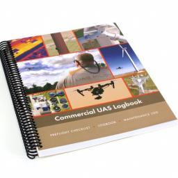 |
by Press on (#2725P)
Kenosha, WI — In response to the recent FAA regulations for preflight inspections and recordkeeping, Aeroworks has released a professionally designed and printed Commercial UAS Logbook. The Logbook includes a detailed flight checklist, 100 flight specific logbook pages, maintenance log and camera focus card. The book features a heavy-duty spiral binding that opens completely for […]
|
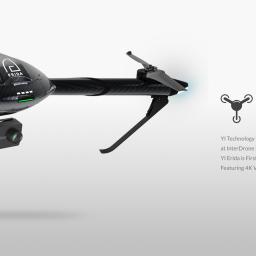 |
by Press on (#271BT)
It is that time of year again, CES press releases are landing. We hear again about the former crowd funder tricopter. “2016 has been a whirlwind of product launches including several new action and home security cameras, the YI Erida drone, our first mirrorless camera the YI M1, as well as an exciting partnership with […]
|
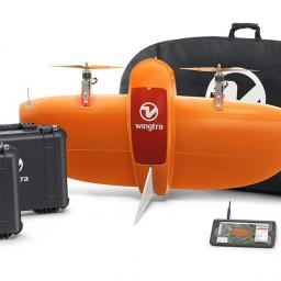 |
by Gary Mortimer on (#26Y87)
I notice that the very attractive looking Wingtra VTOL has undergone a slight design change. The often used aviation sore, if it looks right it will fly right, I should imagine applies. A touch of the clipped wing Spitfire in the new shape. Not seeing much of it in the open market, though. It deserves to […]
|
 |
by Press on (#26Y9E)
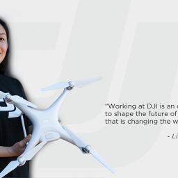
As DJI is growing rapidly in the US market, we are looking for an experienced HR Generalist in our Carson, CA offices to support our ongoing expansion. We plan to double our headcount in the US market in the next 12-18 months. Responsibilities: -Communicates intensively with the global HR team in DJI headquarters in Shenzhen, […]
|
 |
by Gary Mortimer on (#26XRN)
Decisions decisions, which drone should I buy? Sydney-based cloud GIS service provider, PropellerAero, have released the first of a new series of white papers helping you choose. A stand out sensible line for me is this one: “The type of airspace your site sits within will determine whether you can purchase a drone yourself or […]
|
 |
by Gary Mortimer on (#26XMV)
Delivery of medical or humanitarian supplies is perhaps the only delivery drone use-case that makes sense. Well done to Zipline then for securing another trial. The UK Government’s Department for International Development (DFID) is to fund the next trial in Tanzania. A DFID spokeswoman told the BBC: “Flights are planned to start in early 2017, […]
|
 |
by Press on (#26W5S)
Dr Joseph Davis, Captain, USMC (RET), Remote Pilot and Partner for Davion LLC Visit? What visits and when? Part 107.7 discusses the inspection, testing, and demonstration of compliance with FAA regulations with regard to UAS. When are they coming? Good question! Now is the time to get ready—but if you are doing what is required […]
|
 |
by Gary Mortimer on (#26VD8)
A major announcement out of North Dakota today marks a leap forward for the advancing commercial drone industry. The state’s Northern Plains UAS Test Site (NPUAST) received permission from the Federal Aviation Administration to conduct beyond-visual-line-of-sight flights from the Grand Forks, N.D., area. It’s the first certificate of authorization awarded to a test site and […]
|
 |
by Press on (#26V1M)
WASHINGTON – Senator John Hoeven today announced that the Federal Aviation Administration (FAA) has approved a certificate of authorization (COA) for the Northern Plains UAS Test Site to oversee unmanned aircraft operations that go beyond the line of sight of the operator. The senator worked to secure approval of this request from the FAA. The […]
|
 |
by Press on (#26TX3)
With Unmanned Aerial Vehicles (UAVs) or drones gaining popularity globally for commercial, recreational and industry purposes, hundreds of UAVs may soon be buzzing all over Singapore. The lower cost of drones and rising demand for commercial drone services have already led to a boom in the number of drones taking to the skies in Singapore. […]
|
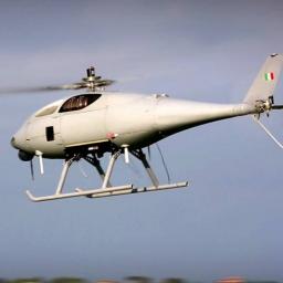 |
by Gary Mortimer on (#26THS)
In a move to consolidate its unmanned helicopter offerings, Leonardo has bought the remaining 60% share of Sistemi Dinamici. In the process creating another acronym RUAS – Rotorcraft Unmanned Aerial System, a bit of a dodgy one this as it would apply to multi-copters as well. Mauro Moretti, CEO and General Manager of Leonardo said: “This […]
|
 |
by Gary Mortimer on (#26TEP)
Last night in Drone Stuff this week we discussed crop spraying from drones and not 24 hours later a video pops up showing the sort of precision terrain following required to dust. UAVenture has been testing the uLanding microwave altimeter. uLanding is a (60g), sealed distance sensor with a 30m range and 500Hz update rate. […]
|
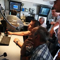
by Gary Mortimer on (#26SXZ)
The one in which Colin Snow shares market insights, and believes we have not reached peak drone. Rory Paul talks more Agriculture, and large platforms. Matt from SkySkopes informs us on 107 training and what is happening in North Dakota. Including mention of BVLOS and crop spraying from RPAS. Gene has some huge motors to […]
 |
by Press on (#26SVQ)
DroneDeploy is the leading cloud software platform for commercial drones, making the power of aerial data accessible and productive for everyone. Trusted by businesses and individuals in over 130 countries worldwide, we are transforming the way drone users collect, manage and digest impactful data in a variety of industries, including agriculture, real estate, mining and […]
|
 |
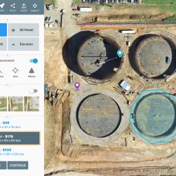
by Gary Mortimer on (#26SVR)
3DR, an Autodesk portfolio company, makes advanced commercial drone technology for data analysis, mapping and 3D modelling in the construction, mining and surveying industries. 3DR’s flagship enterprise product is Site Scan, a complete camera-to-the-cloud drone system. For more information, please visit 3DR.com. 3DR makes advanced drone technology easily accessible to the construction, mining and surveying […]
|
 |
by Gary Mortimer on (#26Q4K)
UAVenture has unveiled a feature that will be popular with the drone delivery crowd. Their AirRails flight controller can detect a stall whilst in flight, and catch it if you will. Saving the airframe with the multirotor component. A useful trait in something that might be flying over populated areas at the time. AirRails is […]
|
 |
by Press on (#26PQB)
YellowScan designs, develops and produces aerial drone imaging sensor systems for professional applications. Fully integrated, ultra-light and easy to use, these highly automated data collection tools are employed by customers around the world in fields such as surveying, forestry, environmental research archaeology, industrial inspection, civil engineering and mining. To rapidly develop the activity all around […]
|
 |
by Press on (#26PQD)
(BelTA) – Belarus and China are busy setting up a joint venture to make unmanned aerial vehicles (UAV), BelTA learned from First Deputy Chairman of the Presidium of the National Academy of Sciences of Belarus Sergei Chizhik during the press conference held on 26 December to discuss the Year of Science in Belarus. According to […]
|
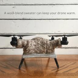 |
by Gary Mortimer on (#26P5H)
Oh, why oh why did I not see this before Christmas. Artist Danielle Baskin has created sweaters for drones! “Once you have decided to get a sweater for your drone, you will need to begin by considering material. While wool is very warm and one of the best insulating materials, take into account how often it […]
|
 |
by Gary Mortimer on (#26H3F)
Experts expect ‘peak lost drone’ to occur in the next eight hours. America is beginning to wake up and presents will open and batteries start to charge. Google trends show that Europe has led the way. I will offer a couple of bits of advice for first timers. It is a jolly exciting thing that […]
|
 |
by Gary Mortimer on (#26EDW)
Readers in New Zealand have beaten the rest of us to it, a shout out to Bruce and Ron. The rest of us are about to start. Twenty seventeen is going to be an interesting year. The first post-Part 107 growing season in the USA. Precision Agriculture is really going to have to prove itself. […]
|
 |
by Gary Mortimer on (#26E3K)
Another new acronym ESTOL, yes that is Electric Short Take-Off and Landing. Two new renderings from Israeli company the Advanced Programs Group, some big platforms. Rhino (above), has a maximum take-off weight of 70kg, a wingspan of 10m, maximum ceiling of 15,000ft. Renegade has a wingspan of 4.4m (14.4ft), and can take off from a […]
|
 |
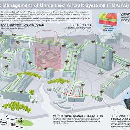
by Press on (#26DZC)
Building on its strengths of innovation, collaboration and safety, Unmanned Experts partners with Aeryon Labs Inc., the NASA Ames Research Center and other industry stakeholders in the development and testing of an Unmanned Aircraft System Traffic Management (UTM) System. The UTM System, being developed under a NASA partnership program, would enable safe and efficient low-altitude […]
|
 |
by Press on (#26DY0)
Drone Aviation Holding Corp, a leading provider of tethered drones and lighter-than-air aerostats, today announced the appointment of Bruce R.C. Hardy as its new Vice President of Sales. Mr. Hardy is a former U.S. Navy Seal with over 20 years of military service and a decade of sales experience selling hardware and software to the […]
|
 |
by Press on (#26AFD)
Researchers from the U.S. Naval Research Laboratory’s chemistry and tactical electronic warfare divisions completed the first flight of the Ion Tiger unmanned air vehicle with a new hydrogen-powered fuel cell built in-house. The NRL team designed and built a custom fuel cell system capable of up to 5,000 watts, using formed metal-foil bipolar plates, which […]
|
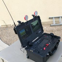 |
by Press on (#26AE4)
A 12 channel ground station integrated into the Pelican© 1510 field case with retractable luggage handle. Internal computer with panel mounted keyboard and mouse. Dual 10.4″ sunlight viewable LCD screens. Retractable 3-axis flight control stick, 2-axis camera gimbal stick, precision throttle slide, and custom on-screen display makes for a revolutionary flight control system. PNP (Plug and […]
|
 |
by Press on (#269MZ)
This position is for a Technical Marketing Engineer within the Intel Drone Team. The job requirements include the ability to maintain and develop the technical relationship with our key partners in North America. The successful applicant will be able to work independently with existing and new customers on every aspect of the technical relationship: software, […]
|
 |
by Press on (#268DA)
Embry-Riddle Worldwide offers MOOCs (Massive Open Online Course) to anyone with an Internet connection and a desire to learn about aviation. And they are free! The course, “Small Unmanned Aircraft Systems (sUAS) – Key Concepts for New Users,†runs from Feb. 6 to Feb. 19. Registration starts January 9, 2017. Small Unmanned Aircraft Systems (sUAS) […]
|
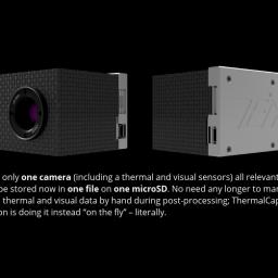 |
by Press on (#267W6)
The bar has been raised up by TeAx Technology – again: Today, the company is publicly announcing its latest product ThermalCapture Fusion, a powerful and perfectly aligned dual camera solution to store both, thermal and visual data from its sensors. ThermalCapture Fusion: The new standard in the thermal drone industry. Finally, an independent and lightweight […]
|
 |
by Press on (#267M8)
Over the last year, the Federal Aviation Administration (FAA) has made great strides toward integrating unmanned aircraft – popularly called “drones†– into the nation’s airspace. The first big step took place last December 21, when a new, web-based drone registration system went online. During the last year, the system has registered more than 616,000 […]
|
 |
by Press on (#267MA)
A testing program combining newly developed telecommunications network and MMC’s hydrogen fueled drone series was in trial in MMC’s R&D centre in Shenzhen, China earlier this month. The upcoming innovative creation is aimed to develop industrial drone solutions with a potential endurance of up to 8 hours and potential range of hundreds of kilometres. While commercial […]
|
 |
by Tiaan Roux on (#266ZK)
As part of Transport Canada’s drone safety initiatives, the department has launched a new reporting tool on their website, where the public can report unsafe drone flying. This form does not replace any official incident reporting system, such as the Civil Aviation Daily Occurrence Reporting System but is meant to be a more direct reporting channel […]
|
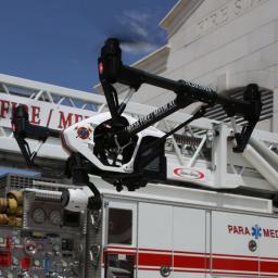 |
by Press on (#265K6)
As unmanned aerial systems (UAS) become increasingly popular and affordable, their public safety applications make them an attractive option for law and fire rescue agencies. Public safety agencies are exploring many uses, including: Search and rescue tracking Monitoring the hazardous release of chemicals Scene reconstruction and more While there are technological and operational advantages of […]
|
 |
by Press on (#265GT)
XDynamics today introduces Evolve, the world’s first consumer drone completed with a dual-screen remote controller, a patent awarded design, empowering users of all kinds with industry-grade features and functionality at their fingertips. Aerial photography and filming experience with XDynamics Evolve begins at your fingertips. Evolve redefines the consumer drones by equipping users with a revolutionary […]
|
 |
by Press on (#265GW)
Drone mapping is growing at a rapid rate in almost every country in the world. Unfortunately, incidents with drones are also growing at the same time. Just like any other aircraft, drones not only need to be flown in a safe manner but flight operations need to fully integrated within a countries civil and/or military […]
|
 |
by Press on (#265FR)
SALINA — With unmanned aircraft, or drones, a popular gift item this holiday season and beyond, the unmanned aircraft systems program on Kansas State University’s Polytechnic Campus has five essential tips to help hobbyists fly safely. Started almost 10 years ago, the Kansas State Polytechnic UAS program has made safe operations the cornerstone of its […]
|
 |
by Press on (#262T7)
The government plans to introduce new measures to ensure the successful uptake of drones is matched by strong safeguards to protect the public. Measures out for consultation today (21 December 2016) include: mandatory registration of new drones tougher penalties for illegal flying near no-fly zones and new signs for no-fly zones at sensitive sites such […]
|
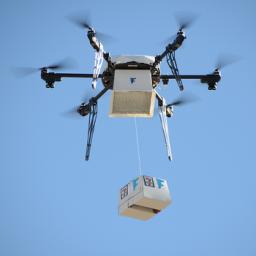 |
by Press on (#262RG)
Ed: Good old Flirtey, always ready to swoop in once Amazon opens the door again! Flirtey, the world’s leading drone delivery service, announced today they completed 77 autonomous drone deliveries to customer homes in the United States. Flirtey is the first drone delivery service to complete regular commercial deliveries to customer homes in the United States. […]
|
 |
by Press on (#262Q6)
A new report, based on research from Purdue University’s School of Aeronautics and Astronautics, analyzes the potential impact of space-based automatic dependent surveillance-broadcast (ADS-B) technology on global aviation carbon emissions in remote and oceanic airspace. Authored by Dr. Karen Marais, the report titled Environmental Benefits of Space-based ADS-B, indicates that the implementation of this technology […]
|
 |
by Press on (#261Z0)
During the past year, the number of adverse events between drones and commercial aircraft has exploded. Secure integration of drones in aviation is one of the key topics among the international aviation organisations. Therefore Arctic innovative Solutions developed the + Drone app as one important tool we hope will lead to a safer airspace. The […]
|
 |
by Press on (#261WN)
QinetiQ announces this morning that it has acquired Meggitt Defence Systems Limited and Meggitt Holdings Canada Inc. (together “Meggitt Target Systemsâ€) from Meggitt for £57.5 million on a cash-free, debt-free basis. Meggitt Target Systems is a leading international provider of unmanned aerial, naval and land-based target systems and services for test and evaluation (“T&Eâ€) and […]
|
 |
by Press on (#261WQ)
RT LTA Systems Ltd., a world-class designer, developer, and manufacturer of the Skystar™ family of aerostats for use in intelligence, surveillance, reconnaissance, and communications applications, introduces a new member of the Skystar family: the Skystar 110 . The Skystar 110 is based on the platform of the Skystar 100 micro balloon system, and includes the […]
|