A new satellite will use Google’s AI to map methane leaks from space
A methane-measuring satellite will launch in March that aims to use Google's AI to quantify, map, and reduce leaks. The mission is part of a collaboration with the nonprofit Environmental Defense Fund, and the result, they say, will be the most detailed portrait yet of methane emissions. It should help to identify where the worst spots are and who is responsible.
With methane responsible for roughly a third of the warming caused by greenhouse gases, regulators in the United States and elsewhere are pushing for stronger rules to curb the leaks that spring from oil and gas plants.
MethaneSAT will measure the plumes of methane that billow invisibly from oil and gas operations around the globe, and Google and EDF will then map those leaks for use by researchers, regulators, and the public.
We're effectively putting on a really high-quality set of glasses, allowing us to look at the Earth and these emissions with a sharpness that we've never had before," says Steve Hamburg, chief scientist and MethaneSAT project lead at EDF.
Methane experts say, however, that the path from finding a leak to getting a company to plug it will be arduous, and one that the collaboration cannot solve on its own.
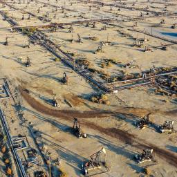
Once in orbit, MethaneSAT's software and spectrometers, which measure different wavelengths of light to detect methane, will pinpoint concentrated locations for methane plumes as well as the broader areas where the gases diffuse and spread. It will also use Google's image detection algorithms to create the first comprehensive, global map of the oil and gas industry's infrastructure, like pump jacks and storage tanks, where leaks most commonly occur.
Once those maps are lined up, we expect people will be able to have a far better understanding of the types of machinery that contribute most to methane leaks," says Yael Maguire, who leads geosustainability efforts at Google.
This tool could solve a significant problem for methane researchers, according to Rob Jackson, professor of Earth system science at Stanford. There are millions of oil and gas operations around the world, but information about where many of these facilities are located is tightly guarded and, where available, expensive to access. Some countries also block researchers from studying their infrastructure or using low-flying planes to measure emissions. With satellites, that may change.
I think AI is the future of this field, where we should be creating databases of all these infrastructure types," says Jackson. That's because measuring plumes from space sidesteps much of the oil and gas industry's opaqueness on Earth. One door that satellites are unlocking is the ability to peer everywhere. There will be nowhere to hide, eventually."
The MethaneSAT collaboration comes at a time when governments around the world are taking stronger stances on reducing methane leaks. Fueled by the momentum of COP28 in December, the Biden administration announced a new set of rules in December that will require more monitoring and repair of leaks. In January, the administration also proposed fining companies for excess methane, though that rule has not been finalized and is being fought by the industry. The European Union also agreed to stricter standards in November.
Once the MethaneSAT collaboration identifies where leaks are coming from, EDF will use the global Methane Alert and Response System from the United Nations, which sends data about methane leaks to governments and policymakers for them to act on. Hamburg from EDF says the first data and images from the satellite are expected in early summer.
Though Jackson is optimistic that more accurate data from Google and EDF will put pressure on companies, he cautions that going from awareness to action is not straightforward. One issue is that even if a particular oil and gas operation is identified as a bad actor, it's no small task to figure out who owns that infrastructure, and what tools are available to get them to act. On top of that, some regions and governments are likely to be less responsive to the data than others.
I'm not confident that simply having this information will mean that companies and countries will switch off methane leaks like a light switch," he says.