Georgetown to downtown bike route fully designed, construction could start in summer
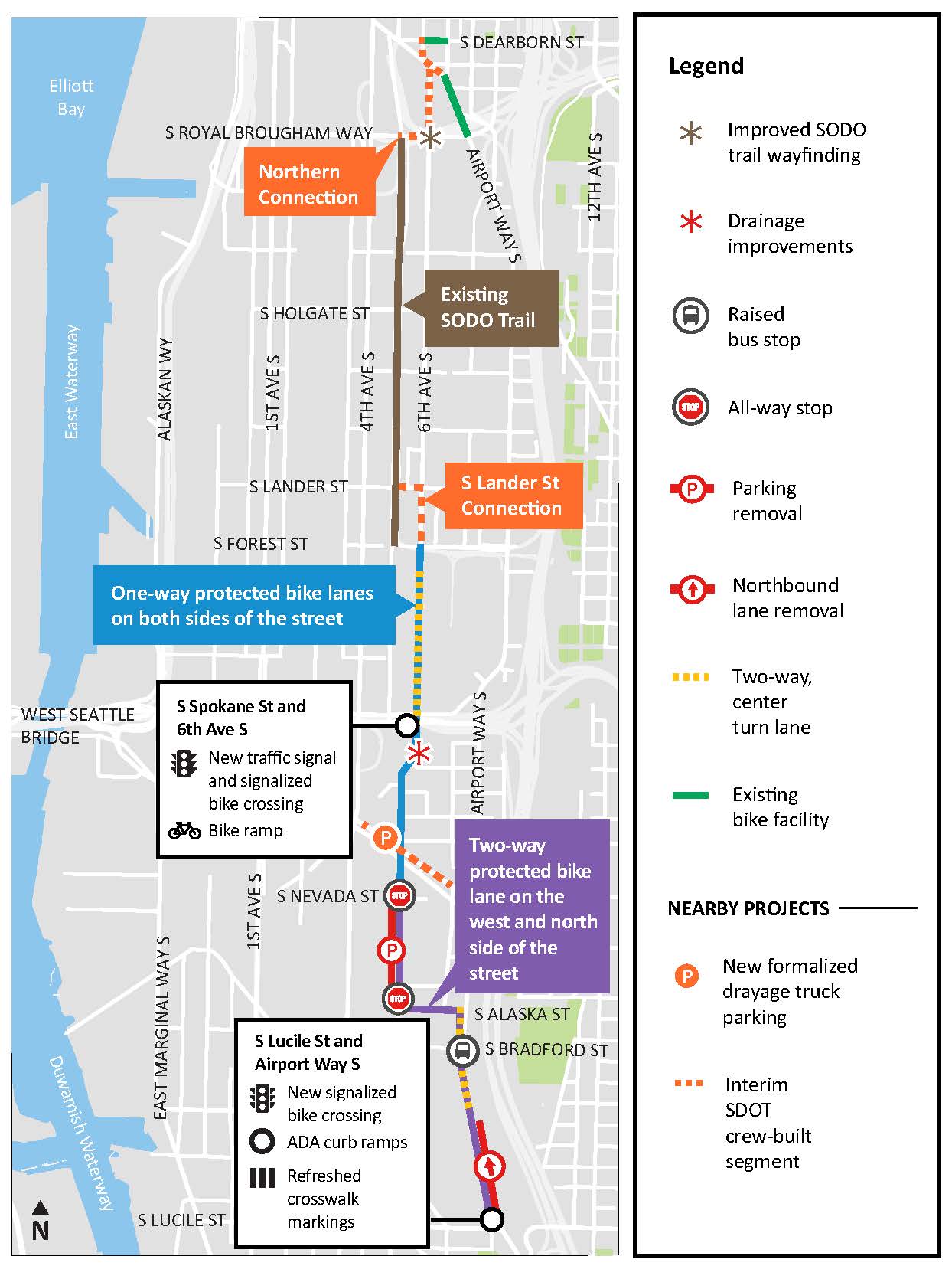 Image from the project page.
A project to finally connect across one of the worst bike network gaps in Seattle should begin construction in the summer. The Georgetown to Downtown Safety Project will build missing bike lane sections to the north and south of the SoDo Trail, connecting the International District to Georgetown. The plans are final, and the city will try to find a contractor in the spring that can start work in the summer. Work is expected to wrap up in 2025, though a more specific construction schedule won't be available until the contractor is selected and is ready to begin.
The Georgetown to downtown project is just one of three South Seattle safety project designs that SDOT recently completed, along with bike lanes on Beacon Hill and a Georgetown to South Park route. 2025 will be a big year for opening new bike connections.
The project is broken up into two main sections: North of the SoDo Trail and south of the SoDo Trail. The SoDo Trail runs adjacent to the light rail tracks between S Royal Brougham Way (Stadium Station) and S Forest Street, and it is a lovely ride lined with large murals painted on the sides of warehouses and other industrial facilities. But connections at both ends are sorely lacking, dropping people into wide industrial roads with little to no guidance or protection.
Completing the north connections is surprisingly simple, though it is really more of a mid-term solution because the area seems poised for a major redevelopment of some kind in the not-too-distant future. The connection hinges on the city and King County modifying their permit arrangement along 6th Ave S to either open the street entirely or allow a biking and walking path. A shelter opened along the street first as a Covid response facility and then as a place for people experiencing homelessness in 2020, and the street has been fully closed ever since. This complete closure, created in response to duel emergencies, was a bit short-sighted because 6th Ave S was an important biking and walking route that allowed people to skip a section of busy and fast Airport Way S. The plan essentially routes people to the north sidewalk on Royal Brougham Way for a block, then to a new path on 6th Ave S. SDOT crews will then install short sections of bike lanes on Seattle Blvd S to connect to 6th Ave S in the International District.
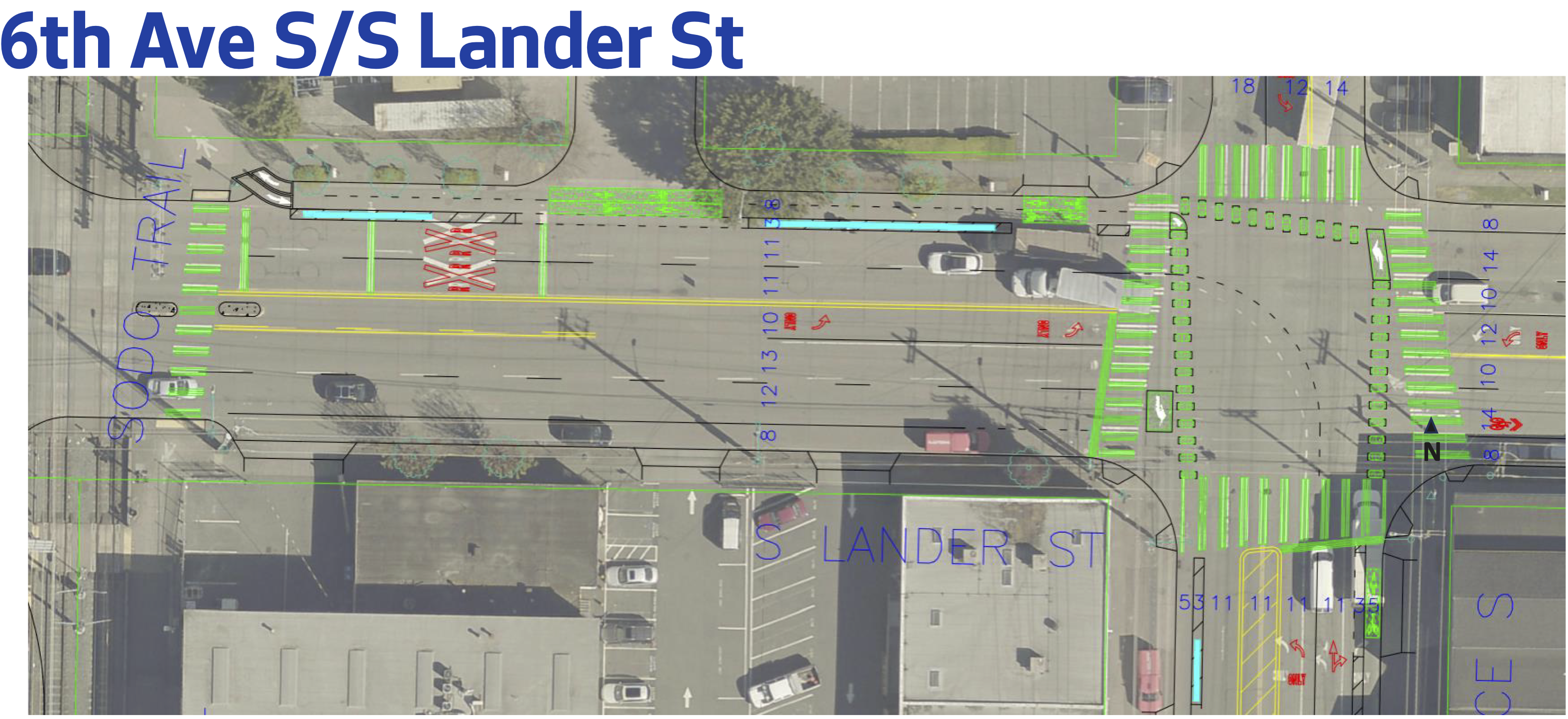 Images from the 90% design, though there have been few changes since.
The south section is much more complex. Starting from the SoDo Trail, riders will be directed to leave the trail a block early to access a two-way bike lane on the north side of S Lander Street. This bike lane will serve trail users as well as anyone heading across the Lander overpass, which routes people biking onto its wide north sidewalk. Riders will then need to transition to one-way bike lanes on 6th Ave S. This short section is being designed and delivered by SDOT rather than the contractor because they are still working out some details but didn't want to hold up the rest of the project. The plan is to build this connection to open along with the rest of the project.
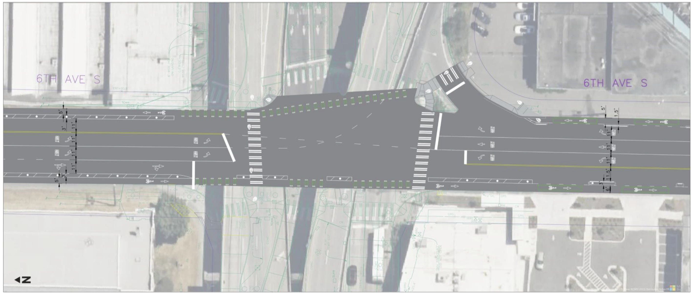
The bike lanes will continue on 6th Ave S all the way to S Alaska Street. The intersection with S Spokane Street is the most difficult spot. The northbound solution isn't great, routing people onto the sidewalk to cross a freeway ramp, but it does include a new traffic signal to separate right-turning vehicles from people walking and biking in that crosswalk. The freeway ramp spaghetti in this location is really bad, and it is difficult to work around without a major-budget redesign of how it all works. Maybe they could have done better with the bike lane here, but there's a lot of active pavement to cross. Hopefully they can use traffic signals to keep the bike lane and crosswalks as safe as possible, but this area is one to watch closely once it opens.
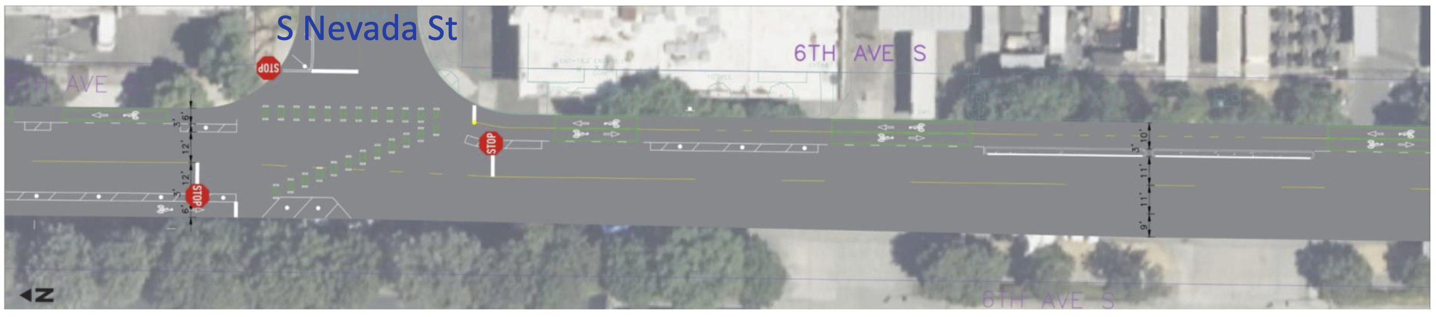
The bike lanes stay as one-way lanes until reaching S Nevada Street, where people will cross into a two-way bike lane on the east side of the street. This is a little funky, but it allows the bike route to avoid the very busy all-hours UPS distribution facility driveways, which seems like a worthwhile trade-off. The two-way lane will then turn and transition to the south side of S Alaska Street to connect to a two-way bike lane on Airport Way S, which has a rare bridge over the train yard. This will be the only north-south bridge over the train yard that has dedicated biking space.
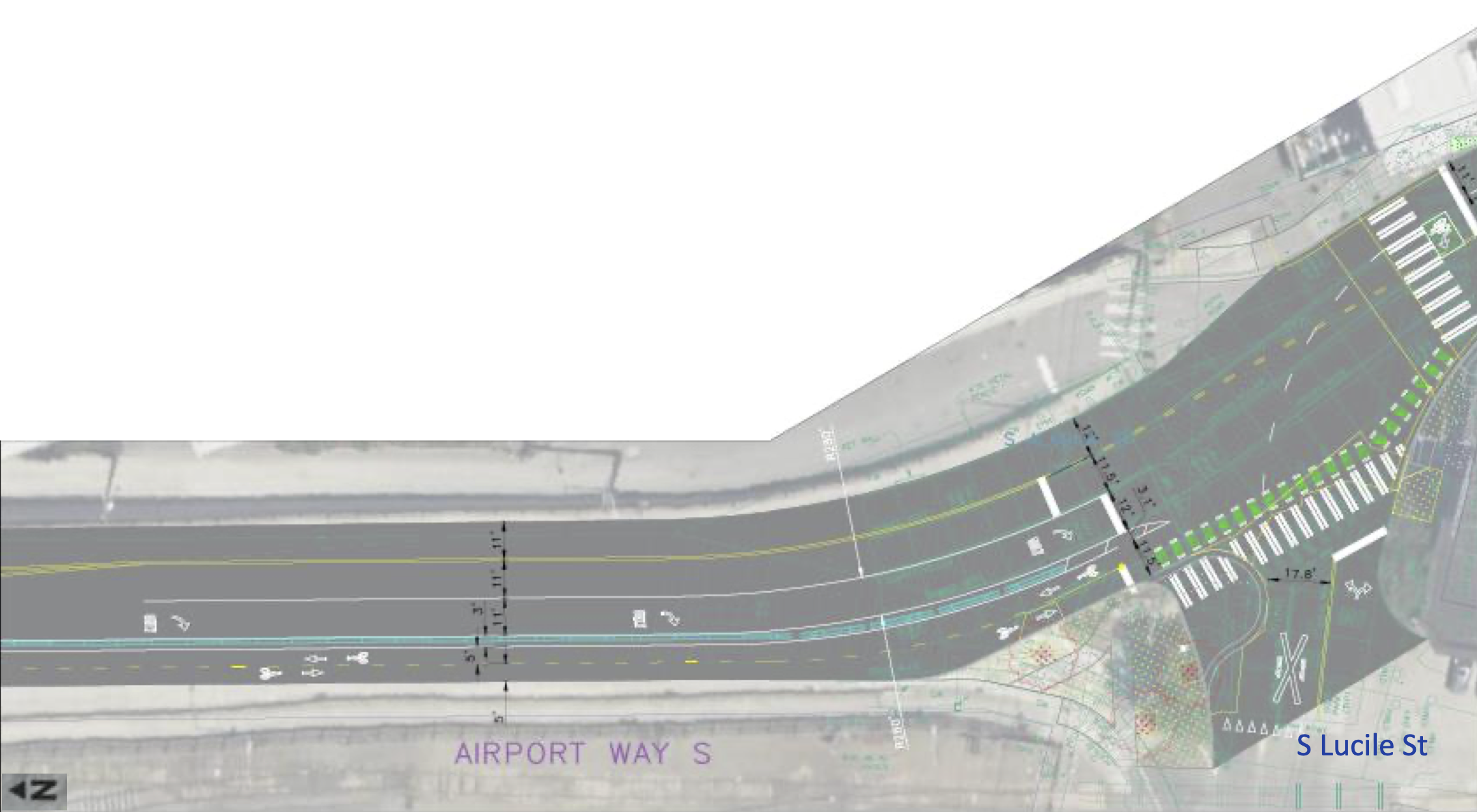
The bike lane over the bridge connects to S Lucile Street, which is getting a major new curb bulb that should dramatically improve the safety and comfort of the crosswalk there. The slip lane for right turns from the bridge onto Lucile will be closed, encouraging slower and safer turns at the intersection instead. Unfortunately, this is where the project ends. People will be let out into Georgetown, but connections within the neighborhood and to the Lucile Street Bridge one block further south will have to wait for a future project that is not yet designed or funded. Perhaps a Georgetown walking and biking circulation network of some kind could be prioritized in the early part of the city's next transportation funding measure.