Mapped: Seattle’s 2014 Bicycle Master Plan vs the proposed 2024 Transportation Plan
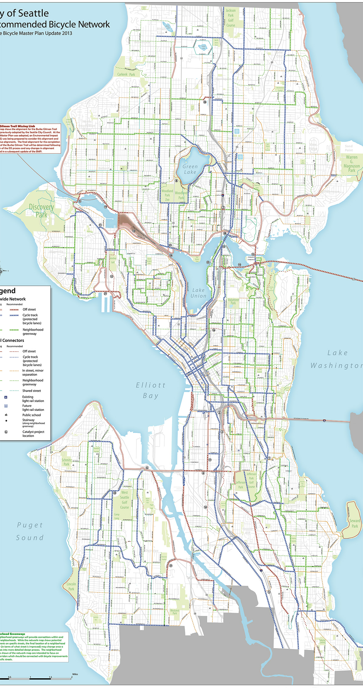
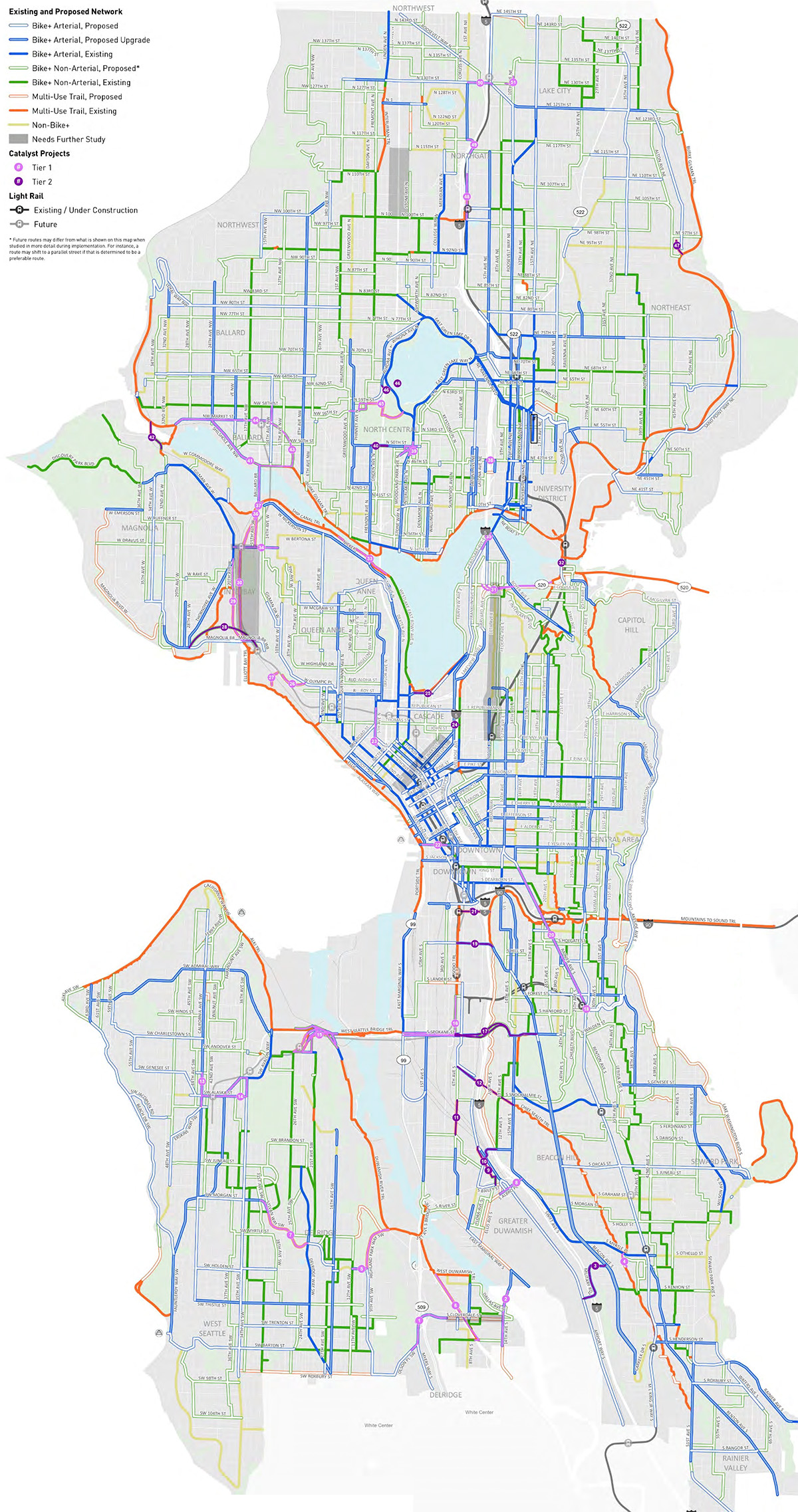 The 2014 Bicycle Master Plan Recommended Bicycle Facility map (large jpg) is on the left, and the proposed 2024 Seattle Transportation Plan Proposed Bicycle Network map (large jpg) is on the right. Images resized and composited by Seattle Bike Blog.
Once amended and approved by the City Council, the Seattle Transportation Plan (STP") will supersede the 2014 Bicycle Master Plan (BMP"). So how does it compare to its predecessor?
As we noted in our previous story, the 2014 bike plan was a very strong document, especially for its time. And its fingerprints are all over the bicycle section of the mayor's proposed STP. Mayor Bruce Harrell submitted the plan to the City Council last week, and the new Transportation Committee had its first briefing about it this week.
To help you see for yourself how the planned bicycle networks compare, I lined the maps from the two plans on top of each other to create the handy tool above. Move the slider left and right to see the changes. And let us know what you find in the comments below.
The most immediate high-level observation here is that a lot of the map changes are positive, though there are definitely some needed improvements and clarifications. Many streets that were slated for paint-only bike lanes (or uphill-only climbing lanes") in the 2014 plan have been upgraded to protected bike lanes in the proposed STP. This change reflects how SDOT has mostly been operating anyway since many of the streets slated for painted bike lanes in the old plan were actually too busy for that to be an appropriate treatment (15th Ave S on North Beacon Hill is a good example).
Some streets marked with a yellow line, however, now fall under a new category: Non-Bike+. Bike+" is a new term in the STP that encompasses any bike facility designed to be safe and comfortable for people of all ages and abilities. So Non-Bike+" streets are places where the plan acknowledges the need for a connection, but it is proposing a stub-standard facility such as paint-only bike lanes, a bike lane in only one direction or sharrows. The STP specifically states that it does not preclude these streets from getting Bike+ facilities if it is later deemed possible, but the plan estimates that the right-of-way is so constrained that an AAA bike facility is not feasible." We will discuss specific examples when we go neighborhood-by-neighborhood in future posts, but the most glaring and obvious one is Seward Park Ave S between Seward Park and Rainier Beach.
Both maps include numbered projects, which denote catalyst" projects. These are projects of unknown cost and feasibility such as new freeway overpasses or major street remakes. They may also be projects that require coordination with other agencies or partners. The city does not expect to complete these all in 20 years as part of SDOT's regular work, but they are listed in case the opportunity arises or as inspiration for an ambitious project idea that is not yet in progress. Of the 27 catalyst projects in the 2014 plan, only a couple have been completed or are in progress. We will discuss these projects in more detail in a future post.
And finally, while we can learn a lot by comparing the maps, it's important to also compare the language in the plans around how to prioritize projects and how to handle conflicting street use interests. Stay tuned for more analysis or check the blog's 2024 Seattle Transportation Plan tag to see all the posts published to date.