Kongsberg Geospatial and Survae Partner to Provide Integrated Video Management Capability within IRIS GCS
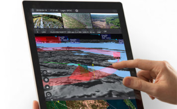 The IRIS ground control station will provide a seamless workflow allowing drone operators to manage, view, store and retrieve multiple video streams from multiple simultaneous drones. Ottawa, CA: Kongsberg Geospatial, an Ottawa-based geospatial visualisation software company, and SURVAE, a video and data mapping technology company based in Wilmington, NC, announced today that they have integrated ["]