Flattest US states

I read somewhere that, contrary to popular belief, Kansas is not the flattest state in the US. Instead, Florida is the flattest, and Kansas was several notches further down the list.
(Update: Nevertheless, Kansas is literally flatter than a pancake. Thanks to Andreas Krause for the link.)
How would you measure the flatness of a geographic region? The simplest approach would be to look at the range of elevation from the highest point to the lowest point, so that's what I did. Here are elevations and differences for each state, measured in feet.
|----------------+-------+------+-------|| State | High | Low | Diff ||----------------+-------+------+-------|| Florida | 345 | 0 | 345 || Delaware | 450 | 0 | 450 || Louisiana | 535 | -7 | 542 || Mississippi | 807 | 0 | 807 || Rhode Island | 814 | 0 | 814 || Indiana | 1257 | 322 | 935 || Illinois | 1237 | 279 | 958 || Ohio | 1549 | 456 | 1093 || Iowa | 1670 | 479 | 1191 || Wisconsin | 1952 | 581 | 1371 || Michigan | 1982 | 571 | 1411 || Missouri | 1772 | 230 | 1542 || Minnesota | 2303 | 600 | 1703 || New Jersey | 1804 | 0 | 1804 || Connecticut | 2382 | 0 | 2382 || Alabama | 2405 | 0 | 2405 || Arkansas | 2756 | 56 | 2700 || North Dakota | 3507 | 751 | 2756 || Pennsylvania | 3215 | 0 | 3215 || Kansas | 4042 | 679 | 3363 || Maryland | 3363 | 0 | 3363 || Massachusetts | 3491 | 0 | 3491 || South Carolina | 3563 | 0 | 3563 || Kentucky | 4144 | 256 | 3888 || Vermont | 4396 | 95 | 4301 || Nebraska | 5427 | 840 | 4587 || West Virginia | 4865 | 240 | 4625 || Oklahoma | 4977 | 289 | 4688 || Georgia | 4787 | 0 | 4787 || Maine | 5269 | 0 | 5269 || New York | 5348 | 0 | 5348 || Virginia | 5732 | 0 | 5732 || South Dakota | 7247 | 968 | 6279 || New Hampshire | 6293 | 0 | 6293 || Tennessee | 6647 | 177 | 6470 || North Carolina | 6690 | 0 | 6690 || Texas | 8753 | 0 | 8753 || New Mexico | 13169 | 2844 | 10325 || Wyoming | 13812 | 3100 | 10712 || Montana | 12808 | 1801 | 11007 || Colorado | 14439 | 3314 | 11125 || Oregon | 11247 | 0 | 11247 || Utah | 13527 | 2001 | 11526 || Idaho | 12667 | 712 | 11955 || Arizona | 12631 | 69 | 12562 || Nevada | 13146 | 479 | 12667 || Hawaii | 13806 | 0 | 13806 || Washington | 14419 | 0 | 14419 || California | 14505 | -282 | 14787 || Alaska | 20335 | 0 | 20335 ||----------------+-------+------+-------|
By the measure used in the table above, Florida is about 10 times flatter than Kansas.
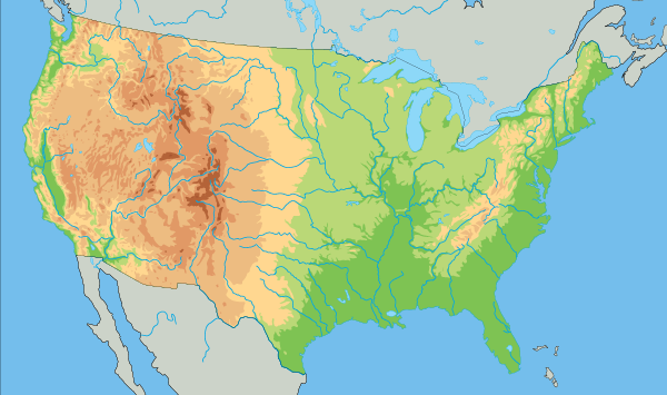
The centroid of the continental US is in Kansas, and if you look at the center of the map above, you'll see that there's an elevation change across Kansas.
If I remember correctly, the source I saw said that Kansas was something like 9th, though in the table above it's 20th. Maybe that source measured flatness differently. If you had a grid of measurements throughout each state, you could compute something like a Sobolev norm that accounts for gradients.