A traveling salesman tour of Canada
by John from John D. Cook on (#64C4Q)
Here is a Traveling Salesman tour of Canada's provinces and territories created by Mathematica. This is the shortest path connecting the geographic centers of the regions.
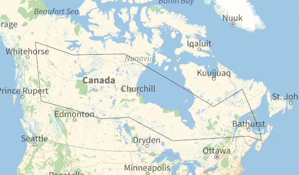
Here is a much larger (4.5 MB) PDF file of the same map with higher resolution.
Starting in the northwest, the tour is
- Yukon
- Northwest Territories
- Nunavut
- Quebec
- Newfoundland and Labrador
- Prince Edward Island
- Nova Scotia
- New Brunswick
- Ontario
- Manitoba
- Saskatchewan
- Alberta
- British Columbia
The tour is 11,070 km.
For more tours like this, see my earlier posts on tours of
Update: Here is an adjacency network for Canadian provinces and territories.

This is an SVG image so you can scale it to make it easier to read if you'd like.
More adjacency graph posts:
The post A traveling salesman tour of Canada first appeared on John D. Cook.