Latest Alaskan Way design includes continuous waterfront bike lane with plan for cruise detours
 Images from SDOT.
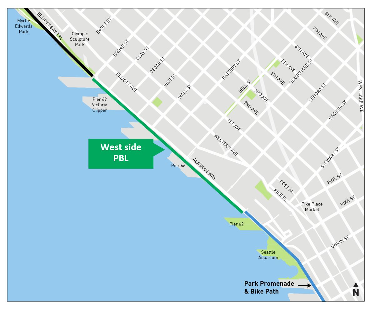
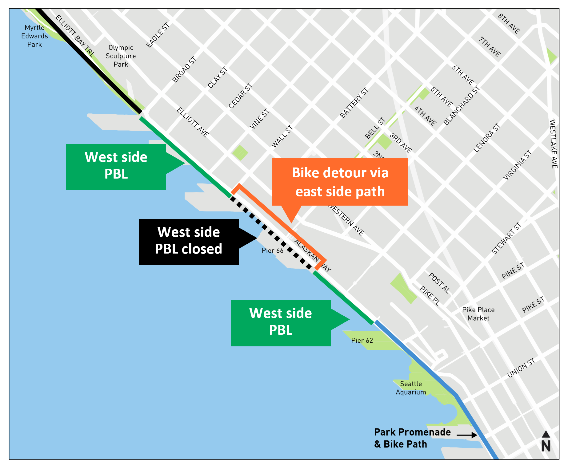
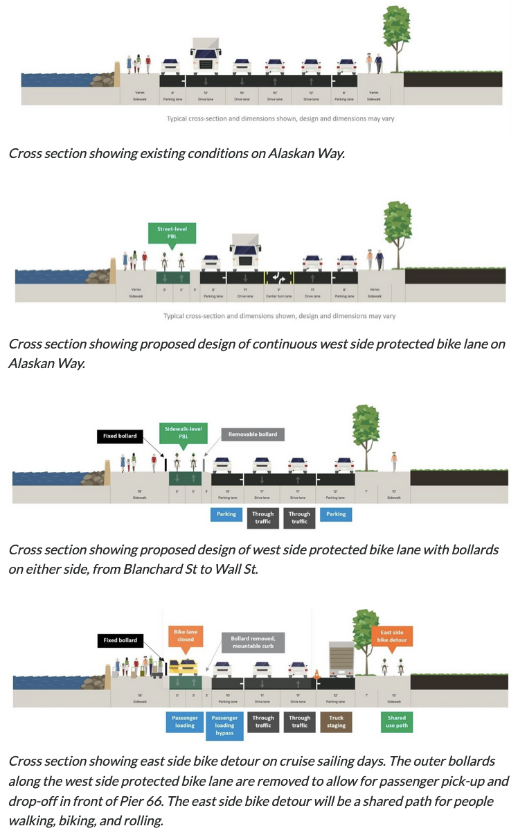
The city plans to build a continuous bike lane on the waterfront side of Alaskan Way under the latest design, SDOT announced Monday. Rather than permanently detour the bike route across Alaskan Way twice within a couple blocks, the new design includes a detour plan for use only during busy cruise ship loading times in the area around Pier 66. This compromise solution came together after significant discussions between the Port of Seattle, Cascade Bicycle Club and the city. A recent push by Seattle Neighborhood Greenways also got more members of the public involved, sending letters of bike lane support directly to Port Commissioners.
Cascade celebrated the news, writing in an email to supporters that more than 700 of you joined us to ask planners to go back to the drawing board.' They did just that."
The new design creates a continuous, protected bike lane that will be open the majority of the year," Cascade continued. There will be a short detour only during cruise hours so that we can bike around the chaotic crowds (and their luggage). When it's complete, families, visitors, commuters, and others can ride safely and comfortably along the waterfront without zig-zagging across the street and back for most of the year." Cascade is encouraging people to use their handy online form to send a thank you note to the city's transportation officials and leaders that also encourages sturdy bollards to protect the bike lane and intuitive signage and signalling when the detour is in place.
During cruise operations, the detour would cross at Blanchard and Wall Streets, which already have traffic signals. The path would then follow a path that is partially built already, though it appears the city will need to remove more of the old George Benson Streetcar tracks to create space for the path. Below are diagrams of the two intersections from SDOT:
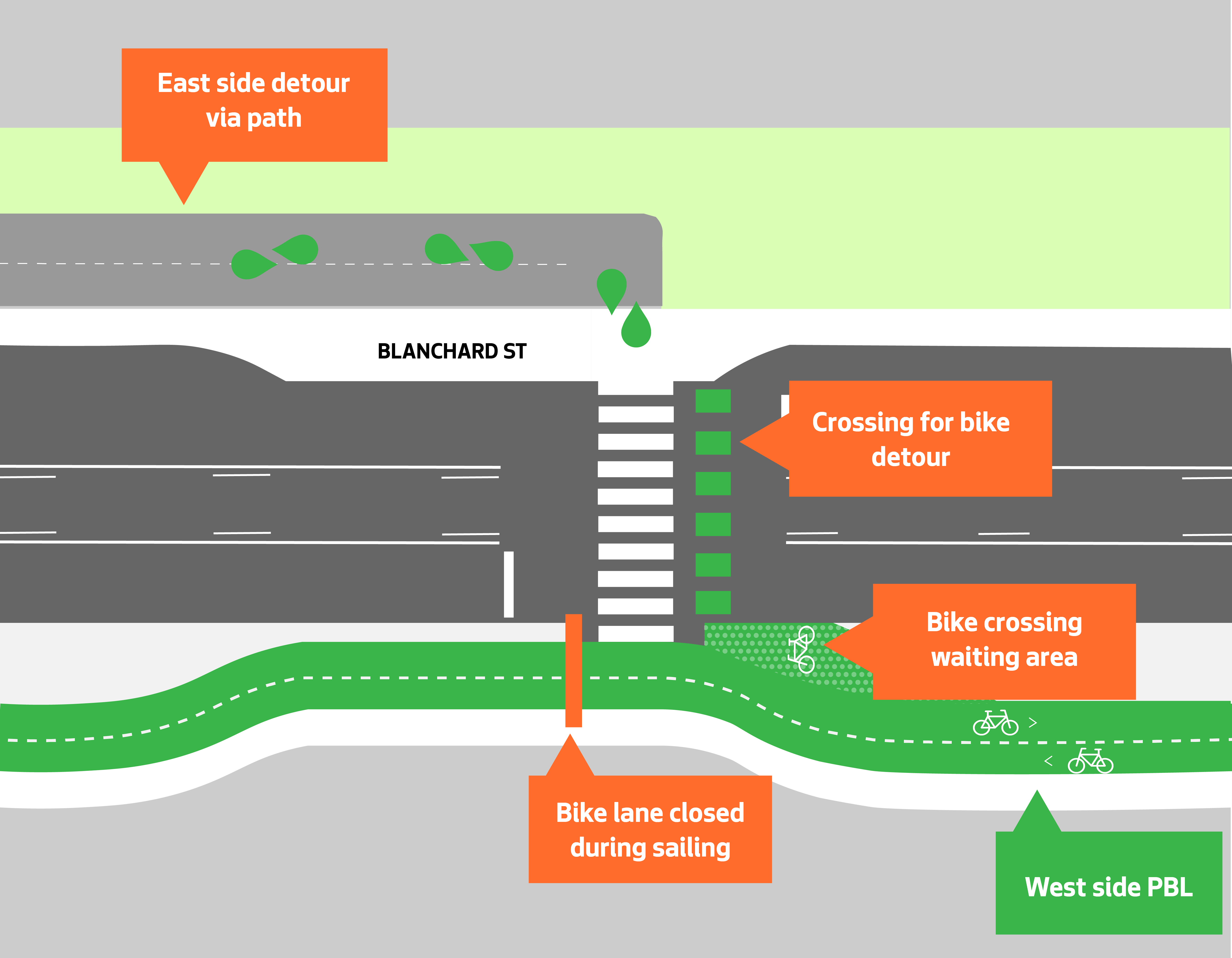
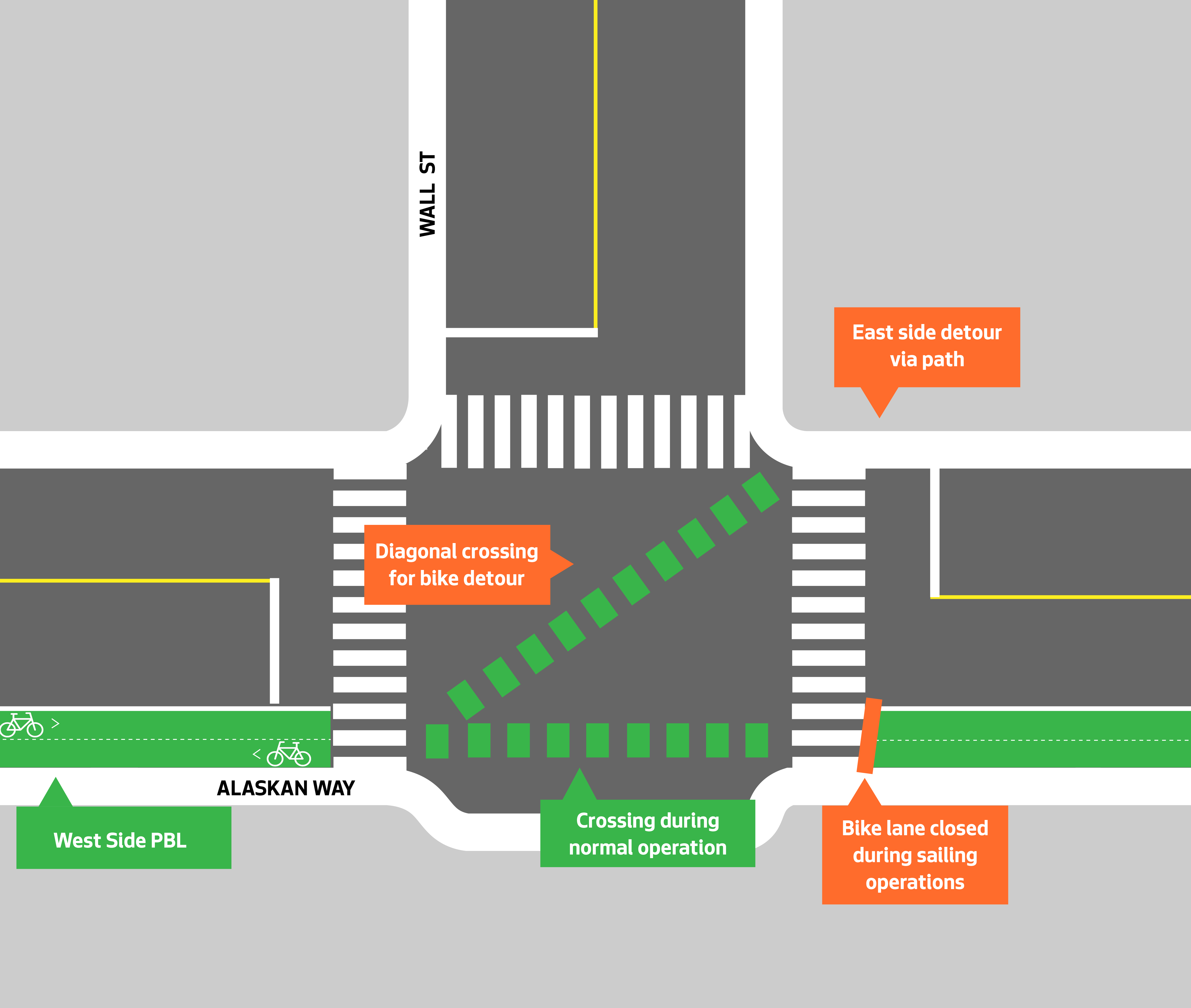
 I noticed on a recent visit that this path does not yet reach Wall Street, so significant work will be required to complete this detour path.
For both these crossings, the details will make or break the designs. If traffic cycle times are too long, for example, people may give up waiting and just bike in the street. But if the signals are responsive, people will follow the detour.
The crux of the unique design of this stretch of the waterside bike lane is a mountable curb lined with removable bollards. There are still details to work out here, such as how sturdy the bollards will be and what the procedures will be for removing them. But Seattle has had experience with a somewhat similar concept in the past. On N 34th Street in Fremont, the city built a two-way protected bike lane that is designed to be used by vendors during the Sunday Market. The city even spaced out the bollards to match the width of the average market canopy so that vendors could set up between them without needing to worry about a bollard getting in the way of customers, which is such a clever solution.
 Images and captions from SDOT.
This sensible compromise," as Cascade calls it, puts the project on pace to be complete by mid-2025 along with the rest of the waterfront bike path, creating a complete and connected bike route for the entire downtown waterfront that connects to the West Seattle bike network in the south and the Elliott Bay Trail through Interbay and beyond to the north. This trail is likely to become the most impactful new bike route Seattle has constructed in many years, perhaps decades.
What should it be named?Right now, parts of this trail is called the Alaskan Way Trail, other parts are referred to in city materials as the Waterfront Trail, and the section to the north has long been called the Elliott Bay Trail. I suspect that without an intentional renaming, people will refer to the whole thing as the Elliott Bay Trail or the Waterfront Trail. These could be fine names since people already use them, but the city could consider this opportunity for a whole new naming scheme to go with the opening. The branding and marketing of this new path is a chance to redraw people's mental maps of the waterfront. People should be able to have one name to describe the mishmash of routes that are all finally coming together to become something new.
Here's one idea: Because the whole waterfront trail route will connect to the existing Duwamish Trail and because one of the older names for Elliott Bay was Duwamish Bay" and because this city is on the land of the Duwamish people, Seattle could use the name Duwamish Trail" to refer to the whole trail from South Park to Smith Cove. This would also help clear up the naming for some sections of those West Seattle-bound trails that often refer to as the Alki Trail" even though they aren't really part of that trail. Instead, the Alki Trail could start where it intersects with the Duwamish Trail.
If you have other naming ideas, I'd love to hear them.