SDOT releases early design for Leary/Market bikeway, seeks feedback
The day before Thanksgiving, SDOT released a first look at their design concept for a Ballard Missing Link bike route alternative following 17th Ave NW, Leary Way and Market Street. The plan includes a 10-foot-wide multi-use trail" on one side of the street as well as significant traffic calming and safety upgrades to Leary Way especially. However, the Market Street design points to why that short section will be by far the most difficult part, and the initial design calls for a significant reduction in the sidewalk space and removal of trees.
The team is working on a rushed schedule with hopes of reaching 30% design by the end of 2023. They will be out at the corner of NW Market Street and 24th Ave NW from 3-5 p.m. Tuesday (Nov. 28) collecting feedback. You can also complete their very short online survey.
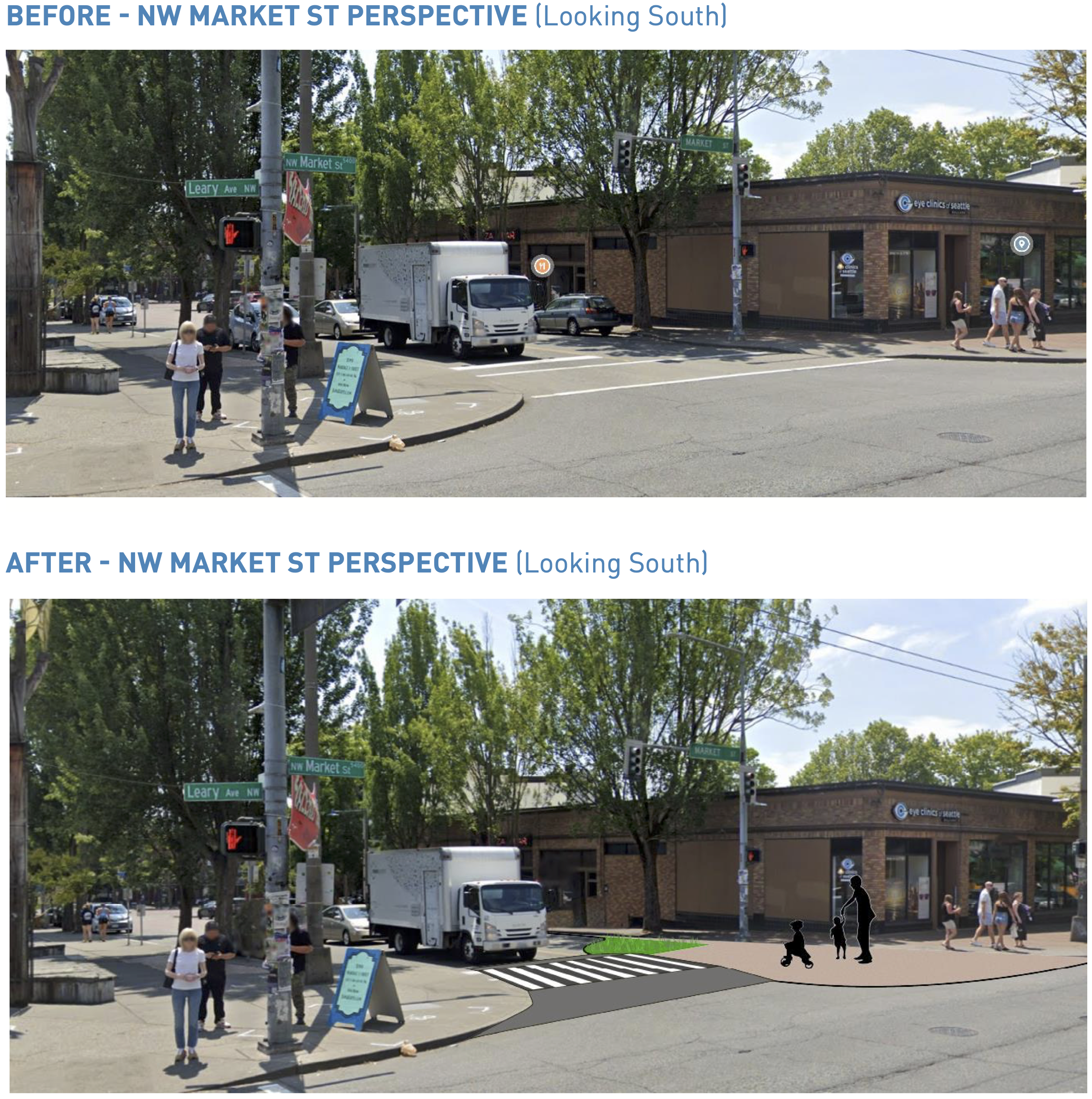
Market StreetLet's start with the trickiest part: NW Market Street between Leary Way and 24th Ave NW, where the existing not-a-trail section begins. This is the heart of Ballard's business district and has a ton of people on foot. It also carries Metro's 40 and 44 bus routes. The 44 in particular is one of Metro's busiest routes. Car volumes are not actually too bad, with SDOT measurements coming in at 10,300 vehicles per day in 2019. For reference, the street carried about 28,600 vehicles per day just a few blocks east near 15th Ave NW, but most people turn before hitting the busy business district. But there are a lot of turning movements, and traffic engineers will need to be careful that cars don't back up in a way that impedes the bus routes.
 You may need to click the images and zoom in to see the dimensions.
The crux of the design seems to hinge on redesigning the bus stop to have an 10 ft wide pedestrian loading area closer to 22nd Ave NW," and then using the existing bus shelter and tree planting space for a sidewalk-adjacent bike path. New trees would then be planted closer to the street. This could all be done without significantly reducing the space for cars and buses, allowing them to maintain some short bus-only lanes. However, it raises a lot of questions about how this will impact the walking experience as well as how to maintain separation between people biking, walking and waiting for the bus.
All these trade-offs and compromises are happening within the already-limited walking realm. But why are engineers so focused on preserving a four-lane design for a street running through a major business district with such high levels of foot traffic? Instead of pushing compromises onto the walking, biking and transit user spaces (not to mention the trees), let's see some design ideas that utilize some of the 51 feet of roadway space. Instead of bus lanes for the bus stops, how about in-lane stops like already exist in other parts of the 44 route? They seem to work great in situations like these. Designers could also make significant safety improvements to all the Market Street crosswalks while they're at it, shortening the crossing distances and slowing vehicle turns.
My worry is that there are so many people walking on this street, especially during busy hours, that they will naturally spill into the trail space. And if it is difficult and slow to try to bike through here and navigate around people walking on the path, then people will just go back to biking on Shilshole Ave. That is already an inherent risk in this whole Leary/Market project, since Shilshole will be the fastest and most direct bike route between the two ends of the Burke-Gilman Trail. That's why Shilshole was overwhelmingly supported as the preferred route for the Missing Link during the extensive public outreach of the past decade. The only way it will draw people away from Shilshole is if it is so comfortable and safe that it is worth the extra time. This isn't me being picky here, I'm just stating how things will work whether SDOT or I want them to or not. People will always bike the path of least resistance.
Leary WayNow, for the good stuff. The design for Leary Way is extremely exciting. That street is wide, fast and on an angle against the grid, creating all these terrible intersections and terrible crosswalks. It is begging for a safe streets redesign, and the project team did not disappoint in these early designs. The street will be transformed into a much safer three-lane design for vehicles with one general purpose lane in each direction plus turn lanes, bus lanes and parking lanes as appropriate. By adding the 10-foot trail onto the existing sidewalk space on the west side of the street, the design will dramatically expand the walking realm and shorten all the crosswalks. But that's not all. The design also includes intersection redesigns on the east side of the street to square up the turns, dramatically improve crosswalks and slow turning vehicles.
 Click for details (20MB file size).
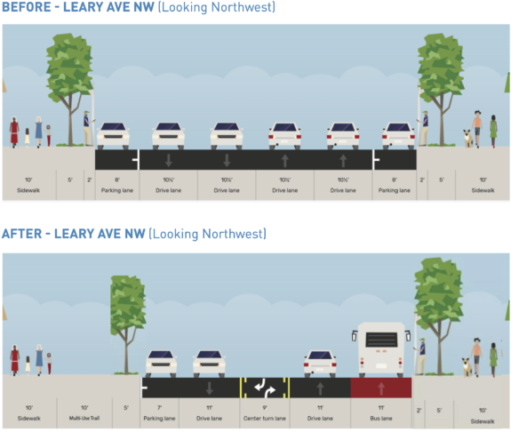
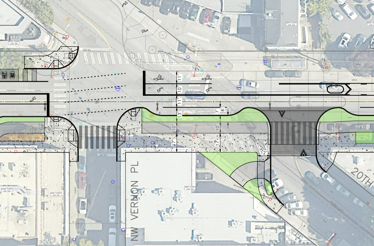
I'm sure there are some relatively small details to work on, but I am very excited by the Leary Way design. This would be such a dramatic improvement for this street. For example, look at the design for the strange and gigantic three-way intersection with 20th and Vernon Pl:
These kinds of changes might just make Leary a street people actually want to spend time on rather than a high-speed barrier separating businesses from nearby apartments. I would love to see the Leary strategy applied to the Market Street section.
Like the other segments, though, this design would result in a lot of tree removal. There do seem to be places where the trail could possibly route around the trees if parking were removed or lanes were shifted. I'm not sure. But I suspect tree loss will not be popular.
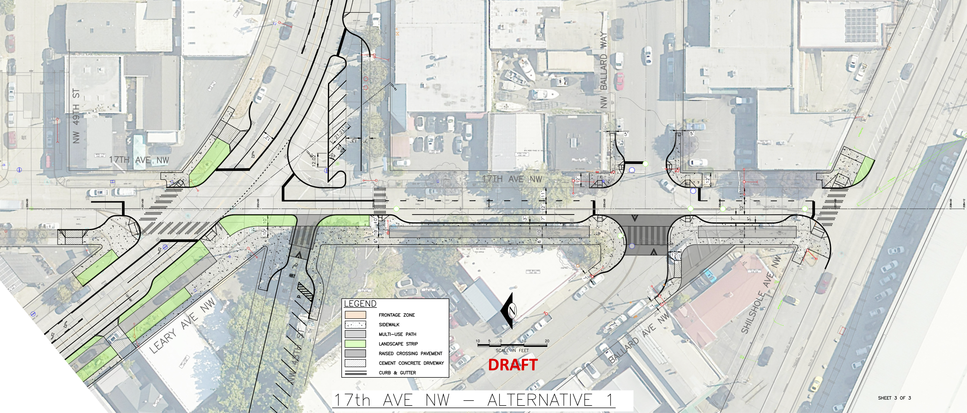
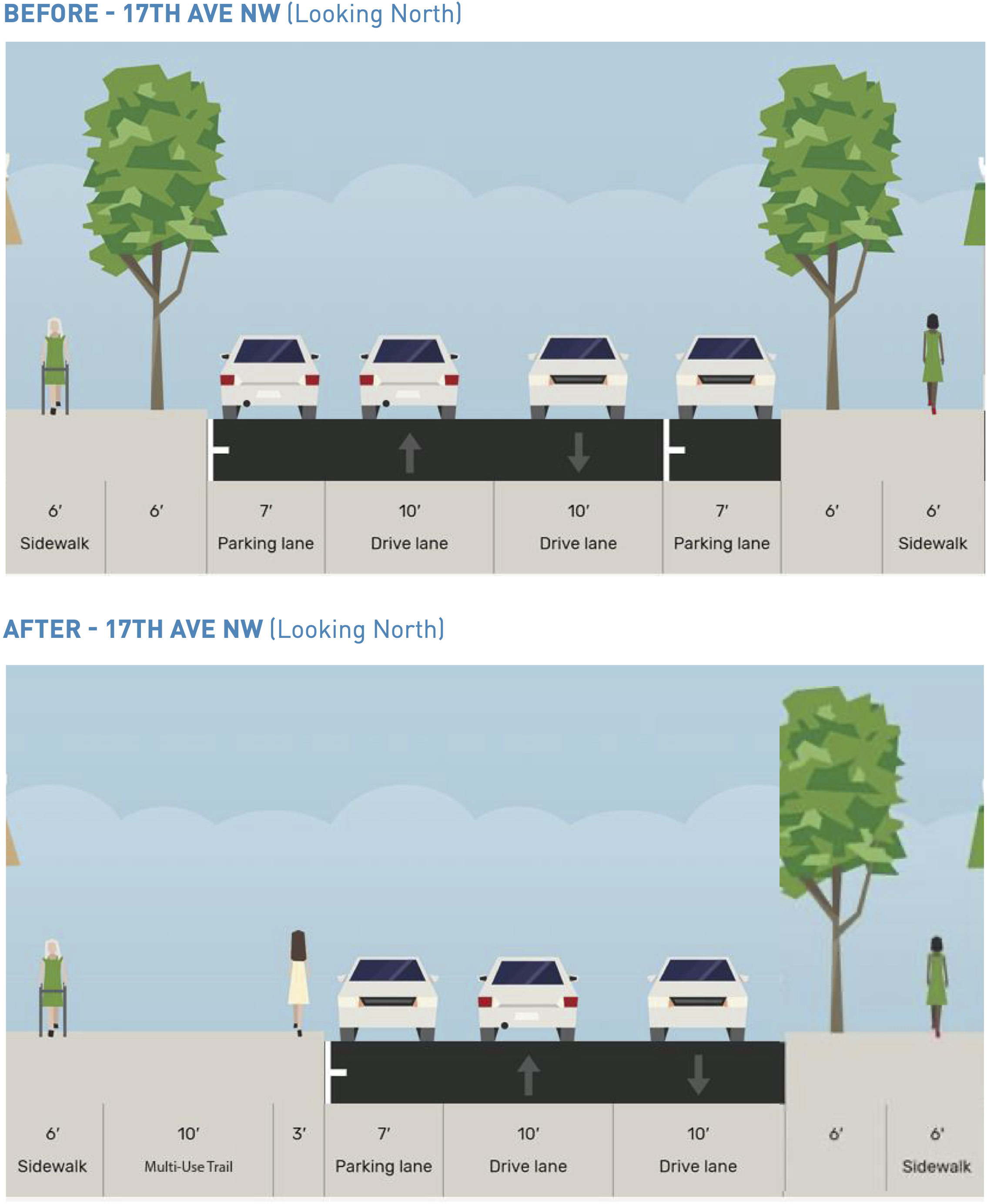
17th Ave NWThe planned route would connect to the existing bike lanes serving as a not-so-temporary bike route on NW 45th Street via a new trail on 17th Ave NW. The primary thing to note here is that there are 5 trees in the trail path. It's really not a very busy street. I wonder if they could make it a one-way street or something to avoid more tree loss and curb work than is absolutely necessary. This is a part of the neighborhood that is already somewhat lacking in tree cover, especially the parts east of 17th.
 Conclusion
You can scour the details in SDOT's design roll plot (11 MB PDF). Other interesting details include some new angled parking in places, perhaps to offset any parking loss.
In general, I am ecstatic about the Leary Way safety improvements. Market Street seems very compromised in favor of preserving space for traffic, and SDOT can do better here.
The trail is a consistent 10 feet wide, which is below the standard of 12 feet. However, since it is next to a sidewalk, this skinnier width could still work. But it would need to be designed more like protected bike lanes and less like a multi-use trail. I think the brief must have specified multi-use trail" for this project, but it's just not the correct tool for this situation. A protected bike lane is more appropriate for these commercial sections with adjacent sidewalks.
I am also concerned about the bike and walk mixing zones at essentially every street corner. People walking and biking should be properly separated. Otherwise people waiting to cross the street will be standing in the way of people trying to bike the route, which is just not a good situation for anyone involved. I'm not sure where they got this idea for mixing zones, but this won't work. The only places in Seattle where it is at least somewhat successful are place where people on bikes are waiting for a traffic signal (like 7th Ave at Westlake Ave). But the key is that people on bikes are not trying to pass through while people are waiting for the signal because people walking and biking all get the signal to go at the same time. Look at this example on Market where it crosses 22nd Ave NW:
The trail" here is just people biking on the sidewalk, which is not a good solution for such a busy business district. I don't think anyone has been asking for more sidewalk bike riding. People walking on the sidewalks won't like it, and people biking won't like it. Again, a protected bike lane is a more appropriate solution.
A great project is possible here, but SDOT cannot cut corners and compromise the biking and walking experience in order to get there. If they do so, the project will fail.