Seattle’s mixed history building neighborhood greenways
Neighborhood greenways have a hit and miss history in Seattle. Sometimes they create fantastic all ages and abilities walking and biking connections, and sometimes they are so heavily compromised that they do very little. So as Seattle prepares to create a new transportation plan and craft a new transportation funding measure, we should probably get a handle on what works, what doesn't and why.
Ryan Packer at the Urbanist posed the issue in a recent post:
Seattle's greenway network turns 12 years old this year, with the 39th Avenue NE greenway in Wedgwood one of the very first corridors that the Seattle Department of Transportation (SDOT) upgraded when it tried out the idea in mid-2012, right after N 43rd and N 44th Streets in Wallingford. At the time, Seattle was following in the footsteps of Portland, Oregon, which officially started branding its bike boulevards neighborhood greenways" in 2009, but which had been implementing projects like them going back to the 1980s.
As Seattle starts to consider the next iteration of the 2015 Move Seattle levy, which expires at the end of the year, the city has an opportunity to reassess how neighborhood greenway infrastructure has been implemented, and how big of a role the continued expansion of the network should have moving forward. With significant gaps still remaining in the on-street bike network, and many miles of bike lanes still in need of upgrades in the form of physical protection and signal infrastructure, 2024 could be a key decision point.
Read more...
Most (or perhaps all) of the worst neighborhood greenways in Seattle have one thing in common: They were created not to build new connections for people but rather as a way for SDOT to avoid building bike lanes and better crosswalks on a nearby arterial street. Many of the city's worst neighborhood greenways were started for the wrong reasons and had project-breaking limitations baked into them from day one.
A great (or terrible?) example is the stretch of neighborhood greenway on 17th Ave SW in Delridge. Picture this: You're biking along, following the helpful signs pointing the way along the neighborhood greenway when all of sudden there is a staircase in the middle of the road.
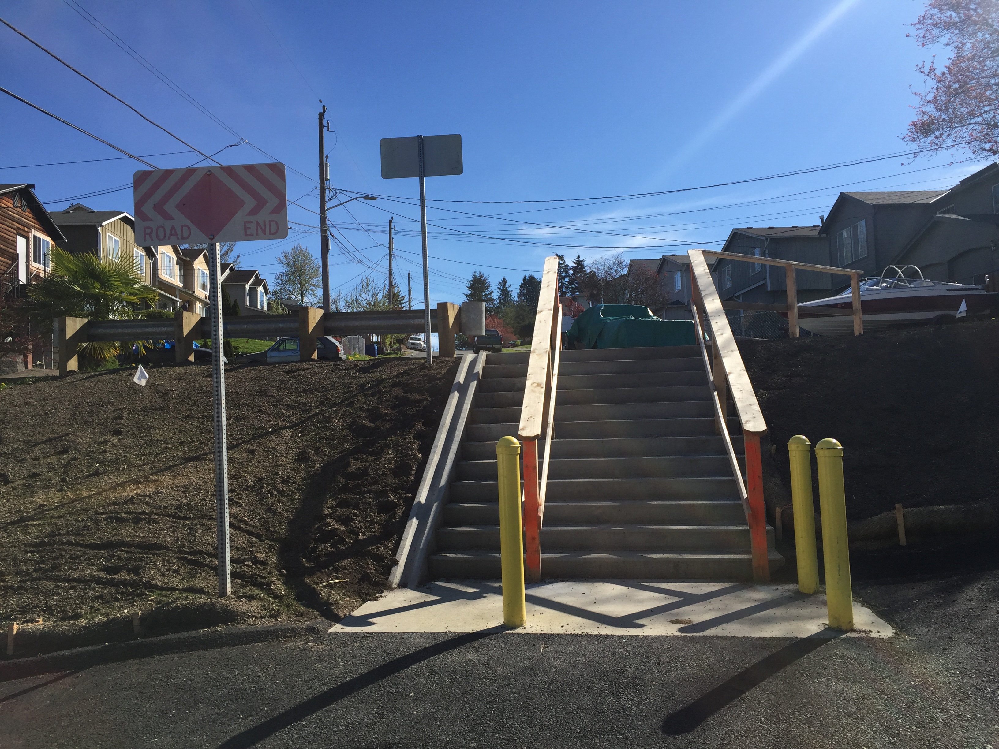 Photo from a 2016 ride shortly after the route opened. Not only is this a poor feature for a bike route, but it also neglects the all abilities" goal.
You have to get off your bike, then try to maneuver the tires into a runnel" so you can push it up 12 steps before you can continue on. Then a block later, the route turns and crosses 16th Ave SW at a traffic signal only to travel two blocks on 15th Ave SW before crossing 16th Ave SW again at another traffic signal before turning back onto 17th Ave SW. If you follow the greenway route, it genuinely feels insulting when you cross the street the second time within sight of the place where you just crossed a minute ago.
 It's not a great photo of 16th Ave SW, but that traffic signal down there is the one you just used a few minutes ago.
It feels like the city is messing with you. Why would they waste your time like this? Rather than creating a comfortable and welcoming experience, traveling this section of neighborhood greenway feels like the city is telling you to get out of the way of the people it values more: People driving (and parking) cars.
Perhaps an more well-known example, however, is the Rainier Valley Neighborhood Greenway. There are parts of the route, especially near Columbia City, where the greenway route makes some absurd climbs and turns in order to avoid using the only obvious option for traveling north and south through the business district: Rainier Ave.
But other parts of the Rainier Valley Greenway are great examples of how a neighborhood greenway can be an effective tool for creating new connections. When the route is trying to be its own thing, it's kind of great, but when it tries to replace Rainier Ave it is terrible. It's a great route for getting from Sam Smith Park and the I-90 bike tunnel to Franklin High School and John Muir Elementary School, for example. I also like the way it connects into Genesee Park. There is no single arterial street that makes these connections the way the neighborhood greenway does. I also love the way it connects into the paths through the playfield near Dunlap Elementary and South Shore K-8. It feels like you've found a secret. The route takes you almost through people's home gardens in a really lovely way. When the greenway is allowed to be itself, it's a great addition to the neighborhood. But it is not and never will be a replacement for bike lanes on MLK and/or Rainier Ave.
Another example of a great neighborhood greenway, look at the Beacon Hill Neighborhood Greenway, which connects the Mountains to Sound Trail at 18th Ave S to Beacon Hill Station, Jefferson Park and then to Georgetown via the Lucile Street bridge. There is no arterial street that makes this connection. Instead, the greenway route invented a new connection based on organizing from within the neighborhood. I still think it is one of the best neighborhood greenways in the city.
One common problem on many of the city's neighborhood greenways, including some sections of the Rainier Valley route, is SDOT's reluctance to install actual traffic diverters (also known as traffic filters" since they allow biking and walking but not driving). Diverters are the elements most likely to face pushback from neighbors who don't want to drive around the block or people who like to use the street as a cut-through, but without them the streets often feel too dangerous to meet their all ages and abilities goals. A greenway should be considered a failure or incomplete if a child cannot comfortably bike there. Ideally, the only people driving on a neighborhood greenway are people accessing a destination on that street. Once you have people driving there who are just trying to get somewhere else (possibly because Google Maps told them to do it), you lose the comfortable pace and welcoming feeling that makes these routes work. Diverters should be placed at regular intervals along these routes. And they need to be concrete and permanent, not just a sign that people can either run over or ignore.
We also need to more effectively work Seattle Parks into the neighborhood greenway plans. So far, SDOT has mostly avoided routing greenways through parks, but parks are often the highlights of a bike route. Parks also form a kind of traffic diverter, making routes that travel through them that much more pleasant. Obviously not every park or path is appropriate for a designated bike route, but we need SDOT and Parks to both want to identify and activate the opportunities we do have. As it is, we rarely see effective collaboration between the two departments around the goal of building bike routes, and that's a shame.
Neighborhood greenways can be great, but they need to be built for the right reasons and with the top priority of creating a space that is safe and comfortable for people of all ages and abilities to walk and bike. The city should figure out a way to codify these goals and standards in city policy and in the next transportation funding measure.