The 20-year bike plan for S/SE Seattle: Beacon Hill and Rainier Valley
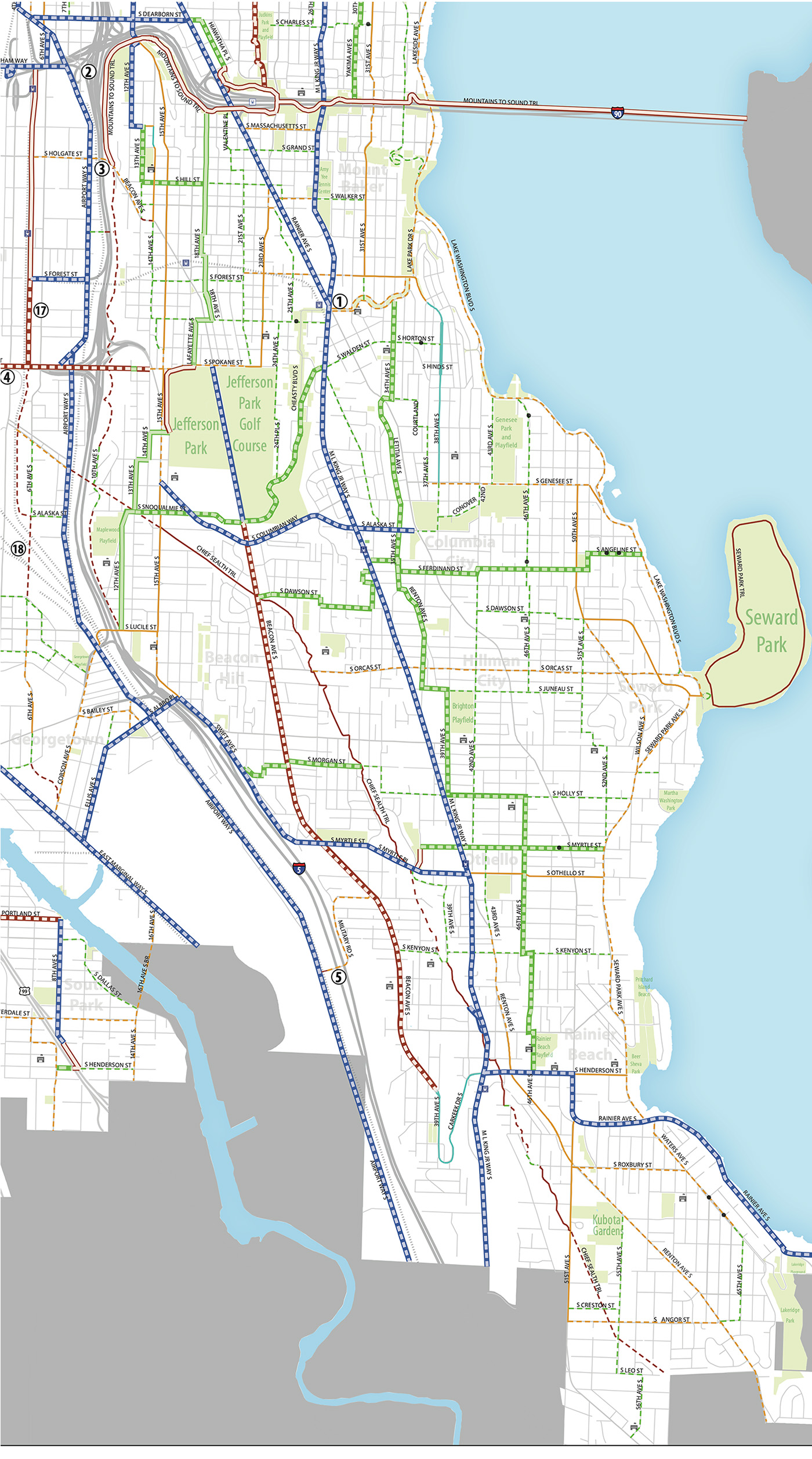
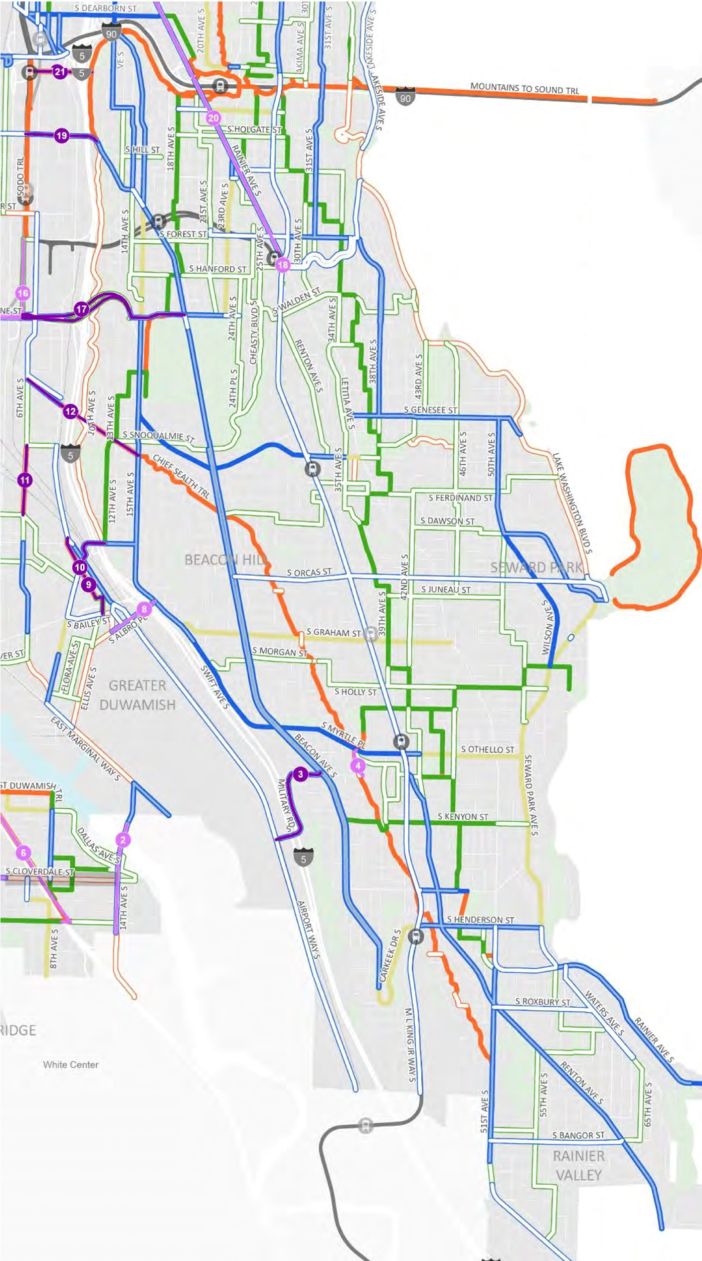 Download larger JPG images of SE Seattle from the 2014 Bike Master Plan and proposed 2024 Seattle Transportation Plan.
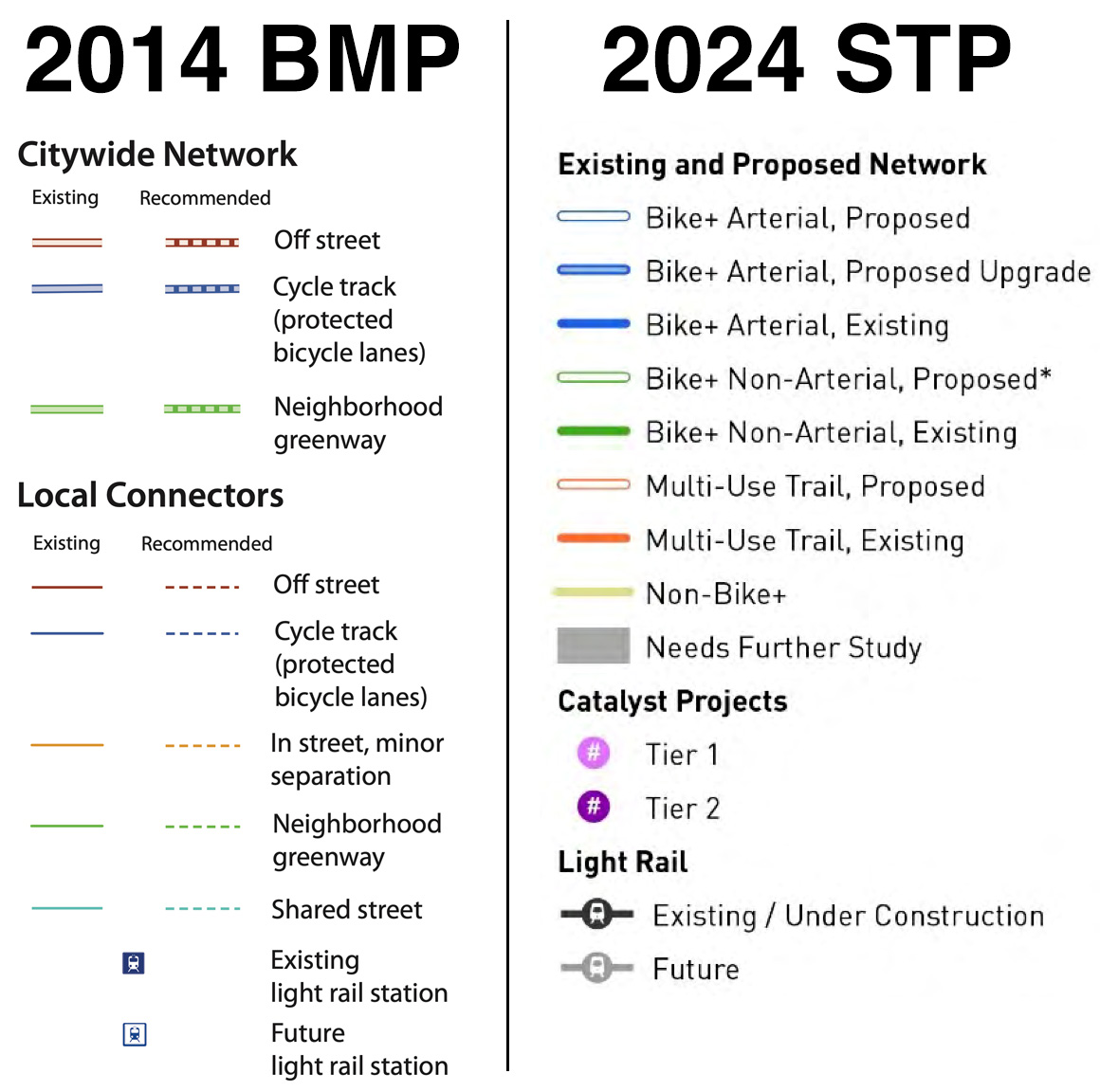
Mayor Bruce Harrell's proposed Seattle Transportation Plan (STP") is now in the hands of the City Council, who can make some final changes before adopting it as official city policy. The STP will supersede the 2014 Bicycle Master Plan, so it's important to take a close look at its vision for the next 10-20 years of bike improvements across the city. To do so, Seattle Bike Blog will post a series of six stories focusing on different areas of the city. You find other areas as well as other STP-related stories through the 2024 Seattle Transportation Plan tag. First up: Southeast Seattle, including Beacon Hill and the Rainier Valley neighborhoods.
Right away, it should be clear why we needed to break map analysis into a series of posts. There's so much to talk about here, but let's get straight into the big one: Northern Rainier Ave S is listed as a tier 1 catalyst project" with bike lanes between MLK Way S and S King Street. The description says only that it would provide an all ages and abilities bicycle connection between the Judkins Park light rail station, Chinatown International District, and Mount Baker." As a tier 1 project, it is among the highest priority catalyst projects. It is likely listed as a catalyst project rather than just another bike lane because it would be complex and require a partnership with WSDOT and perhaps also Sound Transit due to the I-90 access ramps and underpass. For many years, this project has been at the top of the priority list for the Seattle Bicycle Advisory Board because there is no comparably flat and direct option for connecting Rainier Valley and downtown. The area under and around I-90 is also in desperate and urgent need of major safety changes for biking and especially walking, preferably before Judkins Park Station opens. So my major comment here is that the Council should consider ways to bump the priority of this project as high as they can. It stands out among the rest of the tier 1 projects (it's S tier). Or better yet, earmark year-one funding for it in the next transportation funding measure and maybe even get early design work going ASAP. It would also be a great poster child for showcasing the benefits of voting YES in November. Perhaps no other project in the city would be more impactful for walking, biking and transit access than this one.
Beyond this catalyst project, the STP makes the same decision that the BMP made by calling for protected bike lanes on MLK Jr Way and for no bike improvements on Rainier Ave south of MLK. We argued against this decision back in 2013, and continue to argue against it now. All of Rainier Ave needs to be safe for everyone, including people on bikes. It is where most the neighborhood destinations are, and it cuts against the street grid in such a way that there are many places where there are no viable alternatives. Leaving Rainier out of the city's bike plan continues to be a mistake.
Much of the good stuff in the BMP is maintained or upgraded in the STP, including many routes on Beacon Hill that were part of a really cool neighborhood-created walking and biking circulation plan from 2011. Here we are 13 years later, and that neighborhood organizing is still imprinted in new city policy documents.
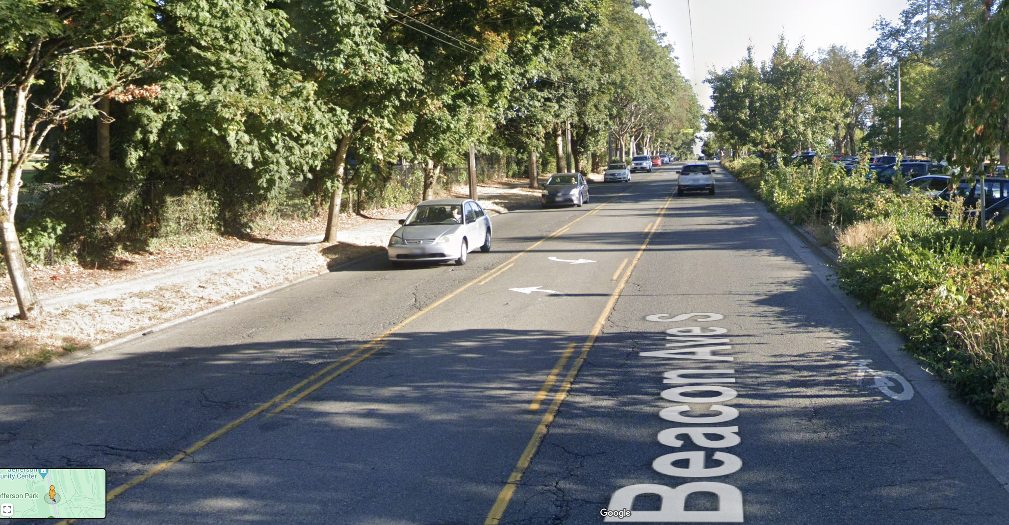
Looking at the plan for Beacon Ave S, it looks great. It calls for protected bike lanes the entire length of the road, which is great. But confusingly, the map notes it as an upgrade from an existing facility when there are no bike lanes at all currently. I think they may be counting sharrows as a bike facility. Because it may have an impact when prioritizing projects, any project on a street with only sharrows should be considered a new facility, not an upgrade. A quick glance reveals a bunch of these around the city (Boyer Ave E and 1st Ave S, are two obvious examples that jumped out immediately). This is a technical fix worth requesting. I think it is safe to say that this sharrow is not providing any value worth factoring into the 2024 plan:
The next issue that jumped out to me on the map is Seward Park Ave S. This is part of the Lake Washington Loop bike route, which is a major regional bike route. The lack of a bike+ facility here also leaves an enormous hole in the proposed bike+ network that has no rival anywhere else in the city. It is currently listed as a non-bike+" facility, which means it is an important connection for people bicycling and using e-mobility devices, but right-of-way is so constrained that an AAA [all ages and abilities"] bike facility is not feasible," according to the STP. Most of this non-bike+" section is about 30 feet wide with either two 15-foot lanes or two 11-foot lanes plus an 8-foot parking lane. The Route 50 bus runs on the street north of S Othello Street. Bike lanes barely don't fit unless you start fudging the standards for both general purpose lanes and protected bike lanes. So the plan concludes that they are not feasible with the current width, though SDOT will seek to make future improvements that support bicycling even though it is not feasible to design them for all ages and abilities." The plan also notes that should it become feasible to build bike+ facilities in the future, these roadways are not precluded from receiving AAA facilities." Council should consider ways to raise the priority of this connection or perhaps even challenge the non-bike+ designation. There is space to make an AAA bike connection on this street, though it will require some creativity since standard one-way bike lanes with protected buffer spaces and 11-foot general purpose lanes may barely not fit. The city's plan for 15th Ave S on Beacon Hill could be a guideline. It would be a bad outcome if this street failed to rise in the priority list because the STP says it would not make progress on the city's bike+ network goals. This street is too important to the neighborhood and to the regional bike network to allow it to fall through the cracks.
S Graham Street is also listed as a non-bike+ route between Rainier Ave S and Swift Ave S. There are parts of Graham that are skinny, but there are also parts that are plenty wide for a bike+ facility, including the very important stretch between the upcoming light rail station on MLK and the destination cluster on Rainier Ave S. The Council should suggest changing the designation to Bike+ at least for the wider section between MLK and Rainier. West of MLK, the street shrinks to less than 30 feet in width, though the connections to the Chief Sealth Trail and bike lanes on Swift Ave S are still important.
Speaking of the Chief Sealth Trail, the STP downgrades some crossings and segments that were marked as completed in the 2014 plan, which is a good thing. There are still a lot of little gaps and poor crossings that need work along the trail. It also adds a tier 1 catalyst project to fill the missing gap in the Chief Sealth Trail between Myrtle/Othello and Webster to connect schools and housing to the urban village." This is a great addition to the plan, and worth giving extra priority if possible. The plan also adds a Hail Mary of a tier 2 catalyst project that would continue following the utility corridor to connect the trail across I-5 and to the soon-to-be-constructed Georgetown to Downtown bike lane on 6th Ave S.
In fact, the plan adds a lot of catalyst projects along I-5, essentially saying that the city should pursue any I-5 crossing opportunity that arises. Any of them would likely be expensive and complicated and would require a partnership with WSDOT, but Beacon Hill has very long stretches where there are no crossing opportunities at all for people walking or biking, and the few that do exist are of very poor quality. This is a relic of redlining and a freeway construction era that was either indifferent or openly hostile to communities of color, and one result is that Beacon Hill was given far fewer freeway crossings compared to whiter and wealthier neighborhoods up north. The city and state need to invest to heal divides like these.
In all, there are a lot of good things in this plan, and biking in the southend would be dramatically easier and safer if the city builds them.
Let us know in the comments below what you notice about this plan for S/SE Seattle or if I missed anything.