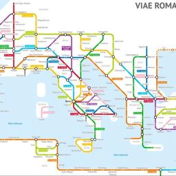
The Roads of Ancient Rome Turned Into a Modern City Subway Map

View this post on Instagram
Sasha Trubetskoy of Sasha's Maps turned the roads of ancient Rome circa 125 AD into a modern city subway map using information from the Stanford ORBIS model, The Pelagios Network, the Antonine Itinerary, and a little creative license.
It's finally done. A subway-style diagram of the major Roman roads, based on the Empire of ca. 125 AD. The lines are a combination of actual, named roads (like the Via Appia or Via Militaris) as well as roads that do not have a known historic name (in which case I creatively invented some names).
Trubetskoy explained that while the map was a passion project, it was not practical for the Romans of the time to use roads.
How long would it actually take to travel this network? That depends a lot on what method of transport you are using, which depends on how much money you have. ...However, no sane Roman would use only roads where sea travel is available. Sailing was much cheaper and faster - a combination of horse and sailboat would get you from Rome to Byzantium in about 25 days, Rome to Carthage in 4-5 days.
via Jeffrey Zeldman