An Incredible 3D Raised Relief Map of Westeros From ‘Game of Thrones’
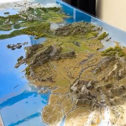
Over several months, cloakmaker Christopher Clarfin built an incredible 3D raised relief map of Westeros, the fictional continent in theGame of Thronesuniverse, as described byGeorge R.R. Martinin his A Song of Ice and Fire series. The project almost got the best of him, but still, he persisted.
I am building a giant map of Westrose with microscopic landmarks and geographic features ...And this is a project that's so ambitious I almost quit multiple times.
Throughout the entire process, Clarfin shared how he created various topographical features across the terrains, used resin for waterways, and employed 3D printing for the buildings.
Printable Castles I sculpted myself:
- The Wall + Castles
- Driftmark
- Pike
- The Fist of the First Men
- White Harbor
- The Dreadfort
- HarrenHall
- The Eyrie
View this post on Instagram
subscribe to the Laughing Squid Newsletter
The post An Incredible 3D Raised Relief Map of Westeros From Game of Thrones' was originally published on Laughing Squid.