 |
by Press on (#2NTH7)
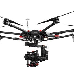
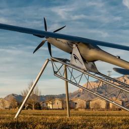
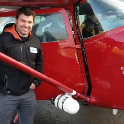
Phase One Industrial, the first to deliver 100-megapixel medium format aerial cameras, today announced full integration of its iXU and iXU-RS aerial cameras with DJI’s M600 and M600 Pro drones. Built using DJI’s SDK, this is the latest drone platform supported by Phase One Industrial, as it continuously innovates inspection tools uniquely capable of addressing […]
|
sUAS News
| Link | https://www.suasnews.com/ |
| Feed | http://www.suasnews.com/feed |
| Updated | 2026-07-21 03:15 |
 |
by Press on (#2NTGB)
Parrot is expanding in the commercial civil drone industry since 2012 via stakes and acquisitions in selected companies such as AIRINOV, MicaSense, Pix4D, senseFly as well as the creation of its specialized UAV service platform Air Support. The Group is combining a range of advanced and renowned solutions bringing high-value data and models meeting the […]
|
 |
by Press on (#2NS7R)
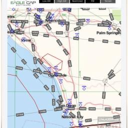
Aviation Charting Service (ACS) by Eagle Cap Software includes the tools and software necessary for operators and developers to add an aeronautical chart display—based on ARINC 424 data—to their ground control station (GCS) or situational awareness maps in order to facilitate beyond line of sight operations (BLOS). According to Dane Winchester, Co-Founder of Eagle Cap […]
|
 |
by Press on (#2NS7T)
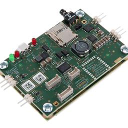
The AsteRx-m2 and AsteRx-m2 UAS OEM boards were launched today by Septentrio, a leading manufacturer of accurate and reliable GNSS solutions. These two new OEM boards which bring the latest in GNSS positioning to the market with unmatched interference mitigation technology all on ultra-low-power. The credit-card sized AsteRx-m2 and the AsteRx-m2 UAS offer all-in-view multi-frequency, […]
|
 |
by Press on (#2NS65)
This collaborative technology will detect gas and gamma radiation aerially to increase safety, improve mobility and streamline data analysis for professionals. Aerialtronics, a Netherlands-based commercial UAS manufacturer, and RAE Systems BeNeLux, a provider of gas and radiation detection systems, have announced an integrated technology partnership that will help keep professionals and the public safe from […]
|
 |
by Press on (#2NQ33)
The European Aviation Safety Agency (EASA) published today a proposal to regulate the operation of small drones in Europe. All interested parties are welcome to comment this proposal from 12 May until 12 August 2017. The proposal provides a framework to safely operate drones while allowing this industry to remain agile, to innovate and continue […]
|
 |
by Press on (#2NNK7)
Tata Consultancy Services (TCS) (BSE: 532540, NSE: TCS), a leading global IT services, consulting and business solutions organization, has opened its first Drones Research Lab in the US at its Seven Hills Park Innovation Center located in Cincinnati, OH, to address the rapidly expanding demand for unmanned aerial vehicles and business solutions across industries. The […]
|
 |
by Press on (#2NNK9)
Fortem Technologies, Inc. announced the close of an additional $5.5M round led by Signia Venture Partners and Data Collective (DCVC). Fortem Technologies, Inc. provides advanced radar systems and associated software systems for manned and unmanned aircraft as well as its own modern air defense system known as the Fortem DroneHunterTM. The Fortem TrueView Radar model […]
|
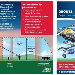 |
by Gary Mortimer on (#2NMDT)
My alma mater, RAF Shawbury has produced a handy drone safety leaflet. It points out where operators might more likely find themselves in conflict with manned aircraft within low flying area 9. That is a region that surrounds several airfields connected with joint services helicopter flight training in central England. It is a tidy document, […]
|
 |
by Press on (#2NM6J)
Mobilicom has announced the release of the SkyHopper PRO UAV Data Link – the first in its SkyHopper family of products. This advanced commercial UAV communication system addresses mining & process industry, infrastructure inspection, security and surveillance, and delivery drone applications. SkyHopper PRO also offers the unique advantage of its ability to deliver technology on […]
|
 |
by Press on (#2NJM8)
The Valmie Resources Inc. (OTCBB: VMRI) team headed to Nevada this week where it conducted a successful test flight of one of the five commercial base units the company purchased from ALTI UAS. The test flight was held in conjunction with Praxis Aerospace Concepts (PACI). Valmie will be incorporating five of the featured aircraft as […]
|
 |
by Press on (#2NHNM)
We are searching for an entrepreneurial International Human Resources Manager to join our rapidly growing team. You will be responsible for providing human resources services to our offices worldwide in alignment with our policies. This position is located in Lausanne, Switzerland. Pix4D develops internationally-renowned software products which are designed to make drone-mapping for professionals more […]
|
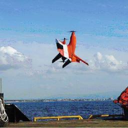 |
by Press on (#2NH8J)
On April 28th, the Swift 020, the first UAS featuring X-Blade Technology™ had a successful completely autonomous marine flight test excursion off the coast in Orange County, CA. The test, one in a series conducted by Swift Engineering, consisted of 8 consecutive fully autonomous launch and recoveries off a boat with an aft deck of […]
|
 |
by Patrick Egan on (#2NEX8)
On behalf of the readership and community at large we decided that Mr. Miller should be recognized for his leadership in the commercial drone industry. One of the cornerstones of any industry is insurance. Without insurance, you can’t have financing or work in entertainment, construction, mining, energy or any other field that indemnifies itself against […]
|
 |
by Press on (#2NDKG)
Thirteen university student teams from across Canada competed in the Flying Phase of the 9th Unmanned Systems Canada UAS Student Competition hosted by Centre d’Excellence sur les Drones (CED) in Alma QC from 28 – 30 April. Congratulations to the winner, University of Toronto – UAV Division. The purpose of this annual competition is to […]
|
 |
by Press on (#2NCGY)
Gene Engelgau With new and stricter drone safety regulations being implemented around the world much of the sUAS market is now waking up to the idea that safety does matter. Aeromao has been on board since 2011, much earlier than most UAV companies. With new and stricter drone safety regulations being implemented around the world […]
|
 |
by Press on (#2N9RJ)
Consortiq is seeking to recruit a Unmanned Aircraft Qualification (UAQ) course instructor with an interest in the dynamic and rapidly growing drone industry. With a significant presence in the United Kingdom, we are establishing a foothold in the United States drone training and integrated drone solutions markets. As such, we are seeking applicants who share […]
|
 |
by Press on (#2N9QF)
Drone technology is relatively new – but the clear success of drone implementation has led to rapid adoption in the energy industry. Leading commercial drone manufacturer MMC has now completed over 300,000KM of power line stringing across the globe. Tested in the dramatic landscapes of mountains across the Asian continent, rainforests in Indonesia, and challenging […]
|
 |
by Press on (#2N9QH)
Kespry, the leading aerial intelligence platform provider, announced today that technology industry veterans Jitender Aswani, Jim Allison and David Shearer have joined the company to deepen its leadership team as customer adoption and market momentum accelerates globally. Aswani joins the company as vice president of products and analytics. He brings twenty years of experience guiding […]
|
 |
by Press on (#2N9K9)
The new customer service of the German engine manufacturer is called 3W Engineering Services. This will not only be offered to existing and new 3W customers, but also to third-party customers and includes various service, test and measurement activities relating to engines and drive units and their further development. Since the increased demand for complete […]
|
 |
by Press on (#2N8B8)
Altavian is looking for a passionate data analyst to assist in photogrammetric data processing and organization on a part-time basis. The successful candidate will turn raw drone data into processed information, information into insight, and insight into business decisions for data customers and internal process development. Data processing analysts are responsible for routine photogrammetric data […]
|
 |
by Press on (#2N88E)
These past several months, our engineers have been busy testing Unmanned Aircraft Systems (UAS), or drones, on commercial 4G LTE networks at the Qualcomm UAS Flight Center in San Diego — testing key performance indicators (KPIs) such as coverage, signal strength, throughput, latency, and mobility under various scenarios on commercial LTE networks. Today, we are […]
|
 |
by Press on (#2N6XX)
senseFly, the world’s leading producer of mapping drones, today announces senseFly Corridor, a new platform enhancement that vastly simplifies the drone (UAS) mapping of linear infrastructure and sites. Corridor mapping is a common task for many geospatial professionals and crucial for the effective planning, design and analysis of linear infrastructure, as well as the monitoring of […]
|
 |
by Press on (#2N6PJ)
There has been a lot of discussion in the past couple of years about just what the right technology is for tracking the swarms of drones coming our way in the next decade. Because uAvionix is a communications, navigation, and surveillance (CNS) company focused almost solely in the drone industry – we are wrapped right […]
|
 |
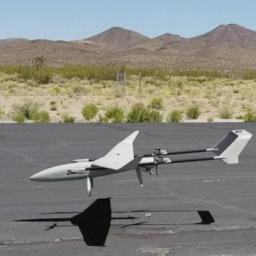
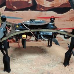
by Press on (#2N6MY)
On 24 October 2016, the operator (pilot) of a Lockheed Martin Stalker eXtended Endurance (XE) unmanned aerial system, configured in vertical take-off and landing (VTOL) mode, prepared to conduct a demonstration flight at Mount Disappointment, Victoria. The previous day, the operator had loaded the latest autopilot software onto the aircraft’s main autopilot. One mission goal […]
|
 |
by Press on (#2N48Y)
Representatives from FAI gathered with experts and organisers from around the world to exchange experiences from the recent past years and to discuss upcoming drone racing events in 2017/18 and plans beyond on a global level. Topics on the agenda saw a report from the FAI on its role and involvement in international developments on […]
|
 |
by Press on (#2N47D)
Silent Falcon UAS Technologies, a manufacturer of long range, long endurance, silent, solar-electric powered UAS, announced today it has partnered with Ascent Vision, specialises in precision-imaging Gimbal Sensor Technology, making Ascent Vision their preferred supplier of gimbaled payloads. “The Silent Falcon UAS can easily integrate a wide variety of payloads, and we’ve integrated five (5) […]
|
 |
by Press on (#2N47F)
Today, we are happy to announce our Pix4Dmapper Desktop 3.2 release. The new version has great advancement in stability and usability – Upload desktop projects to cloud is now 10x faster; Camera parameter correlations are displayed in the quality report for easier troubleshooting and assessment; New key output: tiled level-of-detail mesh is available in osgb […]
|
 |
by Press on (#2N2ZW)
HAZON Solutions (“HAZONâ€), the national leader in drone inspection services, announced today the launch of the HAZON Drone Management System (HAZON DMS). HAZON DMS is a secure, web-based management tool providing every drone operator, whether a hobbyist with a single drone or a large corporation with hundreds of drones, a way to safely and efficiently […]
|
 |
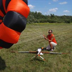
by Gary Mortimer on (#2N2E3)
Skyline UAV based in Australia are now offering a UAV Banner Towing service. This is something a friend of mine has done with real helicopters over London and it’s a right faff with amusing outcomes when you have to cut away. This goes straight into my very impressed folder. If you know flying wings you […]
|
 |
by Press on (#2N254)
Edgybees, an augmented reality technology company, Tuesday launched a new augmented reality (AR) mobile application that is compatible with DJI drones, including the Phantom 3, the Phantom 4 and the Mavic Pro. Developed using DJI’s software development kit, the ‘Drone Prix’ is the first ever AR mobile app created specifically for DJI’s aerial platforms, allowing […]
|
 |
by Press on (#2N23C)
British-based expert drone consultant, Consortiq, is securing its global status as it announces the opening of its new office in America. Based in Annapolis, Maryland, this strategic move allows the company to neighbour Washington D.C, a central East Coast drone innovation hub. Sending its aerial expertise overseas, this new expansion enables it to work closely […]
|
 |
by Press on (#2N1J9)
Starting January 1, 2020, you must be equipped with ADS-B Out to fly in most controlled airspace. Download the Equip ADS-B Google Earth map to look at the location of ADS-B rule airspace at your home base and where you fly. Pan and zoom to different locations and turn on the various capabilities the map […]
|
 |
by Press on (#2N0DM)
DroneDeploy is the leading drone software platform, enabling customers in farming, construction, and mining, to understand the world from the air. We’re a small and dynamic team, taking on the hardest engineering problems in the industry, while maintaining a clean and accessible design. We’re looking for a lead designer to help us build out and […]
|
 |
by Press on (#2N0C8)
Northwest UAV is now developing a NW-88 Twin-Cylinder Multi-Fuel Engine for 2017. Using design elements from the NW-44 Engine, the NW-88 Engine will bring the world class NWUAV reliability and efficiency to a new category of aircraft. McMinnville, OR: Northwest UAV (NWUAV) has initiated development of their new NW-88 Twin-Cylinder Multi-Fuel UAV propulsion system based […]
|
 |
by Gary Mortimer on (#2MZXB)
A big fanfare from around the world last week as Kevin Finisterre revealed that DJI had initiated no-fly zones for war-torn areas. DJI drones are being used to drop primitive ordinance with deadly results. Fast forward one week and CNN reporter Gabriel Chaim used the old tinfoil trick to cover the GPS on his DJI […]
|
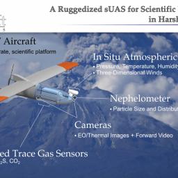 |
by Press on (#2MZN9)
With a legacy of delivering reliable, robust, and highly accurate small Unmanned Aircraft Systems (sUAS), NASA has awarded Black Swift Technologies (BST), a specialized engineering firm based in Boulder, CO, the contract to develop and deliver a purpose-built scientific platform to explore volcanoes in order to improve air traffic management systems and the accuracy of ash fall measurements. BST […]
|
 |
by Press on (#2MZA8)
IBM (NYSE: IBM) today announced that its inventors have been granted a patent for transferring packages between drones during flight. The invention described in US Patent No. 9,561,852: In flight transfer of packages between aerial drones helps to extend the range of drones that are delivering packages from a warehouse to a customer’s home. IBM […]
|
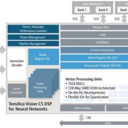 |
by Press on (#2MZAA)
Cadence Design Systems, Inc. (NASDAQ: CDNS) today unveiled the Cadence® Tensilica® Vision C5 DSP, the industry’s first standalone, self-contained neural network DSP IP core optimized for vision, radar/lidar and fused-sensor applications with high-availability neural network computational needs. Targeted for the automotive, surveillance, drone and mobile/wearable markets, the Vision C5 DSP offers 1TMAC/sec computational capacity to […]
|
 |
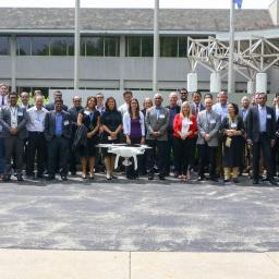
by Patrick Egan on (#2MYB7)
Speaker Series happening May 4th & 5th Golden Gate Club, 135 Fisher Loop, Presidio, San Francisco, 94129 This year’s line-up will deliver more top-notch content for the drone businessperson. Among the roster of drone experts and news makers this year are Kevin Finisterre, Department 13 (who just broke the world wide DJI Syria and Iraqi […]
|
 |
by Patrick Egan on (#2MWMD)
Pix4D is the main provider and industry standard for professional drone photogrammetry software. Pix4D is a dynamic and rapidly expanding company with headquarters in Lausanne and local offices in San Francisco and Shanghai. Pix4D is the only solution providing desktop, cloud, and mobile solution for drone mapping. You can find many professionals describing their use […]
|
 |
by Press on (#2MWJ1)
Unmanned aerial vehicles (UAVs), or drones, have gone in just a few short years from something associated solely with the military to being tested for Amazon Prime delivery, having a starring role in a Super Bowl halftime performance and being used by everyday people for basic flying fun. If there’s been one segment of the […]
|
 |
by Press on (#2MPK2)
What could happen if a drone hit a person on the ground? What’s the risk of serious injury? Can those risks be reduced? Although the Federal Aviation Administration (FAA) can’t yet definitively answer those questions, studies by a consortium of leading universities through the Alliance for System Safety of UAS through Research Excellence (ASSURE), have […]
|
 |
by Press on (#2MP74)
A volcanic archipelago in the Central Pacific of only 11,000 square miles, Hawaii has seen sustained economic growth for the last few years, and a record-breaking pace for the tourism industry. Construction benefits from this growth with an increasing need for infrastructure. Hawaiian Dredging Construction Company (HDCC) is the oldest and largest general contractor in Hawaii. […]
|
 |
by Press on (#2MNWT)
Skeye have signed a GeoXphere Market Partner agreement to use and distribute XCAM in the UK, expanding on their UAV capabilities. We are pleased to announce that Skeye has been appointed the GeoXphere Market Partner for the United Kingdom. They will be leading the capture of aerial photography using the revolutionary XCAM. This complements and […]
|
 |
by Press on (#2MM3V)
We are excited to announce that 3DR has recently raised $53 million in capital as part of our Series D funding round. This round includes both new equity and conversion of debt equity. It was led by Atlantic Bridge, and with investments from the Autodesk Forge Fund, True Ventures, Foundry Group, Mayfield, and a number […]
|
 |
by Press on (#2MKYJ)
Matt Fanelli Senior Manager for Strategy at Skyward One of the most staggering statistics that the Federal Aviation Administration revealed at a recent UAS Symposium was that businesses submit more than 3,000 Part 107 waiver requests per week. So it’s no wonder that it can take up to 90 days for requesters to get response—the […]
|
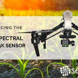 |
by Press on (#2MKTB)
Today, Sentera announced the release of its Multispectral Double 4K Sensor, offering five precise spectral bands: blue, green, red, red edge, and near-infrared (NIR). This sensor enables users to collect visual band imagery as well as vegetation indices based upon the addition of NIR or Red Edge, including normalized difference vegetation index (NDVI) and normalized […]
|
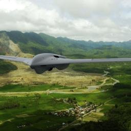 |
by Press on (#2MG17)
Lockheed Martin’s [NYSE: LMT] advanced tactical Group 3 unmanned aerial system (UAS), Fury, is regularly flying long-range endurance test missions as the company prepares it for low-rate production. In flight tests since May 2016, Fury has flown more than 200 hours and reliably demonstrated more than 12-hour endurance, while simultaneously operating 100 pounds of payloads, […]
|
 |
by Gary Mortimer on (#2MFMT)
If you can identify who flew and disrupted flights at Chengdu airport in April 2017, DJI might give you $145,000. No suprise that this press release does not seem to in English on the DJI site. It is below in all it’s Google translate glory. Some pressure must be being exerted on DJI at home. DJI […]
|