Support Waterfront Transit Lanes: Comment Deadline May 18

WSDOT Photo
Back in December we reported that the Office of the Waterfront would undertake a Supplemental Draft Environmental Impact Statement (SDEIS) to study removal of the planned bus lanes on the future Alaskan Way. There was some confusion at the time because no organized groups were agitating for such an outcome, and that all parties had generally agreed on the merits of transit priority. But the number of understandable complaints about the overall roadway width from bicycle and pedestrian advocates exceeded a threshold that triggered SDOT to study a narrowed footprint. From our followup post:
Office of the Waterfront Director Marshall Foster said the total number of comments asking for a narrower roadway hit "a tipping point" that forced the City to formally respond to their request, necessitating a SDEIS that studied a narrower roadway. However, Foster said the funding agreement between the State and the Port explicitly codifies two general purpose lanes in each direction, effectively prohibiting the City from studying reducing those lanes in the SDEIS:
Section II, A, 5: The Central Waterfront from Pine Street to Colman Dock will have two lanes in each direction plus a turning lane; the segment south of Colman Dock will have 3 lanes in each direction plus a turning lane.
So the City is in the odd position of being required to study a narrower channelization because enough of the community asked for it, but since the only mode not explicitly protected in its right-of-way allocation is transit, the City will study eliminating transit priority even though neither the City nor advocacy groups see that as a preferred outcome. Isn't process fun?
Well, that SDEIS has been published, and comments are due May 18. Read the full document here, or the Executive Summary here. And the results are a slam dunk. The SDEIS shows that removing the bus lanes would worsen travel times for transit, general purpose traffic, and freight.


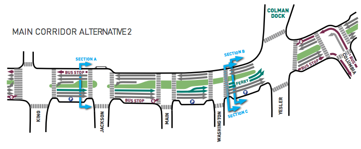
The SDEIS studied a new Alternative 2 that removes the bus lanes, adds a limited amount of street parking, reduces the roadway footprint by roughly 15% (from 88"^2 to 75"^2), and adds vegetation by widening the landscaping strips adjacent to the sidewalk and cycle track. There would be pullouts on the south side of the roadway for buses and/or street parking, with queue jumps added for buses to reenter the general purpose lanes. The narrower footprint would reduce walking time across Alaskan Way by approximately 7 seconds.
Vehicles
Alternative 2 would increase general purpose travel time by about 1 minute in each direction:
Main Corridor Alternative 2 would provide improved or additional facilities for motor vehicles, transit, bicyclists, and pedestrians in the study area compared to the No Action Alternative. However, traffic operations and intersection delays would be worse compared to Main Corridor Alternative 1. Under Main Corridor Alternative 2, removal of the transit-only lane and introduction of transit queue jumps at Yesler Way (southbound) and S. Main and S. King Streets (northbound) would reduce the amount of time the signal cycle is green for northbound and southbound general-purpose traffic. The reduced green time would result in worse travel times for all users, including transit, through the overall AWPOW study area for Main Corridor Alternative 2. These delays would cause greater congestion on Alaskan Way with Main Corridor Alternative 2 and result in traffic diverting to nearby streets. In addition, the lack of dedicated transit lane with, Main Corridor Alternative 2 would have reduced transit speed and reliability compared to Main Corridor Alternative 1.

Vehicular Travel Time Under the Two Alternatives
Transit
Removing the bus lanes has a worse proportional impact on transit. Even though transit will only use the half-mile strech from Dearborn to Columbia, delays would be double what general traffic would incur over the entire corridor. Bus trips would be roughly 2 minutes longer, reducing average speed from roughly 15mph to 8mph.
Both Main Corridor alternatives would improve conditions for transit compared to the No Action Alternative, but these improvements would be substantially greater under Main Corridor Alternative 1 than under Main Corridor Alternative 2. Main Corridor Alternative 1 would improve transit speed and reliability by providing transit-only lanes on Alaskan Way between S. King Street and Columbia Street, and a transit-only, southbound left-turn lane at the intersection of Alaskan Way and Yesler Way. Main Corridor Alternative 2 would not include these improvements, but would provide transit queue jumps at the intersection of Alaskan Way and S. King Street (northbound), S. Main Street (northbound), and Yesler Way (southbound). When the street grid is saturated during peak times or special events, buses would be caught in traffic longer for Main Corridor Alternative 2 compared to Main Corridor Alternative 1.

So if the SDEIS shows only a 7-second benefit for walking time while degrading travel times for all other users, Alternative 1 seems clearly preferable. Please comment by May 18 and speak up for transit priority. Though an 88"^2 street will admittedly feel anti-urban in many ways, the corridor's 30,000 transit riders deserve a fast, reliable trip.