DEIS Shows Two Options for Adding 95,000 Homes to Seattle
Last week Seattle released a much-anticipated draft of the environmental impact statement for the Mandatory Housing Affordability program, which allows developers additional height in exchange for building a certain amount of affordable housing.
Three scenarios were analysed: one taking no action, and two slightly different plans for distributing the increased development capacity around 27 neighborhoods in the city. All options would leave most single families areas unchanged. No action is expected to result in "substantially less affordable housing" and "less market-rate housing supply," according to the report. Alternative #2 implements zoning changes using existing growth patterns. Alternative #3 directs more growth to areas with a low displacement risk and easy access to transit, jobs and public amenities.
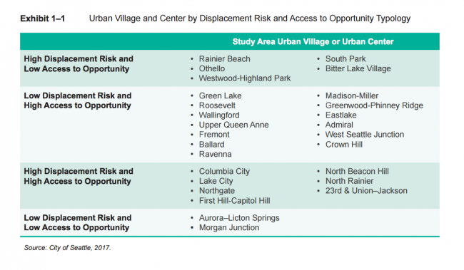
In other words, with alternative 3, neighborhoods such as Wallingford, Fremont and Ballard would see larger upzones and an expansion of the urban village boundary, allowing denser development, to areas within a 10-minute walk of frequent public transit. In the second plan, areas deemed to have a high risk of displacement and low opportunity, such as Rainier Beach or Othello, would receive less-dramatic upzones and smaller extensions of the urban village boundary.
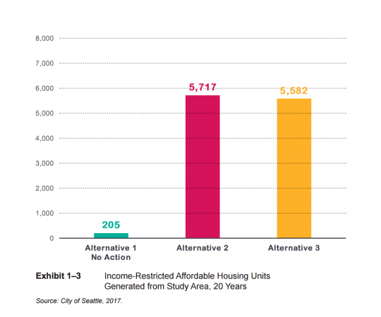
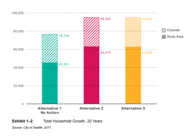
Implementing either proposal would create roughly the same number of affordable homes - estimated at 5,500 - and generate 95,000 total units of housing over the next 20 years. The plan of no action would generate only about 200 affordable units and 77,000 new homes, remaining consistent with the Seattle 2035 Comprehensive Plan.
With all scenarios expected to impact the region's transportation network, the report identified "reducing the share of SOV travel is key to Seattle's transportation strategy."
Transit boardings are forecasted to increase at least 74 percent in all scenarios, with light rail receiving most of that uptick. Slightly more boardings are expected with alternatives 2 and 3. No deficiency is expected, according to the report; as "It is reasonable to assume that Metro could add more buses to the busiest routes to accommodate some or all of the crowding."
For bus ridership, the largest increase is predicted for three routes: the 120 between West Seattle and Downtown, 40 between Northgate and Westlake, and 70 between Northgate and Downtown.
Pedestrian and bicycle trips are expected to increase under all alternatives but no significant impacts are expected as the Pedestrian Master Plan and Bicycle Master Plan move forward.
All alternatives are expected to increase traffic volumes across the city roughly the same, with several segments of Interstate 5, Interstate 90 and State Road 520 not meeting WSDOT's minimum LOS.
Three city corridors were predicted to see a decline in the level of service during the evening commute: southbound Martin Luther King Jr. Way from Rainier Ave South to the southern city limits; the Ballard Bridge going north; and 12th Avenue South between South Jackson St and Lakeside Avenue South.
The report suggests the City could simply accept a higher level of congestion on these streets consistent with other higher-density areas of the city. Instead, it could adopt mitigation strategies: increasing parking fees; modifying parking maximum limits; strengthening TDM requirements for new development to reduce SOV trips; purchasing additional bus service from King County Metro for certain corridors; and considering replacing or adding a bridge across the Ship Canal to add non-auto capacity.


