Federal Way Link Stations and Walkability
Edit, 11:40am, February 21: Sound Transit provided a newer map of the Federal Way Station area, reflecting a design change moving the bus terminal to be directly adjacent to the light rail station. The article has been updated with this information.
Since Federal Way Link is opening in 2026, here's a brief overview of the 3 stations opening next year and their layout. The diagrams are from the open house and photos from City of Kent and Sound Transit. The stations' existing poor walkshed will be improved with a new street grid. Biking to destinations east of I-5 will be moderately improved by new bridges, though new I-5 off/on ramps will also increase car to bicycle conflicts.
Kent Des Moines Aerial photo of Kent Des Moines Station by Sound Transit
Kent Des Moines Station is the first new station south of Angle Lake Station.
 Kent Des Moines Station map
The elevated Kent Des Moines Station will provide access to Highline College and surrounding neighborhoods and businesses. The station is elevated straddling over S 236th Street. There would be staircases and escalators both north and south of the new S 236th street.
 Kent Des Moines Station 3d model
The station will have three landscaped streets to promote easy access by walking, bicycling and transit. Two large plaza areas will feature landscaping, seating and public art. An additional plaza near the garage will include a covered seating area and space on the street for food trucks.
 Connectivity of Kent-Des Moines Station Map. Note the study is from 2014,
and the station location chosen is located a bit north of the actual station site.
The station would have decent connectivity west and south. Interstate 5 hinders traveling east. You'd have to go north to the Kent - Des Moines Road crossing, and if you're walking or biking to downtown Kent, KDM Road has an unsafe narrow sidewalk next to high-speed traffic.
 New Streets around Kent Des Moines Station by Kent Transportation Improvement Plan
 There are some plans by Kent to construct a new north-south 32nd Avenue S street from just south of Kent-Des Moines Rd to S 240th Street with bike lanes and sidewalks on both sides of the street. A new east-west trail would be built extending S 244th Street from SR-99 east to the new 32nd Avenue S street.
 I-5 and SR-516 map with WSDOT stage 1b project
The new SR-509 extension stage 1b would add wider sidewalks and a shared-use path on SR-516 under I-5. This will moderately allow for easier pedestrian and bike access across I-5.
On the other hand, the new southbound off ramp from SR-509 and new northbound ramp onto SR-509 will also increase car traffic on the under-crossing. The new Veterans Drive I-5 under-crossing is only for automobiles.
WSDOT has already almost finished construction of the previously mentioned stage 1b, but stage 2 is still in the planning phase (between 24th Avenue South in SeaTac and South 188th Street near the airport). There was a SR-509 stage 2 extension open house with more visualizations online.
Star Lake Star Lake Station is located just west of I-5 and north of S. 272nd Street by City of Kent
The Star Lake Station would be located just west of I-5 and north of S 272nd Street.

Located at the existing Star Lake Park-and-Ride site, the Star Lake Station features a 1,100-stall garage that will replace the existing surface parking lot. Sound Transit rebuilt a portion of South 272nd Street to improve vehicle/bus access (Route 183) to the station. Portions of 26th Avenue South and 28th Avenue South will have new sidewalks with landscaping. A pedestrian/bicycle path will connect the station plaza to the existing freeway bus stop.
 Star Lake Station 3d model imagesFederal Way Downtown
 Aerial view of Federal Way Downtown Station
Federal Way Downtown will be the new southern terminus.
 Edit, 11:40am, February 21: Station construction included moving the original bus terminal to adjoin the station, with a new bus layover area located east of the station (Sound Transit)
Located in the city center, the elevated Federal Way Downtown Station would serve several Sound Transit, King County Metro and Pierce Transit bus routes. A new street grid enhances access to the station and provides an opportunity for future development. The plots of land for construction staging will be converted to transit-oriented development (apartments) afterwards.
 Federal Way Downtown Station 3d model images
An expansion of the existing parking garage will accommodate an additional 350-stalls when the light rail opens.
 Federal Way Downtown Walkability Map
The Federal Way Downtown Station would have moderately good connectivity to the north, south, and west. A new street grid will help pedestrians reach the south-west a bit better. Connectivity to the east is mostly blocked by I-5 with the only path via S 320th Street.
 Federal Way Town Center 3 Map
Just north of S 316th, Federal Way has approved converting the Town Center 3 property ( former target site) into 1,600 units of housing as well as adding a civic plaza.
Commons Mall FutureThe Commons at Federal Way mall recently attracted Amazon Fresh and Dick's Drive-In. Future plans might include some infill 650 apartment units built in the Texas Donut" style with a parking garage in the center.
 21st Ave S and S 320 Street Signalized Pedestrian Crossing
A new signalized crosswalk along with a pedestrian refuge island could be built with realigned 21st Ave S.
 21st Avenue South pedestrian bridge concept
The Federal Way city council has also considered a more ambitious and expensive plan to trench South 320th Street under a 21st Avenue South pedestrian bridge. Some major complications are moving the utilities under the road.
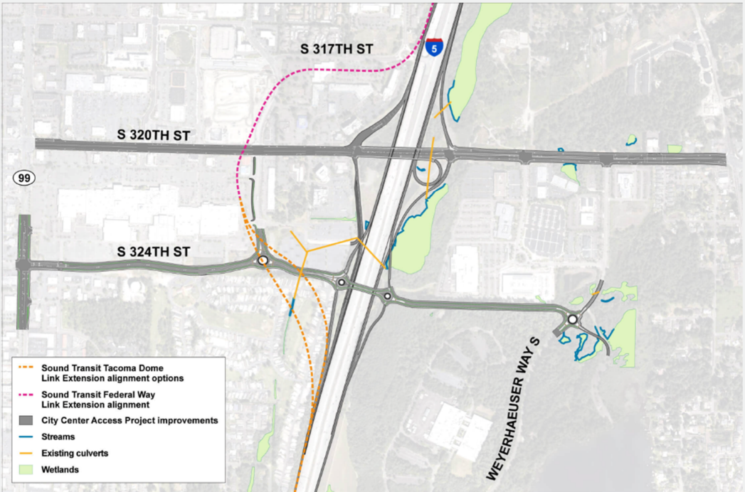 Federal Way City Access project map
The Federal Way City Access Project plans to add a new I-5 over-crossing at S 324 Street south of the existing bridge. While the main goal of the project is adding car access to and from I-5, the project will also add a new bike path to S 324th Street for bikers and add HOV lanes to the existing S 320 St bridge for bus routes 181 and 187.
While the project will add bike access to the east of I-5, it is a bit hard to label the project as unequivocally better for bikers considering the four on and off ramps planned at S 324th Street.
ConclusionThe Federal Way Link extension will help connect Kent, Des Moines, and Federal Way to Seattle and the rest of the Puget Sound Area. New street grids will help pedestrian connectivity for people to walk to and from retail and apartments. New freeway underpasses and bridges will provide new bike connections east of I-5 albeit with the corresponding increased car traffic.
Further Reading