Beyond the Freeway Edge: Center-Running BRT for Seattle’s suburbs
The Puget Sound metro area has made significant effort in expanding transit with both its light rail network and side-running BRTs like RapidRide and Swift. These have established a better transit baseline than many American regions have, enabling people to get around easier. Recent Link extensions like Lynnwood Link and the starter East Link, and future projects like Downtown Redmond, full East Link across Lake Washington, and Federal Way Link, are set to enhance regional connectivity. However, while these extensions are excellent for improving commuter routes and replacing express freeway buses, their freeway-adjacent alignment often bypasses significant job, retail, and residential hubs along existing avenues. This leaves many high-density corridors such as Aurora Avenue, Evergreen Way, Pacific Highway South and Rainier Avenue South underserved.
Enter - Center-running BRTs. Operating in dedicated lanes separated from general traffic, they offer a combination of moderate-high reliability, faster travel times, and relatively low cost compared to light rail. This makes them particularly well-suited for connecting dense urban corridors that are underserved by existing transit.
 SF's Van Ness BRT (picture from wikipedia)
 Richmond, VA's Pulse BRT
 Madison WI North/South BRT
Cities across the US have successfully have successfully implemented center-running BRT systems. San Francisco build the Van Ness BRT. Richmond, VA, built the Pulse BRT. Madison, WI implemented the North South BRT. These examples highlight the potential for center-running BRTs to complement existing transit networks and address gaps in service. They have quite long continuous sections with center-running bus lanes. They can still allow for two lanes of cars in each direction.
 Oakland's Tempo BRT
 Colfax BRT 3d render
For more constrained corridors, compact center-running BRT systems can fit into narrower 4~5 lane corridors. These still allow for one general lane in each direction with dedicated left/right turns. For example, AC Transit built the 9.5 mile Tempo BRT connecting Oakland, Fruitvale and San Leandro, CA. Denver, CO plan a 5.5 mile Colfax BRT connecting to Aurora.
Seattle itself also recently constructed Madison BRT on Madison Street with some portions of center-running bus lanes. But it does not quite reach the scope of the previous examples because it stays within the city borders and only travels 2.5 miles.
Corridors to Improve based on Ridership| Route | Weekday Boardings 2024 Oct | Route | Weekday Boardings 2024 Oct | |
| RapidRide E | 13,568 | Route 40 | 8,539 | |
| Route 7 | 11,314 | RapidRide C | 7,488 | |
| RapidRide A | 9,618 | Route 62 | 7,126 | |
| RapidRide D | 9,309 | Route 36 | 7,059 | |
| RapidRide H | 8,636 | Route 44 | 6,663 |
The top 10 King County Metro bus routes by ridership are listed above. RapidRide E, Route 7 and RapidRide A as the top 3 ridership routes are the best candidates to implement center-running BRT. Additionally Community Transit's highest used bus route Swift Blue with ~4,000 daily riders is also a good candidate to improve.
Swift Blue, RapidRide E, and RapidRide A are all on wide stroads that are easiest to convert to a center-running BRT. We'll start with upgrading Swift Blue from a right-side BAT lane BRT to a center-running BRT in this article. Other corridors will be discussed in future articles.
 Swift Blue (in blue) and RapidRide E (in red)
 Route 7 and RapidRide A (both in red)
Some of these top-ten routes and other bus routes have other long-term plans. RapidRide D parallels future Ballard Link. RapidRide H and RapidRide C will likely be replaced or truncated by West Seattle Link. Route 40 as a center-running tram (same alignment with center-running BRT) was already described in the Ballard Light Rail At-Grade article. Other high-ridership Sound Transit express bus routes are already being converted to the Stride (freeway) BRT.
Bus routes on medium-width avenues such as Route 7, Route 44, Route 36, and Route 150 were discussed in RapidRide prioritization plans. These will require a more compact center-running BRT alternative. Routes with a local+express pattern that are partly on a freeway such as Route 101/101 to Renton or Route 150 to Kent will require direct connectors between their centermost freeway lane and the arerial avenue they switch to.
Evergreen Way Center-running BRT (Swift Blue) Swift Blue Map
 Everett Link Extension Alternatives
The Everett Link extension runs along I-5 north to Mariner, then northwest along Airport Road, then east along Casino Road, before finally heading north along I-5. Community Transit's Swift Blue line runs from Everett on Evergreen Way via Lynnwood and Shoreline to Shoreline North station. Notably, the bus route skips Lynnwood City Center station in favor of remaining on Aurora Avenue.
A center-running BRT would provide fast frequent service on the areas skipped by Everett Link, and help complement the light rail line with connections both at the ends of the bus line with Everett Station and Shoreline North as well as in the middle with Airport Road and Evergreen stations.
Starting from Everett Station, the BRT would follow the existing path of Swift Blue heading west on Pacific Avenue and then heading south on Evergreen Way. The roadway of Evergreen Way north-east of SR-525 is 85~90 feet wide (~100 ft including sidewalks), wide enough for 3 general lanes and 1 bus/HOV lane in the center.
 Evergreen Way 100 ft with 3. general lanes and bus lane in each direction
 Evergreen Way at intersection widened to 120 ft with 3 general lanes, bus lanes, bus station and left turning lane.
The intersections would need to be widened by roughly 20 feet to maintain 3 general lanes, left turn and center BRT stations. Given that most of the corridor is lined with parking lots, while difficult it wouldn't actually be too cost-prohibitive to widen.
 Evergreen Way 100 ft with 2 general lanes and bus lane in each direction
 Evergreen Way 100 ft at intersections with 2 general lanes, bus lanes, bus station and left turning lane
Alternatively, if only 2 general lanes in each direction are required, construction would be much simpler. The existing center turning lane could be maintained while the centermost traffic lane could simply be repainted red. At intersections, there is just enough space for 2 general lanes in each direction along with a left-turning lane.
Lynnwood to Everett HCT study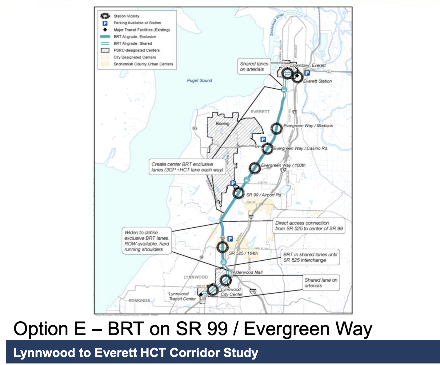 Lynnwood to Everett HCT BRT on SR 99 alternative map
The Lynnwood to Everett HCT study partially investigated such a center-running BRT on Evergreen Way. The study proposed 3 general lanes in each direction along with the center BRT lanes, somewhat validating that it is possible. However the alternative also proposed routing the line down a direct connector flyover from Evergreen Way to SR 525, then continuing south to Lynnwood City Center station (thus not serving Highway 99 south of Edmonds College). The line had wider station spacing than the existing Swift Blue line, 2~3 miles instead of 1~2 miles.
If the Everett Link extension is built, sticking with the existing Swift Blue alignment and closer stop spacing makes more sense. Riders heading to Everett or Lynnwood could instead transfer to the light rail, while shorter trips or those starting/ending on SR-99 could use the center-running BRT.
Evergreen Way BRT Travel time and Costs| From Everett Station | to Airport Road | to Aurora Village Transit Center | to Shoreline North station |
| BRT without traffic | 18 minutes | 39 minutes | 48 minutes |
| BRT with traffic (noon not morning) | 24 minutes | 53 minutes | 66 minutes |
| to Airport Road | to Lynnwood City Center | to Shoreline North station | |
| Everett Link | (estimated) 18~20 minutes | 34 minutes | 41 minutes |
A BRT would be usually be moderately slower than a grade-separated elevated light rail line, but the BRT in this case has the advantage of running straight down Evergreen Way, while the Everett Link detours to reach Paine Field. The current off-peak bus times for Swift Blue from Everett to Airport Road are about 18 minutes - the same as the light rail line. Reaching the Aurora Village Transit Center on the BRT would take 39 minutes without traffic (currently 53 minutes with traffic). Reaching Shoreline North station on the BRT would take 48 minutes without traffic (currently 66 minutes with traffic), while the light rail can reach Shoreline North in 41 minutes.
Evergreen Way BRT Density and Stop spacing Evergreen Way & 112th St SW
  Lynnwood Link Extension Freeway alignment density map
Evergreen Way is kinda auto-centric but it still has garden-style apartments along certain portions. The street is also relatively easy to infill in the future for further density. In comparison, the Lynnwood Link Extension and upcoming Federal Way Link Extension both stick close to the freeway with low density

The existing Swift Blue line runs for 16.7 miles with 18 stops, creating on average a 1 mile stop spacing in between stations. Unfortunately while an average 1 mile stop spacing is right on the verge of being unbearable, other sections have stop spacings of 1.5 or up to almost 2 miles around North Lynnwood.
Currently Community Transit minimizes the number of Swift Blue stations to decrease travel time and subsequently allow more buses to run the route at the same time. This allows for 10 minute frequency even with it's long length but heavily decreased access. Assuming the Everett Link Extensions exists for longer transit trips, the Evergreen BRT could stop more often near apartments and retail stores sacrificing a bit of travel time for access to destinations.
Evergreen Way BRT Costs and BenefitsThe cost of the center-running BRT with 3 general lanes might be relatively high, given the large intersection reconstruction at each station stop. There would be some property takings but generally only parking lots. The Option E from the HCT Corridor was studied at around ~$500 million dollars in 2015. The estimate can be used as a ballpark figure, given that we're adding an extension to Shoreline North station but subtracting the costly flyover to SR-525. Adding some inflation and post-COVID cost inflation construction would land an estimate around $700 million dollars.
For only maintaining 2 general lanes, the BRT would be much cheaper $300~400 million. The long length of the BRT line (17 miles) would typically involve massive utility relocation along the entire length. Given the relatively long stop-spacing distance, I suggest instead not adding physical barriers to the BRT line, and just painting the center lanes red. This would allow buses to detour around utility repairs in the center bus lanes by merging to the lane to the right and skip digging up the entire road. The BRT stations at intersections would require some utility relocation but not require any road expansion.
Citations