Who Would Ride Roosevelt-Eastlake BRT?

Atomic Taco (Flickr)
In debating the relative merits of transit and bike priority in the Eastlake and Roosevelt corridors, it's easy for each side to instinctively defend their own prior preferences. But largely unanswered in the debate so far is the fundamental existential question about the corridor, namely: How important is it from a mobility perspective, and for whom?
SDOT's continued prioritization of the corridor, and its inclusion in Move Seattle, goes against Metro's own planning instincts. Metro, having noted the poor off-peak performance of former Route 66, decided to break the corridor in two for the ULink restructure, and add peak-only service from Northgate (Route 63) and Roosevelt (Route 64) to South Lake Union to compensate. And we've already catalogued the dwindling importance of the corridor from a policy level, from the McGinn-era "rapid streetcar" dreams to the dangled possibility of real Bus Rapid Transit, to the current concept of modest improvements, electrification, and protected bike lanes.
So then, a question that needs answered: In 2021, which trips would be faster by bus, by Bus + Link, and by Link alone? With an educated guess of 20 stops in each direction, there are total of 380 possible trip pairs, and I won't analyze them all. Rather, I'll look at travel times for every southbound stop to each of the 6 major destinations along the corridor: Maple Leaf (75th), Roosevelt Station (65th), UDistrict (45th), Eastlake (at Lynn), South Lake Union, and Downtown.
One of the first things to note is that for all the proposed investment, baseline travel time would still be worse than today's scheduled times. Travel time improvements are relative to worsened baseline assumptions for 2021, not today's travel times. Nearly all of the congestion is between Downtown and the UDistrict, with a travel time of 40 minutes to travel 3.8 miles (an average speed of just 5.7 mph). The trip from Roosevelt to Northgate is projected to much speedier, traveling the final 3.4 miles in just 16 minutes (average speed of 12.75 mph). Average speed for the entire end-to-end corridor would be roughly 7.7 mph.
Link, of course, will be 5 times faster from Westlake to the UDistrict (8 minutes), 5 times faster to Roosevelt (10 minutes), and 4 times faster to Northgate (13 minutes). Average corridor speed between Northgate and Downtown will be roughly 35 mph. So it's clear from the outset that the bus corridor will serve primarily a shadow function, either connecting riders to their nearest Link station or facilitating trips between two in-between destinations (say, Eastlake to Ravenna Boulevard).
But from my attempt at a travel time analysis, assuming 6-minute frequencies on both Link and bus, it's even trickier than that. For most riders, Link alone, the bus alone, or a simple same-direction transfer between bus/Link will yield the fastest trip. But if the analysis is close to correct, there are several major trips for which a 3-seat ride (bus-Link-bus) or a backtrack (Link to bus) will be faster. Prominent among these are trips to South Lake Union from Northgate, Roosevelt, or even the UDistrict, for which backtracking from Westlake will save time. Others fast backtracks are Westlake to Maple Leaf (via Northgate), or Westlake to Upper Eastlake (via UDistrict Station). Trips from Maple Leaf to Eastlake or South Lake Union would be fastest via a 3-seat ride, using Link between UDistrict and Roosevelt in between two bus trips.
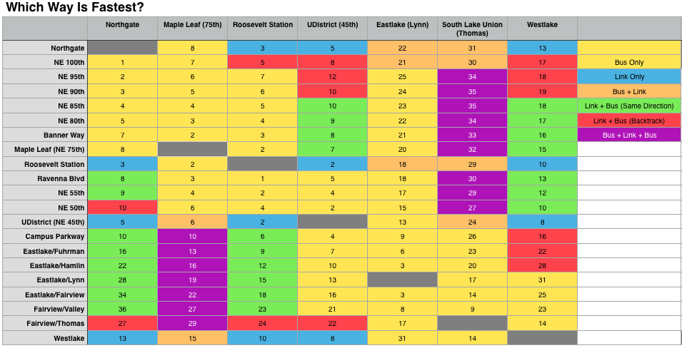
Despite a projected end-to-end bus travel time of 56 minutes, no trip on the corridor would need to take longer than 36 minutes. The only trips longer than 30 minutes are long trips originating in South Lake Union, Maple Leaf, or Eastlake. So the route would indeed be a local shadow and feeder service, with most trips involving a Link transfer along the way.
One of the defenses SDOT and select advocates have made for reduced investment is that short trips will predominate, with common trips of 1-2 miles saving only a minute or two for tens of millions in potential "full BRT" investments. The table above shows that this is indeed true, with very good travel times throughout the corridor at the proposed investment level, but only with Link's help. It is also clear that Eastlake and South Lake Union suffer most, with the most bus dependency and the slowest travel times, with only trips to Roosevelt or Northgate benefiting from a Link transfer.
Going forward, Eastlake will surely (and rightly) be a passionately contested corridor between bikes, transit, parking, and traffic interests. But though that is a legitimate debate, there is lower hanging fruit. Reducing the (frankly insane) amount of time budgeted to clear the Denny Triangle and South Lake Union (nearly half an hour in peak) would seem to be the highest imperative. This means continuous priority through the Mercer Mess, and possibly not using Stewart at all. Of course, all urbanists should ask SDOT to reduce the amount of parking between NE 45th and NE 65th. These are issues on which bike and transit advocates can and should find common cause.
In recent conversations, SDOT staff have told me they see Eastlake as "a bottle with two necks", implying that treating the entrance points (SLU and the University Bridge) is more important than Eastlake itself, where it is presumed that buses will move relatively well. SDOT also believes that "the bus will set the pace", with inline stops throughout and cars unable to pass. Done well, SDOT thinks this will strongly disincentivize through-travel, calm local traffic, free the bus to flow, and permit the installation of full-fledged protected bike lanes on a corridor for which building alternate bike facilities is cost prohibitive. Though I remain disappointed by some of the seemingly inevitable tradeoffs, after looking at trip times I'm tentatively inclined to agree, or at least understand where they are coming from.