Redmond Stations
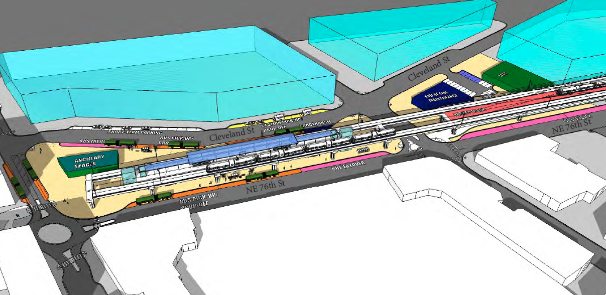
Redmond's preferred downtown station (Image: Redmond TRAIN study)
East Link to Downtown Redmond is scheduled to open in 2024, and the Sound Transit Board will update its preferred alternative on June 22. "Concept refinements" are now being considered. These are minor updates to the alignment including changes to station locations and the vertical profile of the guideway. Redmond last week approved a letter to the Board setting out what they hope to see.
In Downtown Redmond, a public process early this year considered four options: elevated vs at-grade, east (between 164th and 166th) vs west (between 161st and Leary). The Downtown Transit Integration (TRAIN) Study (large pdf), and public response, prefer the "East Elevated" option. That places the station opposite the Redmond Town Center parking garage. It allows easier bus-rail transfers because buses could approach both sides of the station, eliminating most street crossings for transferring riders. The shorter guideway for the East option reduces by several blocks the impacts to the Redmond Central Connector trail, and elevating the guideway eliminates vehicle and pedestrian conflicts if gates were opening every four minutes at peak.
Redmond's second ST3 station is in Southeast Redmond in the Marymoor area. Here, the city prefers an at-grade alignment. Both affordability and trail connection considerations figured in that choice.
In creating the ST3 financial plan, Sound Transit developed a "representative alignment" for the line. The ST3 representative alignment budgeted for one elevated station, though the assumption was for an elevated Southeast station and at-grade Downtown station. (Confusingly, the 2011 Record of Decision assumed both stations at grade). Building the station and guideway at grade in Southeast Redmond would save $110-$136 million vs. the ST3 budget. This easily accommodates the added $45 million cost of elevating the downtown station.
Unlike downtown which has already seen a lot of development in recent years, the Southeast station area is more of a blank slate. The low-value land uses in the area today are likely to be swiftly replaced. Either an elevated or at-grade station is consistent with other city goals for the station, but a lengthy aerial guideway through Marymoor Park would be costly. Generally, the guideway across SR 520 and through Marymoor must be entirely elevated or entirely at-grade.
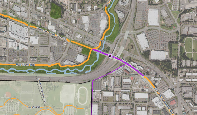
The heavy purple line indicates where the City would like to connect the East Lake Sammamish Trail and Redmond Central Connector (Image: City of Redmond). Click for full map.
An at-grade configuration for Southeast Redmond eases an important planned trail connection for the city. The downtown section of East Link follows the Redmond Central Connector, a former BNSF line through the city. The former rail line is truncated by SR 520 off-ramps to Avondale Road. On the other side of the ramps, the former rail line continues as the East Lake Sammamish Trail. Redmond would like to join these.
With light rail crossing the area of the ramps at grade, the ramps need to be rebuilt to accommodate the rail. That, fortuitously, makes it fairly inexpensive to add a trail connection alongside. With elevated rail, the aerial guideway would be high above the ramps and could not accommodate a trail connection. The trail would need either its own elevated structure, or the ramps would need to be rebuilt to fit a trail beneath. In the elevated rail scenario, the SR 520 modifications for the trail, whether above or below, would be costly and not offset by efficiencies from running the rail and trail together. That increases the potential cost of the trail crossing alone to up to $20 million. Redmond staff estimate the trail connection is not likely in the foreseeable future without a Sound Transit partnership.
With net project savings of $65-$91 million, Redmond anticipates Sound Transit will be pleased to accept the alignment modifications.
All the elevated concepts studied would completely separate vehicle and rail traffic. Most at-grade concepts also do so, excepting one concept that includes an at-grade rail crossing at the westbound on-ramp to SR 520 at NE 76th St. At-grade options in Southeast Redmond do add some temporary traffic impacts during construction because of the need to rebuild SR 520 ramps.
The City's letter also makes recommendations about the Southeast station area and parking. Redmond wants good non-motorized access from the station to Marymoor Park and the East Lake Sammamish Trail. The parking (1,400 stalls are planned) should be in multiple structures and wrapped with retail or other pedestrian-friendly uses.