A Belated, but Welcome, Proposal to Fix the Mount Baker Mess

Image via SDOT.
Last Thursday, SDOT's Accessible Mount Baker project manager Michael James-a youthful guy with an indifferently tucked shirt and an eager smile, presented an intriguing, but still unfunded, proposal to improve the transit, bike, and pedestrian connections around and between the Mount Baker light rail station on the west side of MLK and the Mount Baker Transit Center on the east side of Rainier.
The meeting, held in the windowless Kings Hall building behind the station, turned out a few dozen committed residents for tortilla wraps, a mixed-fruit platter, and a detailed discussion of what the station area might look like in the hands of SDOT's "Accessible Mount Baker" team.
Although the city hasn't identified any specific funding source for the project, expected to take up to a year to build, James said it was consistent with SDOT director Scott Kubly's vision for spending the money raised by the Move Seattle levy, an ambitious $900 million proposal that will, if voters approve it in November, be roughly twice the size of the 2006 Bridging the Gap levy it would replace.
Like Martin, I can attest that the Mount Baker rail station and the flat concrete expanse of the Mount Baker Transit Center across the street are underdeveloped, poorly connected, and confusing even to a longtime transit rider like myself.

SDOT
The transit center on the east side, which serves routes 7, 8, 9, 14, and 48, is separated from the light rail station by (let's just call it what it is) a broad highway; a nearby pedestrian bridge is circuitous, indirect, and steep, encouraging pedestrians to jaywalk and drivers to pick up speed. And the road configuration, with its turn lanes in both directions, increases pedestrian wait times and forces many to dash across the street so they won't have to wait a full three-phase light cycle.
It's little surprise, then, that Rainier and MLK have had several times the "acceptable" number of crashes over the past few years; between 2010 and 2013, there were 42 crashes at MLK and McClellan; 65 at McClellan and Rainier; and 76 at Rainier and MLK. The "acceptable" number, according to James, is 10 crashes a year.
The Seattle Department of Transportation has long acknowledged that the current situation is dangerous and untenable, producing 11 studies over 15 years to figure what might someday be done in the area. To their credit, as Matthew reported last week, they're finally trying to fix the problem-"focus[ing] on implementation, not just another study."
If SDOT's dream plan gets approval and funding, it will be a dramatic change for the better for Mount Baker neighbors and transit users. Instead of prioritizing north-south car traffic through the area, the proposal would help make Mount Baker "a to place, not a through place," as James put it -a focal point for community events, retail, outdoor activities, and new housing and jobs.
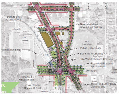
The draft proposal (which SDOT director Scott Kubly calls the "bolo tie," a reference to the "bowtie" concept that would have made Rainier and MLK one-way around the light-rail and bus stations) would eliminate the bottleneck at MLK and Rainier by getting rid of the intersection between the two streets. This would be done by effectively splitting both arterials and connecting the eastern and western halves of each. The northern part of Rainier Ave. would transition directly into the southern part of MLK and vice versa. There would a bus only connection between the two at Mt. Baker Blvd for the 7, 8, and 9X.

SDOT
That change would eliminate left turns between the two streets, creating a two-phase light cycle that would give pedestrians more time to cross. The Routes 7, 8, and 9 would still stop on Rainier but somewhat closer to the station entrance; the Routes 14 and 48, meanwhile, would stop to the west of the rail line and south of the station.
The proposal would also add open space, widen crosswalks, enlarge waiting areas, and move several bus stops closer to the station; a hot-off-the-presses map showing all of SDOT's proposed "Phase 1"^3 and "Phase 2"^3 improvements can be found here.
But keep your powder dry. Remember, this is an "if," not a "when," situation. SDOT still has come up with a long-term plan, get past the obstacles thrown up by the car lobby as well as neighborhood residents who oppose new development (and change). Reconfiguring the station area would also require tearing down the Philly's cheesesteak restaurant, a neighborhood staple, removing the pedestrian bridge, and repurposing the existing transit center. If all those changes win approval, SDOT would have to win a slice of highly coveted unprogrammed levy money-expected to be in the tens of millions of dollars-for the project, a process that will involve competing with many other worthy proposals.
On Thursday, James pointed out that the projects SDOT is proposing are all "exactly the type of projects that you've seen in our Move Seattle plan and, really, what our future levy is based on. Unfortunately," he added, "this [plan] wasn't at a place where we could actually put it in the Move Seattle plan or the levy." That may not inspire confidence or enthusiasm in you or me, but James has more than enough to go around.