Past Plans 1980s ~ 2000s
There's been some discussion about past plans such as Forward Thrust (1970s). However, many other plans were debated. The Link light rail could have ended up as a very different variant of light rail. This article will provide a brief overview of the past plans and some light commentary.
PSCOG 1986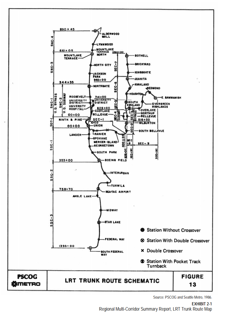
The general alignments in the PSCOG 1986 plans aren't too different from the eventual ST2 with a branched line heading from Lynnwood to Seattle and then either east via Bellevue to Redmond or south via Sea-Tac to Federal Way. However there are some notable differences with the exact route.
From Seattle to Tukwila, rather than running on Mlk Way, the light rail line ran on East Marginal Way then via the Interurban Ave S to reach Southcenter Mall. This route added stations at Boeing Field, South Park and Georgetown though at the expense of the Rainier Valley ones.
The Federal Way and Lynnwood Link segments generally are the same with an I-5 alignment. For East Link, the line was extended out to Sammamish past Redmond and there was an additional Bothell via Kirkland to Bellevue line.
Rhododendron Line 1992Some others advocated for a light rail similar to Portland's light rail. Called the Rhododendron Line, the line would run at-grade in the center of SR 99 via Tukwila International Boulevard and then Aurora Avenue with signal priority. The line would connect downtown Everett, Aurora Village, Green Lake, Woodland Park, Seattle Center, the Washington State Convention & Trade Center, the Kingdome, Boeing Plant 2, Sea-Tac Airport, the Tacoma Dome, and downtown Tacoma. The northern section would somewhat follow the Seattle-Everett interurban. The line would be closer to density but at the cost of speed compared to a freeway alignment.
1995 Plan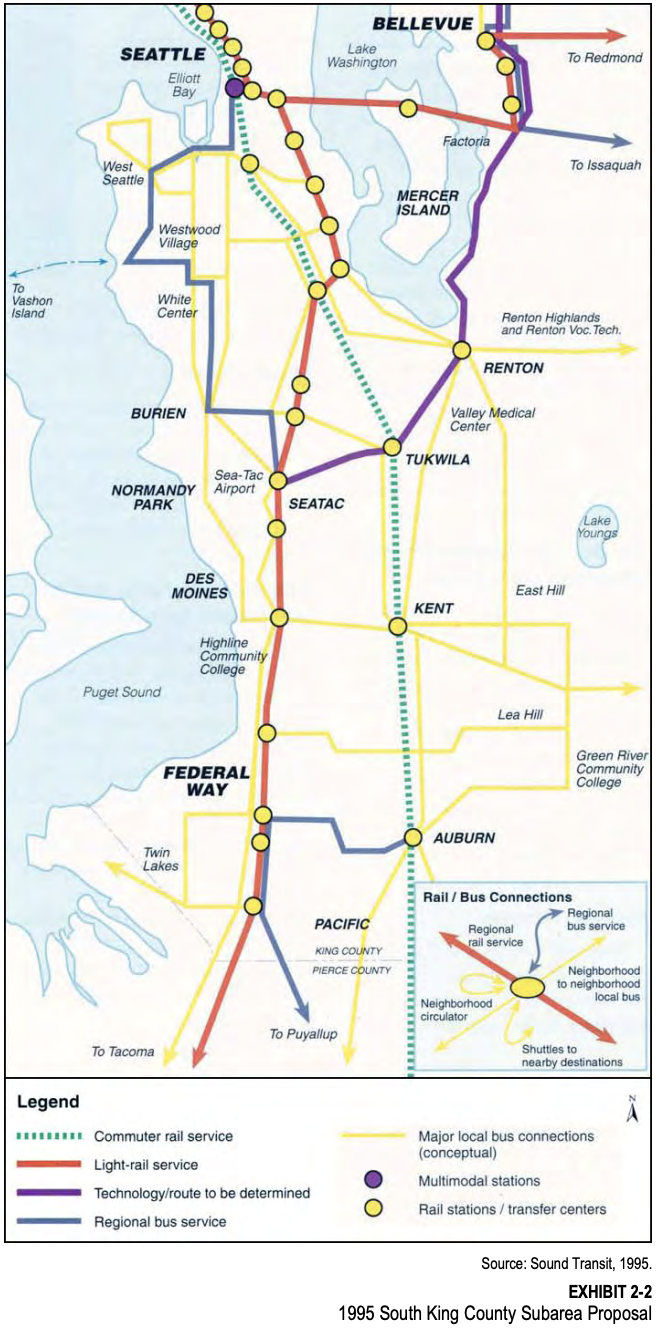
The 1995 RTA plan advocated routing the light rail through Rainier Valley on Rainier Avenue. The Federal Way alignment generally is the same as the Federal Way Link Extension. A separate Bellevue via Renton to SeaTac line using the ERC is shown in purple as well.
1996 Sound Move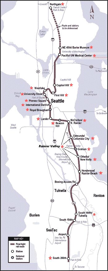
The 1996 proposed plan. Unsurprisingly pretty similar to what was built. Some differences are the missing Graham and First Hill stations. The Pacific UW Medical Center station was shifted next to the Husky Stadium and the Tukwila alignment shifted next to the freeway lost the South 145th station.
1997 Environmental Impact Statement on the Proposed Central Light RailWhile the 1996 section shows the map of the preferred alternative, the EIS provided two alternatives suggested for each segment of the corridor. From the Environmental Impact Statement on the Proposed Central Light Rail (1997). The list below highlights which alternative was built or not chosen. Note back then the light rail was envisioned to run at-grade for many more sections.
- SeaTac
- (Not chosen) One route follows International Blvd. (State Route 99) from S. 200th Street, north past Sea-Tac Airport to the intersection with SR-518.
- (Built) The other alignment starts from the samelocation at the south end of the City and follows 28th Street, usingSea-Tac Airport property traveling north to connect with the SR-99route.
- Tukwila
- (Not chosen) One alignment would use Pacific Highway South (State Route 99) between the SeaTac city limits and Boeing Access Road.
- (Not chosen) The second alignment would travel east from State Route 99 along State Route 518 and continue east past Southcenter Mall. The line would proceed north along Interurban Avenue to I-5 at Boeing Access Road.
- (Built not listed) Followed along I-5 instead
- Rainier Valley
- (Built) One follows Martin Luther King, Jr. Way from Henderson Street north to McClellan Street.
- (Not chosen) The other follows Rainier Avenue South between the same locations
- SODO/Little Saigon
- (Not chosen) One alignment would run north along Rainier Avenue past I-90, before heading west to connect with the existing International District tunnel station.
- (Built) The second alignment would explore the feasibility of tunneling under Beacon Hill, beginning just west of the intersection of Rainier Avenue and Martin Luther King, Jr. Way. The route would connect with the existing E-3 busway at South Lander Street and would travel north to the International District tunnel station.
- University District
- (Built but adjusted) One alignment is a tunnel beginning under I-5 east of the existing Convention Place tunnel station. The tunnel would loop south to serve First Hill, then continue north under Broadway Avenue and 10th Avenue East. The tunnel would continue under Portage Bay and 15th Avenue Northeast in the University District.
- (Not chosen) Another alignment would run north from the Downtown Seattle Transit Tunnel at the Westlake Station underground through the Denny Regrade and the Seattle Center areas. The route would continue northeast through south Lake Union and the Eastlake/Fairview area, adjacent to I-5. The route would leave the tunnel north of SR-520 and would cross the Ship Canal on a new high-level bridge parallel to the existing I-5 bridge. The route would continue east along Campus Parkway and reenter a tunnel under the University District.
Rail Route Creates Hard Feelings - Northern Cities, Rainier Valley, Tukwila Feel Slight
- The city of SeaTac: Although the trains are to have stations at South 154th Street, a new airport terminal and South 200th Street, SeaTac officials had hoped for an additional station near its city center. Sound Transit officials said that many stations weren't needed.
- Tukwila officials: They failed to persuade the board to reroute the trains to Southcenter.
- Cities in North King County. Officials from Kenmore, Bothell, Shoreline and Lake Forest Park: protested that since the trains weren't going to go as far north as Northgate, their citizens weren't getting anything for their tax money. They complained that they were being left out because they didn't have direct representation on the board.
- Rainier Valley residents: hoping for a tunnel instead of surface trains. Although there was public testimony about a tunnel, the board didn't bring it up. There is not one elected official willing to fight for our community," protested Michael Washington, a Rainier Valley dentist.
The Light-Rail Transit Plan - On Wrong Track?
| ... In 1992, the city persuaded planners to put the line through the Rainier Valley. Planners first discussed a subway through Southeast Seattle, but Johnathon Jackson, a Sound Transit manager for community relations, said local residents supported surface or elevated tracks to spur development. Those were the two options included when the transit plan was approved by voters in 1996. In 1997, Jackson said community groups and residents pushed to get the elevated-track option eliminated. Rainier Avenue business owners got the route shifted to the wider and less developed MLK Way. ... Others still favor the street-level system and are pleased by Sound Transit's promise of a $50 million community investment fund for Rainier Valley. |
Many have decried how Sound Transit built at-grade tracks in Rainier Valley with the slow speed and fatalities against community wishes. However, contrary to popular belief, Sound Transit actually first proposed a subway down Rainier Valley using Rainier Avenue. This was rejected in favor of at-grade or an elevated alignment. Sound Transit then proposed an elevated option which was again rejected by the community, leaving only the at-grade alignment.
2001 North Link Record of Decision
The record of decision for North Link discussed many different alternatives. The main ones differing majorly from the actually constructed Link will be listed here, while others similar to the preferred alternative will be skipped.
Various alternatives were proposed in UW with NE 45th station or Brooklyn station in the north side. For the south end of UW, Sound Transit proposed either Southwest Campus station, Pacific station, Montlake/Rainier Vista station, or the actually built University of Washington (Husky Stadium) station.
2002 Monorail Plan
Fed up with the slow pace of Sound Transit initiatives, others proposed the Seattle Monorail plan. The elevated monorail would travel from Ballard to Downtown Seattle via 15th Ave W. The monorail would travel through downtown via 2nd Avenue on center median columns before heading south on 1st Avenue towards West Seattle.
2002 WSDOT I-405 analysis HCT Alternative 1
For the I-405 corridor, while generally focused on freeway expansions WSDOT also analyzed multiple corridors for where to build fixed guideway transit. The Bellevue via Renton to SeaTac line from 1995 was detailed further, as well as an interesting interchange at Factoria for Issaquah's light rail. The Kirkland Link is extended north via Woodinville to Lynnwood. A bit more time will go into explaining this plan since WSDOT checked the feasibility of the route and provided detailed maps.

The south end of the line would interline with the Line 1 at Tukwila International Boulevard Station (similar to the Burien/Renton Extension). The line would then continue elevated east and then cross south of I-405 and then tunnel under I-5 to reach Southcenter. The line would then continue east to the Tukwila Sounder station and then transition to an at-grade profile. The line would continue at-grade in the Grady Way median until transitioning back to an elevated alignment until downtown Renton. The line would then head north until N 8th street transitioning back to an at-grade alignment, stopping at Sunset Boulevard, and then continuing north via the ERC until Bellevue.


The Seattle, Bellevue, Issaquah and Renton light rail had a very interesting interchange. An elevated Factoria station would have served all north/south/east/west directions as an X pattern. Trains from Seattle or Renton could head to Bellevue or Issaquah as well as vice versa. However, trains could not go from Issaquah to Bellevue (as currently planned) nor Renton to Seattle.
For East Link, the WSDOT plan had the light rail running on Bel-Red road on an aerial alignment instead of running on Spring Boulevard. The line would then head north and continue on SR-520 to Microsoft and then downtown Redmond.
For Kirkland, the light rail would continue north along the ERC at grade. The line at NE 68th Street would transition to an elevated alignment and head north up State Street to reach downtown Kirkland. The line would then head east on Central Way and then rejoin the ERC at-grade until Totem Lake.


North of Totem Lake, the line would continue aerial until re-entering I-405. The light rail would stop at Canyon Park on the north side of I-405 and then continue north along I-405 until rejoining the Lynnwood to Everett Link segment along I-5 at Ash Way station.
2008 East Link HCT Plan
From the East King County Subarea High Capacity Transit (HCT) Appendix N (2008) a couple different routes were analyzed for the potential East Link. The starter East Link constructed wasn't too different from the above map. However, for the South Kirkland to Issaquah Line notably it is extended north to Totem Lake via the ERC. Also the line would travel to Issaquah through South Bellevue station and then directly to I-90 rather than via the ERC. For Issaquah, the line (at-grade) would run on 17th Avenue and then Sunset Boulevard to reach downtown Issaquah.
2010 and beyondSound Transit for ST2 decided on the Lynnwood Link and Federal Way Link extensions. For ST3 Sound Transit decided on the alignments for Everett Link, Tacoma Link, West Seattle Link, Ballard Link and Issaquah Link. Others light rail line proposals such as Lynnwood via Bellevue to Renton Link were removed in favor of Stride BRT (freeway bus). The Ballard to UW tunnel and possible SR-520 light rail were briefly proposed. The West Seattle via Burien to Renton Link was too expensive for relatively medium ridership. Some other ST4 ideas were extending the Ballard Link north to Northgate and eventually to Bothell. These will possibly be detailed further in a future article.
Thought and ConclusionThere's been many past light rail proposals throughout the Seattle metro area. While currently Sound Transit is facing large cost overruns, hopefully in the future there's still much potential for light rail expansion to connect the region. The older plans used aerial and at-grade alignments instead of ridership poor at-grade freeway or incredibly expensive tunneled alignments.
References- Environmental Impact Statement on the Proposed Central Light Rail (1997)
- North Link Record of Decision (2001)
- Seattle Monorail (2002)
- I-405/SR-167 Corridor Plan (environment tab)
- WSDOT I-405 EIS Analysis (2002)
- WSDOT I-405 EIS Appendices (2002)
- Appendix M shows the detailed maps
- East King County Subarea High Capacity Transit (HCT) Appendix N (2008)