 |
by Press on (#362QW)
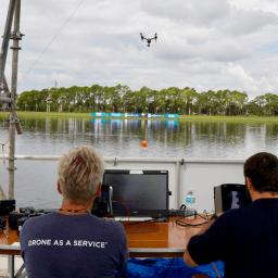
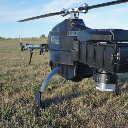
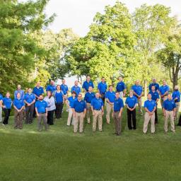
Researchers at Sandia National Laboratories recently flew a tethered balloon and an unmanned aerial system, colloquially known as a drone, together for the first time to get Arctic atmospheric temperatures with better location control than ever before. In addition to providing more precise data for weather and climate models, being able to effectively operate UASs in […]
|
sUAS News
| Link | https://www.suasnews.com/ |
| Feed | http://www.suasnews.com/feed |
| Updated | 2026-07-21 19:00 |
 |
by Press on (#362KJ)
DJI, the world’s leader in civilian drones and aerial imaging technology, Wednesday demonstrated two important new systems it has developed to help ensure drones remain a safe, secure and beneficial addition to America’s airspace. DJI’s new AeroScope system acts like an “electronic license plate for drones†and provides a reliable way for authorities to identify […]
|
 |
by Press on (#3623R)
WASHINGTON – President Donald J. Trump directed U.S. Secretary of Transportation Elaine L. Chao today to launch an initiative to safely test and validate advanced operations for drones in partnership with state and local governments in select jurisdictions. The Unmanned Aircraft Systems (UAS) Integration Pilot Program implements a directive signed by President Trump today, and […]
|
 |
by Patrick Egan on (#3623T)
The latest expose about the DAC in the Washington Post was an eye-opener that validates many of the misgivings some of us have had with the FAA’s private rulemaking process. First and foremost, it would appear that someone lobbying for a certain Chinese company has worn out his welcome. It is pure speculation as nobody […]
|
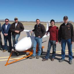 |
by Press on (#3620K)
Wallops Island – Vanilla aircraft completed a historic flight at the NASA Wallops Flight Facility and the Virginia Space UAS Runway located on the Eastern Shore of Virginia. On October 18th Vanilla Aircraft VA001 took off from the NASA Wallops Flight Facility and embarked on a historic long endurance test flight that landed safely more […]
|
 |
by Press on (#3620M)
HAZON Solutions (“HAZONâ€), the national leader in drone inspection services, and PrecisionHawk, a provider of advanced commercial drone technologies, announced a partnership today to integrate their technologies to provide better drone safety for commercial drone operations. Starting in early November PrecisionHawk’s Low Altitude Traffic and Airspace Safety (“LATASâ€) platform will be accessible within the HAZON drone […]
|
 |
by Press on (#3616B)
Black & Veatch and Aeryon Labs announced today that they have launched an end-to-end asset management inspection solution leveraging drone technology for global energy clients. Aeryon’s commercial unmanned aerial system (UAS) hardware, software and services enable the capture of critical infrastructure condition data that is integrated by Black & Veatch into a utility’s existing enterprise asset management (EAM) systems. […]
|
 |
by Press on (#360WK)
Azur Drones, the French pioneer in civil professional UAVs, has carried out a fourth fund-raising exercise of €3.5 million. It has now raised more than €10 million in funds over the last 12 months and, with Skeyetech, completes its third defining acquisition in nine months. The company is the French leader in UAV video-protection solutions […]
|
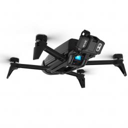 |
by Press on (#360P6)
The all-in-one drone solution for thermal imaging Parrot Bebop-Pro Thermal is an all-in-one quadcopter thermal imaging solution specifically designed for small construction businesses, thermal inspection professionals and public safety services. This solution enhances Parrot’s Professional range of business solutions, which launched earlier this year with Parrot Disco-Pro AG, Parrot Bebop-Pro 3D Modeling and, more recently, […]
|
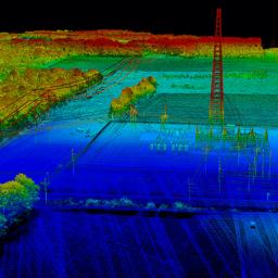 |
by Press on (#360P8)
Cloud-based LiDAR platform automates trajectory processing, making the technology more affordable and accessible Los Angeles, CA — October 25, 2017 — Addressing a major opportunity in the LiDAR industry, Phoenix LiDAR Systems has announced its LiDAR Mill platform, the first cloud-based, fully automated LiDAR post-processing tool. Historically, the large quantities of raw data generated by […]
|
 |
by Patrick Egan on (#35Y4S)
[Intro about lack of transparency at AUVSI. Board of Directors no longer elected, appointed instead, downhill slide of overall advocacy, etc….] But lately, I have grown rather confused. For example, I would like to highlight a series of letters from AUVSI that began in 2016. Rewinding to 2016, there was a debate in the U.S. […]
|
 |
by Press on (#35YDS)
Microdrones is excited to announce the release of a new professional aerial methane detection solution, the mdTector1000 CH4. It’s the newest fully integrated aerial methane inspection package built for professionals responsible for methane gas infrastructure. “For our customers, we want to provide the very best packages, with a full line of systems and payloads including the […]
|
 |
by Press on (#35Y4V)
UPTAKE OF DRONES and flying gadgets is soaring in those aged 50 and over, signalling the rise of the ‘silver soarer’. It is often assumed that stereotypically younger people tend to be the first to adopt new technologies, the majority of drone users in the UK (31%) are aged 55 and over, compared to just […]
|
 |
by Press on (#35Y4X)
New Division of Largest U.S. Drone Services Provider Headed By Industry Veterans, Including Emmy Award-Winning Aerial Cinematographer Eric Austin Measure, the largest U.S. provider of drone services for enterprise customers, today announced a new division to service the arts and entertainment industry, Measure Media (M2). M2 operates the first nationwide network of full-time drone pilots […]
|
 |
by Press on (#35Y4Z)
Consortiq has rolled out a series of new upgrades for its safety-led drone operations management software, CQNet, introducing a more user-friendly and intuitive version of the tool for easier and more efficient operations. New features include a modern mapping tool, an easier application interface, and a more streamlined process by which to access flight planning […]
|
 |
by Press on (#35Y1Q)
Blue Marble Geographics (bluemarblegeo.com) is pleased to announce that 4DMapper (4dmapper.com ), a geospatial technology company based in Australia, has chosen the Global Mapper Software Development Kit (SDK) as the engine behind its online data analytics services. The company’s innovative cloud-based approach to geospatial data creation and distribution reduces the need for their customers to maintain […]
|
 |
by Press on (#35XXY)
Cepton Technologies, Inc., a provider of 3D LiDAR sensing solutions for automotive, industrial and mapping applications, announced today the launch of SORA 200, its lightweight 3D LiDAR sensor, at the annual Commercial UAV Expo. SORA 200 delivers long-range, high-resolution and low-cost mapping capabilities to unmanned aerial vehicles (UAVs). The launch of SORA 200 follows Cepton’s […]
|
 |
by Press on (#35X94)
VT Group is seeking ScanEagle Operator located in AFG Unmanned Aircraft System (UAS) Operators support military and civilian customer operations worldwide. Candidates must be willing to deploy overseas to austere/non-permissive environments a minimum of six (6) months at a time. FSR’s must be certified Insitu UAS Operators and have prior deployed experience within the last 12 – 24 […]
|
 |
by Press on (#35X96)
The energy industry is facing major obstacles. It requires increasing reliability while coping with the rise of energy consumption of a growing population. Helicopters and ground operations are costly and time-consuming and a complementary solution is needed. How to automate repetitive tasks? How to optimize maintenance while increasing safety in operation? How to reduce environmental […]
|
 |
by Press on (#35X98)
Aurora Flight Sciences today named Matthew G. Hutchison to be the company’s Chief Operating Officer. Hutchison replaces Mark C. Cherry, who was today named by Boeing as the new head of the Boeing Phantom Works. Boeing recently announced a transaction to acquire Aurora. Hutchison currently serves as Vice President for Engineering at Aurora. He joined Aurora in 1993 […]
|
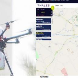 |
by Press on (#35W1V)
The Federal Aviation Administration has selected a small group of companies, including Thales, to support their effort to simplify the process for small UAS operators to comply with current US regulations and safely integrate their operations into the US National Airspace System (NAS). Key Points FAA selected a small group of supplies to support […]
|
 |
by Joshua Ziering on (#35VV5)
Integrity. It’s central to everything we do at Kittyhawk. Whether it’s our professional standards, our data, or our marketing, we infuse everything we do with integrity. It’s in our DNA, and it’s a core value that’s going to help drive the drone industry forward. That’s why it’s so disappointing when a publicly traded company that […]
|
 |
by Press on (#35VCX)
In January 2018, ENAC (Ecole Nationale de l’Aviation Civile, the French Aviation University) will open the first European diploma dedicated to operation and applications of drones, the “Unmanned Aircraft Systems Services and Managementâ€. Advanced Masters Registration is open on www.enac.fr Shape the future of the drone industry Drones, aka UAS, UAV and RPAS, are revolutionising […]
|
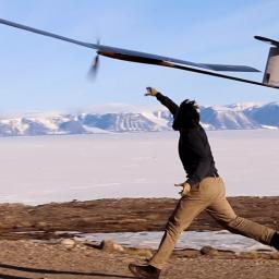 |
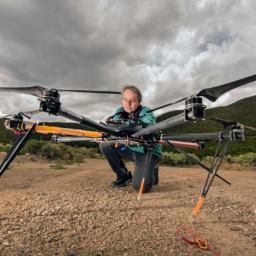
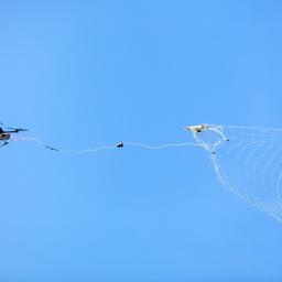
by Press on (#35TMG)
By: Guillaume Jouvet, ETH Zürich Solar-powered flying platforms have yet to prove their real-world applicability outside of targeted demonstrations. Monitoring glaciers in polar regions is in pole position to become a primary application, as the midnight sun offers ideal conditions for perpetual flights. What better place than the Arctic for testing the new generation of solar-powered […]
|
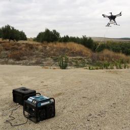 |
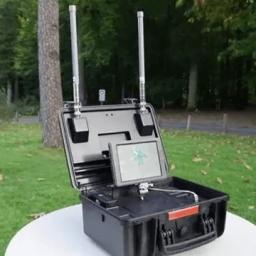
by Press on (#35TJN)
In the frame of emergency situations, natural disasters, remote locations, or wide events, the lack or the total absence of cellular coverage is a recurring challenge and can even become a matter of saving lives. Better coverage takes sometimes weeks to be settled and requires heavy and expensive operations. Thanks to its tethered UAV systems […]
|
 |
by Press on (#35TGK)
A 44-year-old man has been charged with attempting to convey a Class A article into prison, attempting to convey a Class B article into prison and possession with intent to supply. Steven Kelly, of Thornwood Close, Anfield, was remanded in custody to appear before Liverpool magistrates court today, Friday 20th October. Merseyside Police have arrested a […]
|
 |
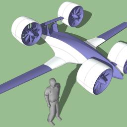
by Gary Mortimer on (#35TBN)
Not only a UTM but an aircraft as well coming out of the dark this week in Dubai. Announcements will be made about partnerships and the airspace management system. The AAV (Autonomous Aerial Vehicles) is a tilt-rotor that can lift up to 150kg (330lbs). If there are truely any serious contenders in this space I […]
|
 |
by Press on (#35RTT)
The team at Drofika is pleased to announce that they have partnered with PlanGrid, the leader in construction productivity software. Available today, Drofika users can upload imagery and analysis from the Drofika platform to PlanGrid for easy access and use in the field. Drofika’s smart aerial data platform allows users from industries such as construction, […]
|
 |
by Press on (#35R0N)
Controlled drone interception Today it is easy and cheap to buy a drone. Drones have created new ways for smugglers and can be easily used to disturb public order and security. With DroneCatcher this can now be countered in a fully controlled manner. The DroneCatcher system is one of the very few counter-drone systems, which […]
|
 |
by Press on (#35JCV)
Non-destructive inspection of engineering equipment, products and installations has always received support from inventors through offering remote vision gadgets / instruments that help in close and detailed examination of the object under inspection. Almost 100 years back, first industrial borescope was invented (in 1921) which allowed inspectors to examine places that were otherwise inaccessible or […]
|
 |
by Press on (#35JCX)
UAV mapping projects require reliable, repeatable accuracy before they can be used and trusted by professional clients. The most common method of achieving this has been placing ground control points (GCPs) which must be spread across the entire site. Whether traditional surveyed targets or the various smart GCPs with built-in GPS, GCPs require site access […]
|
 |
by Press on (#35JAV)
The unprecedented waiver granted by the Federal Aviation Administration (FAA) to allow CNN to fly a small unmanned aircraft system (UAS) over crowds represents an important milestone for the future use of commercial drones. The waiver applies to the provision of the federal regulations for commercial operations of small UAS, known as Part 107, that […]
|
 |
by Press on (#35G2D)
Vancouver, BC / TheNewswire / October 18, 2017 – Global UAV Technologies Ltd. (cse:UAV) YRLLF, +2.67% (YAB2) (the “Company†or “Global UAVâ€) announces that its wholly owned subsidiary Pioneer Aerial Surveys Ltd. has been contracted to perform additional UAV-MAGTM survey work for SSR Mining Inc. (formerly Silver Standard Resources Inc.) (“SSRMâ€). On July 25, 2017, Global UAV announced […]
|
 |
by Gary Mortimer on (#35FWZ)
Phase One Industrial and Lufthansa Aerial Services announced that they have signed an agreement to explore collaborative development and deployment of unmanned aerial vehicles (UAVs) for a range of specialized industrial surveying and inspection projects. Under terms of the agreement, Phase One Industrial and Lufthansa Aerial Services are testing and evaluating scenarios for UAV-based aerial equipment featuring Phase […]
|
 |
by Press on (#35FMN)
Trimble Dealer Seiler Instrument & Mfg. Co., Inc., offers advanced, integrated tools for geospatial professionals in the Midwest U.S. With more than 72 years of successful sales and service, Seiler Instrument has built its reputation on exceptional customer support, while concentrating its product offering on solutions from like-minded suppliers. “We are thrilled to welcome Seiler Instrument […]
|
 |
by Press on (#35FMQ)
DR1 Racing, the premiere international drone racing organization, today announced the company’s flagship drone racing series, the DHL Champions Series Fueled by Mountain Dew, will debut on beIN SPORTS October 19th, with the series Finals airing on CBS Sports on November 4th at 1:30pm EDT. This will be the first ever drone racing program to appear […]
|
 |
by Press on (#35FMS)
We are looking for talented and curious Machine Learning Experts to join our growing team in Berlin. You will be part of a skilled Machine Learning team at Pix4D and your task will be to design, evaluate and implement image segmentation and object detection pipelines based on Machine Learning techniques that will be integrated in […]
|
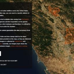 |
by Press on (#35FH8)
Mapbox has published a new map to give people affected by the wildfires in Northern California and across the U.S. access to the most up to date information on fire perimeters in relation to specific locations and addresses. Using the best available data coming from Geospatial Multi-Agency Coordination and from the agencies and first responders on the ground, […]
|
 |
by Press on (#35FAP)
Robb the Robot Guy, a research and advisory firm supporting all participants in the robotics industry, has compiled an in depth report on the field of First Person View (FPV) drone racing. Over the last 2 years, Robb has studied the field of FPV drone racing and identified the market scope, trends, drivers, challenges, opportunities, […]
|
 |
by Press on (#35C9X)
Aviation Investigation A17Q0162 On 12 October 2017, a Beech King Air A100 operated by Skyjet M. G. was on an instrument flight rules flight from the Rouyn-Noranda (Quebec) airport (CYUY) to the Jean Lesage International Airport (CYQB) in Québec City, Quebec with 2 crew members and 6 passengers on board. The aircraft was approaching runway […]
|
 |
by Press on (#35D7Q)
Boulder, CO – (October 18, 2017) – TerraLogic Sustainable Solutions, an environmental consulting firm specializing in infrastructure and transportation, and Wohnrade Civil Engineers, Inc., a full-service engineering firm leading the way in both the development of precision aerial mapping, and incorporating Unmanned Aerial System data into civil engineering design, announced today that they have been […]
|
 |
by Press on (#35C2K)
In a welcome move for professional drone users, VTOL drone company Wingtra announced its official partnership with Pix4D. With WingtraOne, Wingtra’s main product, fast emerging as an industry favorite for aerial data collection, this partnership with Pix4D aims to augment its status with a full end-to-end solution including 2D map and 3D model construction from […]
|
 |
by Press on (#35BT1)
In August 2017, northern Nevada-based Strix Imaging used drone technology to map an 18,000-acre mine exploration site, south of Elko, for Contact Gold LLC — about 28 square miles — in the largest commercial drone mapping project ever completed in the United States. Strix provided Contact Gold with topographic products at 6-inch accuracy over the […]
|
 |
by Press on (#35BT3)
General Atomics Aeronautical Systems, Inc. (GA‑ASI) has signed a Memorandum of Understanding (MOU) with Huneed Technologies Co. Ltd. (Huneed) establishing potential areas of future collaboration. GA-ASI is the leading manufacturer of Remotely Piloted Aircraft (RPA) systems. Huneed is a Korean developer and manufacturer of airborne systems, defense communication systems, and commercial IT systems. GA-ASI and Huneed […]
|
 |
by Press on (#35BR5)
Two competing teams from the United States and Japan will fly their drones across the Pacific Ocean to test the endurance and capability of their vehicles to fly long distances – unmanned. The event, dubbed the “Pacific Drone Challenge†will pit the technology of an American team – Sabrewing Aircraft Company in the Silicon Valley […]
|
 |
Skyward Approved to Give Commercial Drone Operators Instant Access to Controlled Airspace with LAANC
by Press on (#35B62)
Skyward, a Verizon company has been approved to give commercial drone operators instant access to controlled airspace with the Low Altitude Authorization and Notification Capability (LAANC) services from the Federal Aviation Administration (FAA). The program will roll out this fall at Cincinnati International Airport (CVG), Reno (RNO), San Jose (SJC), and Lincoln (LNK) among others. LAANC will enable businesses to access […]
|
 |
by Rob Thompson on (#35AH5)
The CUAS Coalition is announcing our Coalition Directors & Research Team who have signed on to solve a very complex problem that affects the future of many people in the United States and abroad. Globally, this is becoming an increasing problem with the advent of cheap equipment and easy to control platforms, drones are allowing […]
|
 |
by Gary Mortimer on (#35A7E)
Dane Wicks (27) had a flyaway in Guernsey that left him out of pocket and without a drone. Guernsey is an island in the English Channel off the coast of Normandy, France. Mr Wicks pleaded guilty yesterday to using a surveillance drone within 150 metres of a congested area on 21st May 2017. That congested area was […]
|
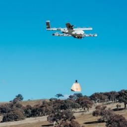 |
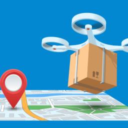
by Press on (#358CB)
Project Wing (X’s drone delivery project), are testing their drone delivery technology with households in south-eastern Australia. For the first time anywhere, they have made drone deliveries directly to the yards of testers (deliveries for their last pilot took place in an open field at Virginia Tech). And starting this week, testers will be able […]
|
 |
by Press on (#359K0)
DJI, the world leader in civilian drones and aerial imaging technology, will open its first Japan DJI Arena in Tokyo, “DJI Arena By JDRONE Tokyo,†on Saturday, October 21. The 5,759-square-foot arena will not only consist of a flying area, but also feature a retail store and offer technical support. The Tokyo DJI Arena will […]
|