2015 may be remembered as the most severe El Nino ever
 Scientists' understanding of the El Nino phenomenon - in which a reversal of warm and cool currents in the Pacific Ocean brings wet weather to America's West Coast and elsewhere while areas used to monsoon rainfall remain dry - is better than ever. But that hasn't helped our ability to accurately predict El Nino years, and of course even prediction does nothing for mitigating the sometimes disastrous effects.
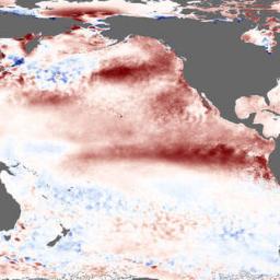
El Nino-watchers at America's National Oceanic and Atmospheric Administration (NOAA) noted worrisome ENSO-related changes in both sea temperature and air pressure earlier this year. They declared the return of the Boy in March. Australia's Bureau of Meteorology decided to wait until May. Such forecasts can be wrong. Despite signs of the phenomenon last year, no monstrous event actually emerged. But during July the surface temperature of the central equatorial Pacific was almost 1C higher than expected, and its equivalent in the eastern Pacific was more than 2C above expectations. Among other things, that puts the temperatures in these areas well above the 26.5C minimum needed for the formation of tropical storms. Right on cue, on July 12th, six such cyclones spun in the Pacific-more than on any previous day in over four decades.Mike Halpert, the deputy director of NOAA's Climate Prediction Centre, believes the current Nino could be among the strongest since records began in 1950. That one was responsible for 21,000 deaths and $36B in damages on houses, bridges, and culverts.
Time to get out the raincoats and umbrellas?