 |
by Press on (#4560R)
Up and coming drone racing brand, Archangel FPV LLC, recently announced the release of their racing drone lineup. The new limited edition drones were conceived to commemorate the 2018 DHL Champions Series fueled by Mountain Dew and was presented by DR1 Racing. The Archangel drone was first unveiled during the airing of Season 2 of […]
|
sUAS News
| Link | https://www.suasnews.com/ |
| Feed | http://www.suasnews.com/feed |
| Updated | 2026-07-22 05:30 |
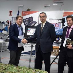 |
by Press on (#455QY)
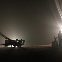
The Spanish Armed Forces, through the DGAM (Dirección General de Armamento y Materiales), has acquired two Alpha 800 UAV helicopters from Alpha Unmanned Systems, SL (AUS). The Alpha 800 is a tactical 14 kg gasoline powered helicopter that provides 3 hours of continuous flight with a 3 kg payload and 30 km of operating range. It […]
|
 |
by Press on (#455R0)
DJI, the world’s leader in creative camera technology, today launched the new DJI Pro website https://pro.dji.com. Since the introduction of the Z15 three-axis aerial gimbal in 2014, DJI has been committed to providing reliable and easy-to-use tools for creative visionaries. The DJI Pro website continues that commitment, providing a comprehensive user experience for cinematographers and filmmakers […]
|
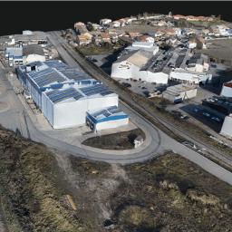 |
by Press on (#4557P)
Inpho version 9 combines the classical photogrammetric capabilities with modern 3D workflows, all in a single software environment. The new MATCH-3DX module incorporates state-of-the-art Semi Global Matching (SGM) techniques that enable photogrammetrists to reach a new level of quality and precision when generating large scale point clouds and true orthophotos from aerial (frame) images. With […]
|
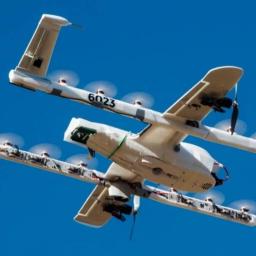 |
by Press on (#453CH)
Wing is reshaping the future of delivery. We are an on-demand drone delivery service that can deliver food, medicine or other items within minutes. We’ve also developed an unmanned traffic management platform–a kind of air traffic control for unmanned aircraft–to safely route drones through the sky. Our service is faster, safer and produces far less […]
|
 |
by Press on (#451YX)
MUNCIE, Ind. – The Academy of Model Aeronautics (AMA) yesterday named Chad Budreau as its new Executive Director. Budreau has held this position on an interim basis since April 2018, and previously served as AMA’s Public Relations and Government Affairs Director. “With Chad’s extensive experience in model aviation and deep understanding of AMA’s mission, he […]
|
 |
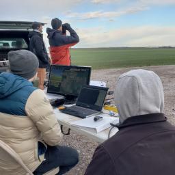
by Patrick Egan on (#450RB)
Anecdotes from the Drone Symposium/Pancake Breakfast. Lead-time on the pop-up symposium was short, but it was great to be in LA around Christmas, and if you haven’t been for the holidays you should try it. Seventy plus degrees, palm trees, and decorations make for a surreal vibe to be sure. Besides the environs, we have […]
|
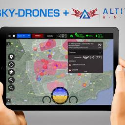 |
by Press on (#450KP)
Sky-Drones – the leading UAV flight control system solutions expert partnered with Altitude Angel – aviation technology company who creates global-scale solutions that enable safe integration and use of fully autonomous drones into global airspace. Sky-Drones creates professional UAV flight control systems including autopilot hardware, onboard software, ground control software and cloud services. The company […]
|
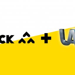 |
by Press on (#4506M)
Flock are thrilled to announce that they have partnered with UAV8, a renowned commercial drone training school. The collaborative partnership has enabled UAV8 to provide free Flight Assessment insurance with their courses, protecting training pilots with both hull (drone and airborne accessories) and Public Liability cover. This allows pilots to take their assessment with peace […]
|
 |
by Press on (#44ZQW)
The GAUSS project, a GSA initiative coordinated by everis Aerospace, Defense, and Security (everis ADS), recently organised a workshop at the University of Cranfield (United Kingdom) to analyse the benefits of Galileo and EGNOS in the context of operations involving unmanned systems (UAS) and their air traffic management (in Europe, U-Space). The event gathered relevant […]
|
 |
by Gary Mortimer on (#44ZNB)
On Tuesday the Ghanian government approved a $12.5 million deal with Zipline to roll out their medical delivery service in the country. The company will build four nodes all staffed by Ghanaians. The first will be at Suhum in Eastern Ghana. Operating 24/7 the nodes will cost the Government $88,000 a month and the current contract […]
|
 |
by Press on (#44XHM)
Want to win up to 50.000 euro prize money? Sign your team up for the next edition of DroneClash. (Early bird action till 14-12-2018) This next-level FPV competition – a kind of 3D Robot Wars, will be held on March 16, 2019, at the former airbase, Valkenburg in Katwijk, the Netherlands. With six teams already […]
|
 |
by Gary Mortimer on (#44X03)
uAvionix, designer and manufacturer of communications, navigation, and surveillance (CNS) equipment for unmanned and manned aircraft, today announced its plans to establish an office location in the Washington, DC metropolitan area. This expansion reflects the company’s long-term business strategy and the strong growth the company has seen in both the unmanned and manned aviation markets. […]
|
 |
by Patrick Egan on (#44VXB)
I believe it is an insult to those of us who have spent years of our time and countless thousands of dollars trying to safely integrate UAS into the NAS. During my tenure, I have seen colossal waste; dysfunction and jockeying for consulting gigs take precedence over the domestic industry. That goes for FAA, NASA, […]
|
 |
by Press on (#44VXD)
Geneva, 12 December 2018. Skyguide has noted the judgment of the Zurich High Court against an air traffic controller with incomprehension and disappointment. This conviction creates a precedent for Switzerland and for Europe, which jeopardises the safety culture that is deeply embedded within Switzerland’s air navigation services. Safety culture at risk If it is to […]
|
 |
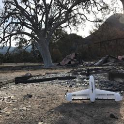
by Press on (#44VXF)
Insitu, a wholly-owned subsidiary of The Boeing Company, assisted from the air in the firefight against the Camp Fire in Northern California, now deemed the deadliest, most destructive wildfire in California’s history. “Our hearts go out to all of those affected by the terrible Camp Fire tragedy,†said Esina Alic, Insitu President and CEO. “We […]
|
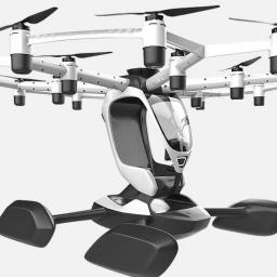 |
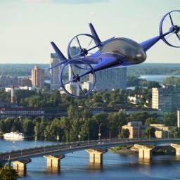
by Press on (#44V98)
Matt Chasen, founder of uShip, is unveiling a new venture today called LIFT Aircraft™ (www.liftaircraft.com) LIFT has developed an electric, vertical takeoff and landing (eVTOL) aircraft and plans to open up LIFT locations where anyone will be able to rent aircraft and experience an entirely new kind of flying – pilot’s license not required. “Flying is probably […]
|
 |
by Press on (#44QZQ)
DroneShield Ltd (ASX:DRO) (“DroneShield†or the “Companyâ€), a worldwide leader in counterdrone solutions, is pleased to announce that it has entered into a Teaming Agreement (the “Agreementâ€) with Thales Programas De Electronica Y Comunicaciones S.A.U. (“Thalesâ€) (a Spanish subsidiary of Thales S.A.), whereby Thales will utilise and promote DroneShield’s products in its defence and security […]
|
 |
by Press on (#44Q1T)
Industry experts plan the future of unmanned aerial spraying Homeland Surveillance & Electronics, LLC (HSE-UAV) a veteran-owned, full-service UAV company, together with U.S. Department of Agriculture (USDA, ARS) and other subject-matter experts met for a 3-day Aerial Spray Conference focused on the expansion and integration of unmanned spraying systems. The workshop was created and hosted […]
|
 |
by Press on (#44PXT)
Due to the growing number of inquiries concerning complete drive units for Unmanned Aerial Systems (UAS), the German manufacturer of 2-stroke and Wankel engines, Sky Power GmbH, has intensified its cooperation with Mejzlik Propeller from the Czech Republic. The objective is the development of propellers coordinated individually to the engine and the customer application. “In […]
|
 |
by Press on (#44PF6)
Altitude Angel, the global company leading Unmanned Traffic Management (UTM), has been named as a key delivery partner in the Transport Systems Catapult (TSC) led UK UTM project. The news follows the aviation technology company’s recent success in delivering ‘Operation Zenith’: the world’s first comprehensive demonstration of how drones can be flown alongside aircraft in […]
|
 |
by Press on (#44PF8)
SALINA — Students studying unmanned aircraft systems at the Kansas State University Polytechnic Campus are receiving a rare flight experience in some of their courses that is positioning them at the forefront of the drone industry. Kansas State Polytechnic’s UAS flight and operations degree option is the first in the nation to introduce flying beyond visual line of sight into […]
|
 |
by Press on (#44PFA)
Droneshield has today released an ASX announcement with regards to its evaluation by the United States Department of Defense. The announcement is as follows: DroneShield Ltd (ASX:DRO or DRO.AU) (“DroneShield†or the “Companyâ€) is pleased to advise the market that the U.S. Department of Defense Asymmetric Warfare Group at Fort A.P. Hill, Virginia has evaluated […]
|
 |
by Press on (#44HDD)
With the drone industry expanding at an exponential rate, it’s unsurprising to see a range of industries and sectors start to unlock the potential that UAVs (unmanned aerial vehicles) offer. One particular industry that has embraced the drone revolution is utilities. Water company Severn Trent’s fleet of drones is generating huge savings in time and through improved efficiencies. Since Severn Trent made the strategic decision to […]
|
 |
by Press on (#44GGS)
Leading automated drone startup Airobotics announced today that it is the first company in the United States to receive a Certificate of Waiver (CoW) from the Federal Aviation Administration (FAA) that combines three elements: flying Beyond Visual Line of Sight (BVLOS) for automated drone operations, over human beings, with a visual observer that is not required to […]
|
 |
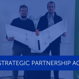
by Press on (#44G9Y)
The fixed-wing drone leader heads into 2019 with a more independent approach—its two co-leaders looking to build on the eBee X drone’s success by leveraging a wider array of strategic partnerships Cheseaux-sur-Lausanne, Switzerland, December 6, 2018—senseFly, the industry’s leading provider of professional fixed-wing drone solutions and a subsidiary of Parrot Group, today announces the evolution […]
|
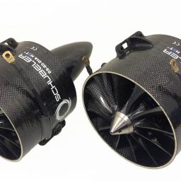 |
by Press on (#44GA0)
Siegen, Germany- As part of ongoing global expansion, Microdrones is proud to announce a merger with Schübeler Technologies. Since its founding in 1997, Schübeler has built a global business by providing advanced fan propulsion jets and lightweight composite materials fabrication. Offering a full product lineup of robust turbofans, jets, compressors, pumps, electric motors, carbon fibre […]
|
 |
by Press on (#44GA2)
Indian Institute of Drones has trained Multirotor drone pilots to all FTOs in India organized by DGCA. Training was conducted for 5 days, which covers all the topics as mentioned in DGCA regulations book. This training includes theory classes, How to make a drone? And How to fly a drone? During training, our trainers followed […]
|
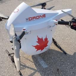 |
by Press on (#44DYC)
Drone Delivery Canada ‘DDC or the Company’ (TSX.V:FLTOTC: TAKOF), is pleased to announce that it has executed a commercial agreement with the Moose Cree First Nation to deploy DDC’s drone delivery technology platform with the Moose Cree First Nation communities. The Company is currently permitted to commercially operate its drone delivery platform within the Moosonee and Moose Factory communities with its […]
|
 |
by Press on (#44DYD)
County Durham has joined a network of innovative cities and regions across Europe in an initiative to nurture the development of airborne smart mobility, which includes services such as air taxis and ambulances delivering medical equipment. The Urban Air Mobility (UAM) Initiative is part of the European Innovation Partnership on Smart Cities and Communities (EIP-SCC), […]
|
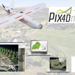 |
by Press on (#44CB0)
Aeromao celebrates its 4th year as an official partner of Pix4D offering the Pix4DMapper Aeromao edition and Pix4D related products. The Pix4DMapper Aeromao Edition is a fully featured image processing software package bundled with an Aeromapper UAV system, that includes two perpetual licenses of the worldwide leader in photogrammetry software. This bundle offers the additional […]
|
 |
by Press on (#44CB2)
TAKE $600 OR MORE OFF INDUSTRY LEADING SENSORS WHEN ORDERED IN 2018 In preparation for the 2019 growing season, Sentera is announcing a limited time price promotion for its most popular NDVI, NDRE (Red Edge), and multispectral crop scouting solutions. Through December 2018, you can save $600 or more off MSRP. This limited-time promotional pricing […]
|
 |
by Press on (#44CB4)
SCOTTSDALE, AZ, December 5th, 2018 – Desert Rotor has officially opened a new global headquarters in Scottsdale, Arizona. Located at the heart of the commercial district in the Scottsdale Airpark. Desert Rotor designs and manufactures commercial unmanned ground control stations compatible with most leading UAV designs, autopilots and hardware. Desert Rotor ground control stations are […]
|
 |
by Press on (#44BMB)
Geneva, 5 December 2018. Research specialists from the Aviation Research Center Switzerland (ARCS) commissioned by skyguide have demonstrated, together with telecom provider Swisscom, that Switzerland’s existing mobile telephony infrastructure is suitable for ensuring the safe performance of drone flight operations in Swiss airspace. A series of measuring flights showed that the exchange of data between […]
|
 |
by Press on (#44B41)
Zain Group (“Zainâ€), a leading Middle Eastern mobile and data services operator headquartered in Kuwait has entered into a Teaming Agreement with DroneShield Ltd (ASX:DRO) (“DroneShieldâ€), a worldwide leader in counter-drone solutions, which will see the companies working together on meeting Zain’s customers’ requirements for counter-drone security solutions in the region. In October 2018, Zain Group announced the […]
|
 |
by Press on (#449S5)
AeroVironment, Inc. (NASDAQ: AVAV), a global leader in unmanned aircraft systems for both defense and commercial applications, today announced it is supporting the National Park Service Inventory and Monitoring Program to assess the environmental impact of the Woolsey wildfire in the Santa Monica Mountains National Recreation Area of Southern California. Burning over 96,949 acres, the devastating […]
|
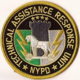 |
by Press on (#449S7)
Marking a truly historic moment in the sUAS history, NYPD has officially and publicly announced their addition of “crime-fighting drones†to their ranks. Led by their Technical Assistance Response Unit (TARU), NYPD has added 14 drones to their arsenal to assist with their operations. FLYMOTION is pleased to have provided the consultation, equipment, training, and […]
|
 |
by Press on (#448Z7)
Award-winning company Heliguy has entered into a strategic partnering agreement with Survey Solutions Scotland – the sole UK distributor for Delair UAV fixed-wing products – to offer clients the long-range, BVLOS-ready Delair UX11. This state-of-the-art UAV is a professional aircraft suitable for large-area mapping, with BVLOS (beyond visual line of sight)-ready capabilities and optional PPK (post-processed kinematic) for survey-grade results. Ruairi Hardman, […]
|
 |
by Press on (#448MN)
ANCHORAGE, Alaska — Alaska Aerial Media (AAM) in collaboration with Advanced Aerial Education (AAE) is the first small unmanned aircraft service company in Alaska to obtain a certificate of waiver (COW) from the Federal Aviation Administration (FAA) for operations over people in the State of Alaska. The provisions of the waiver incorporate the scenario-based end […]
|
 |
by Press on (#448MQ)
NASA has partnered with the Japan Aerospace Exploration Agency, or JAXA, to successfully demonstrate the safe integration of unmanned aircraft systems (known as UAS, or drones) on a use case to support emergency response and disaster recovery activities. This test, which happened in October 2018, connected JAXA’s Disaster Relief Aircraft Information Sharing Network, or D-NET, […]
|
 |
by Press on (#448J2)
SPH Engineering is announcing the latest update of its Drone Show Software — the world’s only widely available software for drone show management and control. Rotating dance moves, smoother movement and a virtual fence — the new Drone Show Software update focuses on making choreography even more precise, on viewer security, and on making drone shows easily […]
|
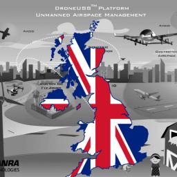 |
by Press on (#448FY)
This program is under the governance of the Transport Systems Catapult (TSC) which is working with ANRA Technologies as a UTM service provider (UTMSP) along with support from the appropriate UK Government regulators as well as an Air Navigation Service Provider (ANSP) and other stakeholders. Currently, numerous UTM services are developing independently of any framework – potentially resulting in […]
|
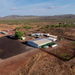 |
by Press on (#448G0)
Airbus Defence and Space announced the opening of the world’s first High Altitude Pseudo-Satellite (HAPS) flight base serving as the launch site for the Zephyr UAV in Wyndham, Western Australia. This site has been chosen due to its largely unrestricted airspace and reliable weather and is the result of significant investment by Airbus into its […]
|
 |
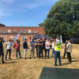
by Patrick Egan on (#447FK)
Here is your chance to sit down and break pancakes with some of the people you have read stories about in the sUAS News over the last year. You never know: you may be sitting next to a few existentialists eating pigs in a blanket. But there won’t be any drone nihilists at this breakfast […]
|
 |
by Press on (#447FN)
Nevis Environmental provides survey services and specialist management of environmental issues across a project lifecycle from its offices in the Highlands and North of England. They were delighted to sign a memorandum of understanding with ROAVR – an aerial data provider to form a partnership to market the use of drones in environmental and ecological surveys […]
|
 |
by Press on (#447FQ)
Measure, a leading international provider of aerial intelligence, has completed a drone flight in the DC Metropolitan Flight Restricted Zone (FRZ) as a result of a waiver granted by the Federal Aviation Administration’s Systems Operations Security unit. Washington DC’s FRZ was put in place in 2007 and prohibits aviation operations outside of the Department of […]
|
 |
by Press on (#446JE)
Vodafone is conducting 4G drone test trials at the BCN Drone Center to enable the massive use of drones in the near future. Soon, all drones equipped with a 5G SIM card will be able to be controlled and geo-localized simultaneously. This will also enable the possibility of landing them in case of accessing restricted areas […]
|
 |
by Press on (#445EY)
Dronefly.com is an innovative and exciting place to work for tech geeks and drone nerds. We love learning about new technologies and helping our customers find the perfect solution to fit their needs. Over the past four years, we have been recognized as a top DJI and FLIR Dealer and are still growing very rapidly! […]
|
 |
by Press on (#445F0)
UAVOS Inc. has successfully tested the new GLIDER flight algorithm for the VTOL UAV, featuring a high level of safety in case of failures of the UAV power plant in flight. Flight mode GLIDER not only allows the helicopter to automatically switch into autorotation mode when the engine fails, it also protects the power unit […]
|
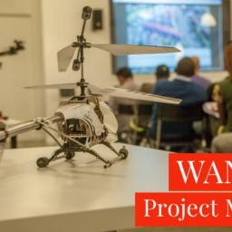 |
by Gary Mortimer on (#444NH)
africanDRONE (aD) is seeking a part-time (4 half-days per week) Project Manager in Nairobi, Kenya to assist the ExCo Fellow with project related tasks, but also independently grow the organisation. The Project Manager will be working directing with the ExCo Fellow but will be reporting into the COO in Cape Town. aD is incubated and supported by Code for Africa, […]
|