 |
by Press on (#40WJ8)
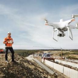
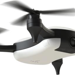
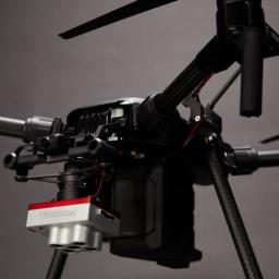
DJI, the world’s leader in civilian drones and aerial imaging technology, today announced the global rollout of the Phantom 4 RTK, a high-precision aerial survey drone that combines centimeter-level navigation and positioning with a high-performance imaging system to improve survey efficiency and accuracy, reducing operational difficulty and cost. “The Phantom 4 RTK was engineered to […]
|
sUAS News
| Link | https://www.suasnews.com/ |
| Feed | http://www.suasnews.com/feed |
| Updated | 2026-07-22 03:45 |
 |
by Press on (#40VJW)
DroneShield has today officially released DroneShield CompleteTM v2.0, the single largest software update for the DroneSentry & DroneSentinel product suites. DroneShield CompleteTM offers users a ‘best in class’ drone detection and mitigation interface with enhancements to tracking, navigation, functionality and usability. DroneShield CompleteTM includes a graphic user interface (GUI) that compiles and analyses vast amounts of environmental data to display to user seamlessly […]
|
 |
by Press on (#40V99)
Orbital Corporation Ltd (‘Orbital UAV’, ‘the Company’) is pleased to announce the expansion of its Long Term Agreement (‘LTA’, the ‘Agreement’) with Insitu Inc. (Insitu), a wholly owned subsidiary of The Boeing Company. The Agreement builds on Orbital UAV’s existing partnership with Insitu and increases the scope, scale and term of work outlined in the […]
|
 |
by Press on (#40PGK)
UAVOS Inc. has successfully completed the first stage of the flight tests of the 10-meter prototype of the High Altitude Pseudo Satellite (HAPS) ApusDuo, which was manufactured as part of the development program of ApusDuo solar aircraft with a wing span of 28m. That prototype was made for testing control algorithms, including take-off and landing, […]
|
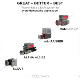 |
by Press on (#40PGN)
The commercial UAV LiDAR pioneer pushes industry boundaries with three new product announcements at INTERGEO 2018 Los Angeles, CA — October 12, 2018 — Phoenix LiDAR Systems, LLC., the industry leader in commercial UAV LiDAR systems, is proud to announce its three newest LiDAR solutions that will challenge LiDAR conventions once again at INTERGEO 2018, […]
|
 |
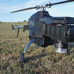
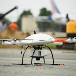
by Press on (#40PCA)
The KittyHawk performs rigorous applications that exceed the abilities of most UAVs on the market. Like all Mobile Recon units, the KittyHawk is engineered to efficiently and effectively support a myriad of missions: Carry temperature-sensitive supplies of up to 25 pounds in a transport box. Monitor, count and track wildlife or other heat sources with thermal […]
|
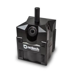 |
by Press on (#40NT7)
GeoSLAM and Orbit GT to demonstrate innovations using iSTAR Pulsar data; NCTech to showcase new AI capabilities for identifying objects in 360 images NCTech, a developer of reality imaging systems, will next week showcase its iSTAR Pulsar mobile 360-degree data capture system at the INTERGEO conference and tradeshow. Companies at INTERGEO, including GeoSLAM and Orbit […]
|
 |
by Press on (#40KJB)
Terra Drone, a leading global commercial drone technology company , acquires a significant stake in Swedish aerial robotics for underground mining startup, Inkonova AB Terra Drone’s UAV inspection, survey, and other service provisions cover various industries globally including mining; Inkonova’s main market. The deal is comprised of a cash injection, changes to the management team, […]
|
 |
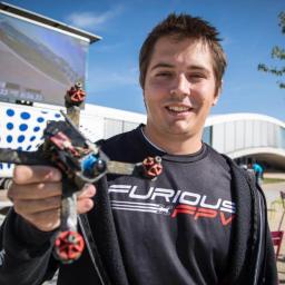
by Gary Mortimer on (#40JAP)
It’s arrived, remember the feel-good story about the designer 20-year-old Utah-based, George Matus? The main event, the Teal One launches today. According to Teal, “Teal One is more than a flying camera. It’s the only consumer drone that everyone – from first-time flyers to advanced pilots – will love to fly.†Developers will be interested in […]
|
 |
by Press on (#40HJR)
The Ardupilot Suzhou conference is getting closer, and speakers have been confirmed. We look forward to all our speakers: Non-GPS navigation with Randy Mackay ArduSub with Craig Elder Swarm in Mission Planner with Michael Oborne Choosing the correct hardware setup with Philip Rowse Better Plane Tuning with Tom Pittenger Lua Scripting with Michael du Breuil […]
|
 |
by Press on (#40HJT)
Vancouver, British Columbia, Oct 09, 2018 (Newsfile Corp via COMTEX) — Global UAV Technologies Ltd. (cse:UAV) YRLLF, +23.97% (YAB2) (the “Company†or “Global UAVâ€), a diversified, vertically integrated drone technology company, is pleased to announce that Global UAV and Planck Aerosystems Inc. (“Planckâ€) have successfully performed a fully autonomous landing and takeoff from a moving […]
|
 |
by Press on (#40HAV)
Arlington, VA — XRY Drone lets investigators extract and analyze data from popular drone models being used for illegal activity — to reveal flight paths, origin, behavior and other critical information that can identify operators Police, corrections agencies, border control and military organizations around the globe are developing methods to counter the growing threat from […]
|
 |
by Press on (#40FAH)
Plowman Craven is proud to have collaborated with BAM Nuttall and Network Rail on an innovative virtual reality project that showcases to rail users the extensive works taking place to upgrade the Aberdeen to Inverness line in Scotland. Using our industry-leading Vogel R3D drone survey system, fitted with a 4k, high-resolution 360-degree camera, our team overflew […]
|
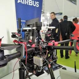 |
by Press on (#40EVK)
Mobilicom Ltd., a global mission-critical-communications solution provider, announces that world-leading aerospace pioneer Airbus has integrated Mobilicom’s SkyHopper PRO solution into its Innovation drone platform. The platform is used to broaden Airbus’ vision and demonstrate its mission operation solutions in the commercial and homeland security drone space. Mobilicom’s SkyHopper is a holistic solution for commercial and […]
|
 |
by Patrick Egan on (#40DAF)
Every wonder why the Drone industry just can’t get no satisfaction? Straight off of the FAA Drone Registration Task Force roster of shame Nancy Egan – The saga of 3DRobotics is sad indeed. But the lack of understanding and leadership were astounding. She was happy with the notion of the FAA paying/doing the research for […]
|
 |
by Press on (#40CVW)
Flyability joins the DARPA SubT Challenge granted team, CERBERUS, led by University of Nevada, Reno, along with international partners including ETH Zurich, University of California, Berkeley, and Sierra Nevada Corporation. Project CERBERUS will bring groundbreaking robotic solutions into the field of subterranean deployments. With the goal of supporting public safety professionals in time-sensitive operations or disaster […]
|
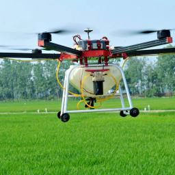 |
by Press on (#40CJD)
North Dakota State University’s (NDSU) Agricultural and Biosystems Engineering department has purchased an herbicide-spraying unmanned aerial vehicle that can carry over four gallons of liquid and autonomously disperse it for 30 minutes at a time, covering around 33 acres of crops in one hour. According to the Brainerd Dispatch, NDSU engineers unveiled the six-foot-wide AG V6+ […]
|
 |
by Press on (#40CJF)
Frontex, the European Border and Coast Guard Agency, has begun testing the use of Remotely Piloted Aircraft Systems (RPAS) in Greece, Italy and Portugal to monitor the European Union’s external borders. Frontex is exploring the surveillance capability of the medium altitude long endurance RPAS and evaluating the related cost efficiency and endurance. The agency will […]
|
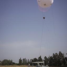 |
by Press on (#40CEE)
As a cost-effective surveillance solution, the SkyStar aerostat systems are ideal for securing the Tokyo 2020 Olympic games The Israeli-based aerostat company RT LTA Systems Ltd. will present the SkyStar family of aerostats at SEECAT, the Special Equipment Exhibition & Conference for Anti-Terrorism in Tokyo, Japan. RT’s SkyStar aerostats are ideal for securing massive public […]
|
 |
by Press on (#40CEG)
AeroVironment, Inc. (NASDAQ: AVAV), a leader in unmanned aircraft systems (UAS) and tactical missile systems (TMS), today announced a new strategic relationship with General Dynamics Land Systems (GD), the leader in ground combat vehicles, to produce highly integrated and effective tactical UAS and TMS for armored ground combat vehicles. “By integrating the leading small tactical UAS and […]
|
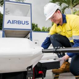 |
by Press on (#40C61)
Scheduled to launch at Singapore’s Marina South Pier in November 2018, Wilhelmsen’s Ships Agency and Airbus will be piloting the delivery of maritime essentials via Airbus’ Skyways unmanned aircraft system (UAS) to vessels at anchorage. Make history with us Be one of the first in the world to have maritime essentials delivered to your vessels. […]
|
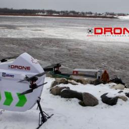 |
by Press on (#40BYT)
Drone Delivery Canada ‘DDC or the Company’ (TSX.V:FLT OTC: TAKOF), is pleased to announce that Moose Cree First Nation’s Mr. Stan Kapashesit – Director of Economic Development has joined DDC’s Advisory Board to assist in the Company’s commercial strategy for remote communities in the James Bayregion. “Moose Cree is a proactive community and feels DDC’s drone delivery solution can lower costs, […]
|
 |
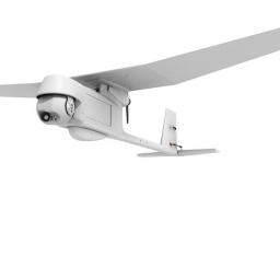
by Press on (#407W9)
The Aeromapper Talon Amphibious allows maritime operations by autonomously belly landing on water. It’s the perfect solution for aerial observation, data collection and mapping thanks to its dual camera set up and video link range up to 20kms. It is the world’s first fixed-wing drone for commercial use that lands on water, parachutes down on […]
|
 |
by Press on (#407WB)
e2E Services Limited (e2E), the provider of communications engineering and technical consultancy services to the satellite communications market, has launched a low-cost, low power, compact and lightweight satellite communication terminal, called e2Eaccess UAS-I, for enhancing communications connectivity of small Unmanned Aircraft Systems (sUAS). e2Eaccess UAS-I is a revolutionary product that will transform the operation of […]
|
 |
by Press on (#4079N)
Hitachi has launched a drone platform solution expanding their existing infrastructure inspection services portfolio with an AI-assisted, drone-based service. Over the last years, the societal impact of drone technology is steadily increasing and it is expected that the use of drone technology will improve business efficiency in many fields. Today, professional drone applications mainly target […]
|
 |
by Press on (#4079Q)
Brett Hansard As part of a new program, Argonne’s researchers are evaluating what it takes to power drones with batteries. Not all batteries are created equal. State-of-the-art battery technology for cell phones, for instance, looks a lot different from batteries for electric cars. Similarly, land-based electric vehicle battery technology differs in key respects from batteries […]
|
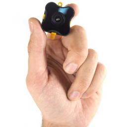 |
by Press on (#406EB)
The multi-pixel Time-of-Flight sensor of TeraRanger Evo product family! Track motion, sense depth, monitor and count: people or items thanks to an output of 64 high-speed distance readings. Developed for indoor applications, Evo 64px provides a matrix of 8×8 pixels over a 15-degree FOV, with a maximum range up to 5m. Choose between 2 operating modes. Go […]
|
 |
by Patrick Egan on (#405FC)
Anyone who is calling themselves the Silicon Valley of Drones outside of Guangdong, China is either delusional, a wishful thinker, a huckster, or has no internet access. You may also be possibly suffering from the same afflictions if you believe or espouse the notion that there is no money in hardware. I am here to […]
|
 |
by Press on (#405FE)
AeroVironment, Inc. (NASDAQ: AVAV) today announced the United States Air Force awarded the company a $13 million indefinite delivery/indefinite quantity (ID/IQ) contract on Sept. 30, 2018 for RQ-11B Raven® small unmanned aircraft systems (UAS) to support Latin American and Caribbean nations. United States Government fiscal 2018 operations and maintenance funds of $2,800,000 were committed at the time of […]
|
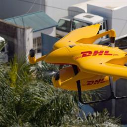 |
by Press on (#40462)
Drone manufacturer Wingcopter, Deutsche Gesellschaft für Internationale Zusammenarbeit (GIZ) GmbH and DHL complete successful pilot project More than 180 take-offs and landings, over 2,200 km flown and roughly 2,000 flight minutes recorded. Darmstadt/Eschborn/Bonn, 4 October 2018: Revolutionising the delivery of medicines to remote areas using drones – the pilot project Deliver Future proves that it’s […]
|
 |
by Press on (#4032R)
Kittyhawk, the market leader in enterprise drone operations software, today announced a strategic investment from The Travelers Companies, Inc. (NYSE: TRV). The investment will help the company bring unified drone operations to new markets. Travelers has been a pioneer in adopting the use of drones within the insurance industry. The company was one of the […]
|
 |
by Press on (#402GN)
Vigilant Aerospace Systems, Inc. has successfully participated in a ground-breaking unmanned aircraft flight that helps to pave the way for routine flights over people, a major milestone in the development of commercial drone regulations and the use of unmanned aircraft in the US. Vigilant Aerospace provided airspace monitoring, flight safety and airspace logging using its FlightHorizon […]
|
 |
by Press on (#4022Z)
Drone Delivery Canada ‘DDC or the Company’ (TSX.V:FLTOTC: TAKOF), is pleased to announce that the Company conducted numerous successful drone delivery test flights in the communities of Moosonee and Moose Factory, Ontario as part of DDC’s Beyond Visual Line-of-Sight (BVLOS) Pilot Project ‘BVLOS Pilot Project.’ Operations under the BVLOS Pilot Project were approved by both Transport Canada and NAV CANADA and were flown in the […]
|
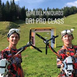 |
by Press on (#40231)
DR1 Racing, the global leader in professional drone racing, has unveiled the new Pro Class racing drone for the league’s upcoming 2018 season of the DHL Champions Series fueled by Mountain Dew. Measuring over 4 times larger than previous racing drones, the giant Pro Class drones will allow fans to follow the action better than […]
|
 |
by Press on (#40233)
Kespry today announced new capabilities as part of its drone-enabled roof inspection solution to further support the rapid and cost-effective resolution of residential roof claims. New capabilities include the automatic creation of roof dimension data that can be directly processed in Xactimate® to support more rapid repair estimation. In addition, enhancements to the Kespry iPad […]
|
 |
by Press on (#400NG)
MicaSense Altum is a new 3-in-1 solution that combines thermal, high-resolution, and multispectral imaging capabilities in one sensor. MicaSense releases Altum, its new top of the line sensor for professional-grade agricultural drone mapping. Altum captures synchronized multispectral and thermal imagery, enabling aligned outputs for advanced analytics. Altum’s multispectral imagers are the highest resolution integrated multispectral […]
|
 |
by Press on (#400BW)
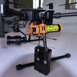
Gene Engelgau, Los Gatos, California The Fruity Chutes Matrice 200 and Matrice 210 Automatic Emergency Drone Parachute is lightweight, easy to use, and reliable. Designed with ease of use in mind, you can pack and load the parachute yourself; you do not need to send it back to the manufacturer after use. The parachute system […]
|
 |
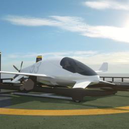
by Press on (#400BY)
After 12 years developing hydrogen propulsion systems for small unmanned aircraft, HES Energy Systems is today unveiling its plans for Element One, the world’s first regional hydrogen-electric passenger aircraft. One century after the start of commercial aviation HES is joining forces with a variety of partners to pioneer a new form of aerial mobility: quiet and zero carbon, […]
|
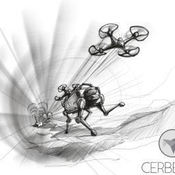 |
by Press on (#3ZZ3J)
Team CERBERUS awarded prestigious multi-year DARPA Subterranean Challenge grant RENO, Nev. – The University of Nevada, Reno, leading a team of international partners that includes ETH Zurich, University of California, Berkeley, Sierra Nevada Corporation and Flyability, has been awarded the prestigious DARPA Subterranean Challenge grant for the proposal “CERBERUS: CollaborativE walking & flying RoBots for […]
|
 |
by Press on (#3ZZ1H)
Company announces the maiden flight of its World’s first drone mounted Satellite Simulator October 1st – Atlantic Microwave, the U.K. based satellite communications innovator, has claimed a World’s first simultaneously in two ‘of the moment’ technologies. Well known globally for its innovative approach to satellite communications off-air testing, Atlantic Microwave has announced the maiden flight of […]
|
 |
by Press on (#3ZY9G)
Leading UAV Service Provider Aerodyne are proud to announce today that they have broken new ground on large-scale asset management and inspection projects around the world. Just over a year since they reported the completion of 30,000 inspections, the international drone-based solutions company has passed the 200,000 mark. This remarkable growth has been fueled by […]
|
 |
by Press on (#3ZY9J)
Boeing [NYSE: BA] and its subsidiaries Jeppesen and Aviall have joined with Robotic Skies, a leading commercial unmanned aircraft system (UAS) support services provider, to develop and deliver industry-leading supply chain management and optimization, analytics, and maintenance, repair, and overhaul (MRO) services for the commercial and civil UAS markets. “Teaming with Boeing will allow both […]
|
 |
by Press on (#3ZY9M)
Geomni, a Verisk (Nasdaq: VRSK) business, and DroneBase, the world’s largest global drone operations company, today announced a strategic alliance that adds DroneBase’s Pilot Network and API to Geomni’s fleet of fixed-wing aircraft to expand property inspections globally. “The insurance industry is beginning to tap into the power of drones, and aligning with Geomni should demonstrate the […]
|
 |
by Press on (#3ZY9P)
DJI, the world’s leader in civilian drones and aerial imaging technology, has been approved to offer Low Altitude Authorization and Notification Capability (LAANC) services for professional drone pilots. After a rigorous test and validation of DJI’s technology capabilities, the U.S. Federal Aviation Administration (FAA) on Monday announced its approval of DJI as a UAS Service […]
|
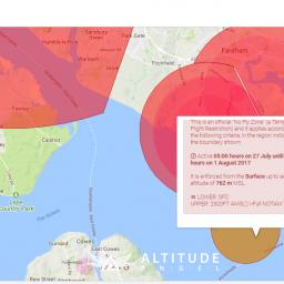 |
by Press on (#3ZXB6)
READING, UNITED KINGDOM – Altitude Angel, the global company defining Unmanned Traffic Management (UTM), today proudly announces its approval by the Federal Aviation Authority (F.A.A.) as a UAS Service Supplier (U.S.S.) of the Low Altitude Authorization and Notification Capability (L.A.A.N.C.). This is great news for Altitude Angel’s customers since full L.A.A.N.C. capability can now be […]
|
 |
by Press on (#3ZX50)
Las Vegas, Nevada- Announced today at the Commercial UAV Expo was the launch of the new mdLiDAR3000. It’s the newest LiDAR system from Microdrones that combines the heavy lifting power of the md4-3000 drone with a RIEGL LiDAR and a SONY camera for rapidly producing colourized point clouds. The new system is unique because it […]
|
 |
by Press on (#3ZX1S)
Microdrones hosted an open house event on Sept 21st at its new facility in Siegen, Germany. More than 200 guests attended, including neighbours, business partners and media contacts. Guests were welcomed to meet the team at Microdrones and see the work that is being done in Siegen for this rapidly expanding global company with sister offices […]
|
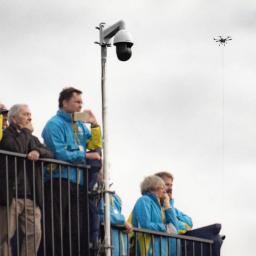 |
by Press on (#3ZX1V)
A tethered drone built by Elistair was used by the French authorities to ensure continuous aerial surveillance of one of the biggest international sports competitions, The Ryder Cup 2018 held in Paris from September 25 to September 30. « This is not golf, this is the Ryder Cup ». Every two years, the Ryder Cup […]
|
 |
by Press on (#3ZX1X)
There is just one month to go before the first FAI World Drone Racing Championships kicks-off in Shenzhen, China. Some 115 of the world’s best drone-racing pilots from 32 nations will converge on the tech city of Shenzhen in southern China for four days of high-calibre racing, 1-4 November 2018. Gold, silver and bronze medals […]
|
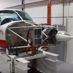 |
by Press on (#3ZSPN)
magniX to electrify Cessna Caravan in 2019. (For all the eVTOL pundits and BS renderings appearing, this to me is a more practical and obvious development. The most exciting thing I have seen in the electric space this year. (ed)) magniX, the company powering the electric aviation revolution, today announced the successful testing of its 350 horsepower […]
|