 |
by Press on (#441WM)
DJI, the world’s leader in civilian drones and aerial imaging technology, has signed a Memorandum of Understanding with the Polytechnic University of Turin in order to establish an official partnership in the fields of education and research. Celebrating the partnership, DJI has launched a short film that shows how drones are being used in a theoretical and […]
|
sUAS News
| Link | https://www.suasnews.com/ |
| Feed | http://www.suasnews.com/feed |
| Updated | 2026-07-22 05:30 |
 |
by Press on (#441FA)
The U.S. Department of Transportation’s Federal Aviation Administration (FAA) today announced Earl Lawrence’s promotion to the Agency’s Executive Director for Aircraft Certification. Lawrence was previously Executive Director for the FAA’s Unmanned Aircraft Systems (UAS) Integration Office. He succeeds Dorenda Baker, who retired Nov. 30 after a distinguished aviation safety career. Jay Merkle, Deputy Vice President […]
|
by Press on (#4412J)
Terra Drone Corporation (Shibuya-ku Tokyo CEO Toru Tokushige following as Terra-Drone) finalised the sponsor contract with CARTIVATOR Resource Management Association (following as CARTIVATOR) running ‘first flying car in Japan’ inventive projects named CARTIVATOR. ‘We are incredibly excited to be supporting CARTIVATOR in challenging for practical application of the flying car’ said Terra Drone’s COO Teppei […]
 |
by Press on (#4412K)
As event organisers look for new ways to amaze their customers, drone shows are becoming more popular than ever. Hundreds of light pixels in the sky, composing intricate patterns, words or even portraits in a delicate dance. Drone shows used to be a thing from the future, but in the past few years, they have […]
|
 |
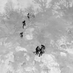
by Dr Gregory Crutsinger on (#43YTJ)
Like many people on November 8th, 2018, I was glued to the news about the explosive Camp Fire burning through the town of Paradise, California. At that point, I didn’t know just how devastating the fire would be, let alone that it would become the deadliest and most destructive wildfire in California history. No one […]
|
 |
by Press on (#43YTM)
Flock have partnered with ICARUS, a leading commercial flight school in the UK, to provide free drone insurance to training pilots. Today, Flock have announced that they have teamed up with ICARUS, an industry renowned commercial drone flight school. Working together, the two companies are lowering the barriers to entry for pilots entering the UK’s […]
|
 |
by Press on (#43YP4)
The British public remains sceptical about the use of drones, according to the latest figures released by the air traffic management service, NATS. Almost 80% of the 1,000 people surveyed by Ipsos MORI as part of NATS’ annual Aviation Index expressed concerns around privacy, while almost three quarters felt drones pose an ongoing safety risk […]
|
 |
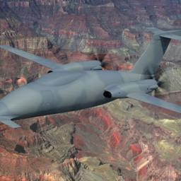
by Press on (#43Y24)
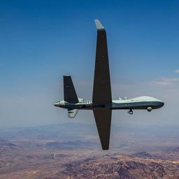
General Atomics Aeronautical Systems, Inc. (GA‑ASI) received a Special Airworthiness Certification in the Experimental Category from the FAA for its second MQ-9B SkyGuardian aircraft. The company-owned Remotely Piloted Aircraft (RPA) – registered as N191FP and known as YBC02 – joins the first SkyGuardian in support of the MQ-9B development program. This certification permits YBC02 to […]
|
 |
by Press on (#43Y25)
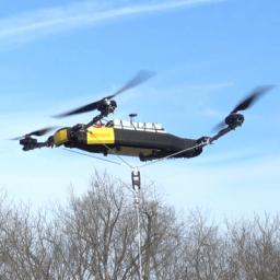
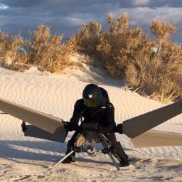
Lexington, Kentucky: Mobile Recon Systems today announces a new unmanned multi-rotor air vehicle (UAV) capable of lifting more than its own weight. This model, called “Dauntlessâ€, is designed to set new records for what multi-rotor UAVs can carry. At 78 pounds, the Dauntless has easily lifted an additional payload of 100 pounds as a tethered quadcopter. […]
|
 |
by Patrick Egan on (#43X4Y)
One of the new FAA mantras trifecta is “standards,†the other two are “we’re open for business†and “bring us a safety case.†I’ve touched on these before, and I’ll be writing another article addressing the absurdity (the good Lord knows we need some FAA leadership) as soon as I get done counting up my […]
|
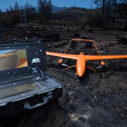 |
by Press on (#43W34)
ALTI UAS, world-leading unmanned aircraft developer and manufacturing company, launches a Search and Rescue version of the ALTI Transition VTOL UAV. This comes after some of the worst fires in South African history recently swept through the area. The ALTI Transition SAR ‘Orange’ is a specific version of the ALTI Transition designed for search and rescue missions. […]
|
 |
by Press on (#43VDM)
Klau Geomatics, industry leader in PPK hardware and post-processing software, announced today its new PPK software for the DJI Phantom4 RTK drone. The software enables professional users to achieve the most accurate and reliable results with their P4RTK drone without running it in RTK mode. RTK requires continuous communication between the drone and base station, […]
|
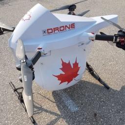 |
by Press on (#43VDP)
Drone Delivery Canada ‘DDC or the Company’ (TSX.V:FLT OTC: TAKOF), is pleased to announce that Air Canada Cargo’s, Mr. Tim Strauss, has joined DDC’s Advisory Board to assist the Company to execute its commercial strategy. Mr. Strauss currently serves as Vice President of Cargo for Air Canada, Canada’s largest domestic and international airline. Air Canada serves more than 200 airports on six […]
|
 |
by Press on (#43VBE)
A “Certifiable†(STANAG 4671-compliant) Ground Control Station (C-GCS) from General Atomics Aeronautical Systems, Inc. (GA-ASI) was used for the first time on October 4 to fly a Remotely Piloted Aircraft (RPA). The flight originated from Yuma, Arizona and flew GA-ASI’s MQ-9B SkyGuardian RPA. Aircraft flight critical functions were tested successfully, including hold modes, landing gear, flap operation, and […]
|
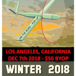 |
by Patrick Egan on (#43TFJ)
Post-FAA 2018 Reauthorization Drone Symposium and Pancake Breakfast. The venue is in the new US epicentre of Drones—Los Angeles, California, December 7th, 2018. We will meet for breakfast at the world famous Dinah’s Family Restaurant for pancakes, or pigs in a blanket if you’re not into the whole breakfast brevity thing. After breakfast, the […]
|
 |
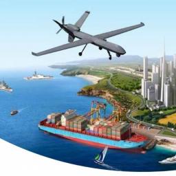
by Press on (#43TFM)
Drone Delivery Systems and FlytBase have just announced a partnership for the development of a precision landing kit, compatible with any delivery drone, to allow for secure and precise drone delivery to AirBox Home. AirBox is the world’s first smart drone delivery mailbox. Today, drones are readily being used to make deliveries in the medical […]
|
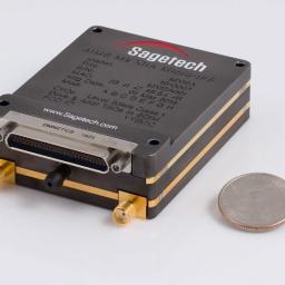 |
by Press on (#43T1F)
Sagetech Corporation, a maker of certified UAV avionics, this month demonstrated NATO Mode 5 encrypted interrogations/replies with a device weighing less than 6 ounces. The MX12B is an aviation transponder that enables small unmanned aircraft to interoperate in NATO military airspace, at minimal weight-cost. The event was hosted at a government facility near Patuxent River […]
|
 |
by Press on (#43SQB)
SimActive Inc., a world-leading developer of photogrammetry software, is pleased to announce the use of Correlator3DTM for a large-scale project by First Base Solutions. The software allowed the processing of 50,000 large-format images at 200MP, collected at a 10cm resolution, on a single standard PC. The size on disk for each image consisted of 765MB, […]
|
 |
by Press on (#43Q4C)
Disappointing results in light of a significant consumer drone market contraction Net income affected by the impairment of goodwill Development of a unique portfolio of companies focused exclusively on drones Action plan to retain €100m of cash by end-2019 Henri Seydoux, Parrot’s Chairman, CEO and leading shareholder, explains: “The end of this year is being complicated by a […]
|
 |
by Press on (#43Q4D)
Terra Drone Ltd, a global company with its headquarters in Japan, has acquired a majority stake in the leading European drone service provider Skeye. Skeye will become the European headquarters of Terra Drone. With this acquisition, Terra Drone has become one of the largest drone service company with more than 250 employees and presence in […]
|
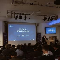 |
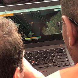
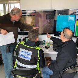
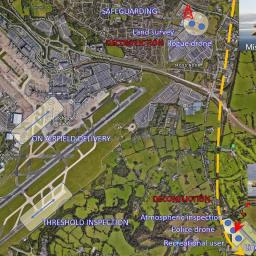
by Press on (#43J3Y)
On Wednesday 21st November 2018, to an exclusive delegation of over 120 influential people involved in the drone industry, Altitude Angel, NATS, Manchester Airport and our delivery partners collectively and successfully staged “Operation Zenithâ€: the most comprehensive demonstration of a UTM platform’s ability to unlock the full potential of drones. From all around the world, delegates […]
|
 |
by Press on (#43J0D)
This course focuses on the knowledge and skills required by personnel who may be involved with Autonomous Vehicle or UAS operations – investigating future occurrences involving these systems, and those exploring the potential application of drones for accident investigation purposes. This practical course benefits from significant participation by members of the RPAS industry, academics working […]
|
 |
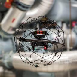
by Press on (#43J0F)
e2E Satcom Limited (e2E), a UK-based provider of low-cost, solutions to the satellite communications industry has successfully completed its first over-the-air flight test of their newly launched UAS-I SATCOM communication node for Unmanned Aircraft Systems (UAS). This is based on e2E’s innovative e2Eaccess technology that has low size, weight and power at its core. e2E […]
|
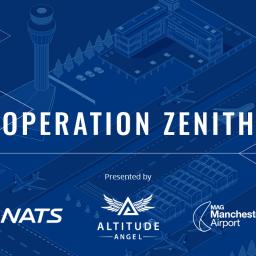 |
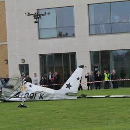
by Press on (#43J0H)
Operation Zenith, an ambitious drone demonstration at Manchester Airport, has shown that drones can be flown safely alongside manned aircraft in controlled airspace. The drones, overseen by NATS air traffic controllers communicating with drone operators via Altitude Angel’s GuardianUTM Airspace Management Operating System, successfully demonstrated how a series of on-airfield tasks can be performed without […]
|
 |
by Gary Mortimer on (#43J0J)
It is with a deal of sadness that I must report that the P1.HH Hammerhead maybe no more. Italian manufacturer Piaggio Aerospace has asked to be put in receivership. A delay by the Italian Airforce in picking up the speedy canard is being blamed. Patrick and I marvelled at the Hammerhead when it made it’s […]
|
 |
by Press on (#43F7A)
In partnership with Cobham and Starburst, Inmarsat’s UAV Pop-up lab is an initiative to demonstrate the value of resilient satellite communications in the unmanned aerial vehicle sector, with a focus on beyond line of sight (BLOS) and remote operation connectivity on platforms above 5 kilogrammes in payload mass. Five companies will be selected to integrate […]
|
 |
by Press on (#43F7C)
Boeing [NYSE: BA] and SparkCognition today announced plans to launch SkyGrid, a new company that will enable the future of urban aerial mobility. Based in Austin, Texas, SkyGrid will develop a software platform to ensure the safe, secure integration of autonomous cargo and passenger air vehicles in the global airspace. Using blockchain technology, AI-enabled dynamic traffic routing, data […]
|
 |
by Press on (#43F7E)
DJI, the world’s leader in civilian drones and aerial imaging technology, today demonstrated how its AeroScope remote identification technology can be a key element in an unmanned traffic management (UTM) system that safely integrates drones and traditional aircraft into the same airspace. The AeroScope solution was featured in Operation Zenith, a full-scale test of how […]
|
 |
by Press on (#43D21)
UMS SKELDAR, the world-class provider of rotary Unmanned Aerial Vehicle (UAV) solutions and avionics software, has joined forces with ESG to spotlight capabilities of UMAT rotary VTOL UAV, based on the UMS SKELDAR R-350, in pioneering airborne teaming with German Armed Forces helicopter. UMS SKELDAR has joined forces with partner ESG to complete a range of […]
|
 |
by Press on (#43D23)
ISO Draft International Standards for Drone Operations are formally released today for a public consultation, with drone professionals, academics, businesses and the general public is invited to submit comments by 21 Jan 2019 with final adoption of these Standards expected in the US, UK and worldwide in 2019. Today’s announcement by ISO is the first […]
|
 |
by Press on (#43CSF)
TOOELE CITY- Deseret UAS has signed a memorandum of understanding (MOU) with the unmanned aerial systems (UAS) company, ElectraFly. This Utah-based company is developing a personal flying vehicle that has the potential to revolutionize the unmanned aerial systems (UAS) industry. Under the agreement, ElectraFly will begin flight testing on Deseret UAS ranges early next year. This […]
|
 |
by Patrick Egan on (#43CQ4)
* This was written before the DJI and Airmap break up, Red Hat, IBM buy out and Uplift four-person onboarding. Things happen so fast around here; it changes by the day. Red Hat got enough bread from IBM that they could put PH on life-support for just about ever and not bat an eye. So, […]
|
 |
by Press on (#43B1W)
InstantEye Robotics is pleased to announce it has secured a contract with the Defense Logistics Agency (DLA) in support of PMA-263, the Navy and Marine Corps Small Tactical Unmanned Aircraft Systems (sUAS) Program Office, to field 32 InstantEye Mk-3 GEN5-D1 sUAS systems (64 aircraft). This procurement is being executed in support of a United States […]
|
 |
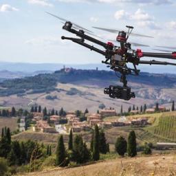
by Press on (#43AM2)
vHive, the developer of a cloud-based software solution that enables enterprises to deploy autonomous drone hives to digitize their field operations and assets, announced today the enhancement of its fully automated workflow for cell tower inspection using drones to also support guy wire towers. “Millions of cell towers worldwide require ongoing inspection and surveying as […]
|
 |
by Press on (#43AB8)
This two-week MOOC covers key concepts related to small unmanned aircraft systems (sUAS), including basic types, characteristics, applications and current and future uses. It is designed for users with commercial, private/recreational, and public and educational interest in sUAS applications. Specific importance is placed on safety of flight within the National Airspace System (NAS), including where […]
|
 |
by Press on (#43AB9)
General Atomics Aeronautical Systems, Inc. (GA‑ASI) has been notified that the Government of Belgium has approved Belgian Defense to begin negotiations with the U.S. Government to acquire the MQ-9B SkyGuardian Unmanned Aircraft System (UAS). “We look forward to providing our unmanned aircraft systems to meet Belgium’s mission requirements, while also supporting the NATO Alliance,†said […]
|
 |
by Patrick Egan on (#438QS)
The sUAS News Podcast series carries on its long tradition of interviewing and learning from experts in the unmanned technology field, and, in this instalment, we learn about FLIR products and remote sensing. Our guests are Randall Warnas, Global sUAS Segment Leader FLIR, and Garret Bryl, UAS Pilot for the Joshua Fire and Public Safety […]
|
 |
by Gary Mortimer on (#438JX)
I was going to sit down today and write about Involi, a company I had heard of but not seen in action until the Lake Victoria Challenge. A power cut has made that easier to do, more of that later. Involi is a Swiss company who have set out to create their own network of […]
|
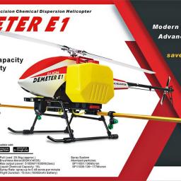 |
by Press on (#438BJ)
ALIGN DEMETER E1 Agricultural Helicopter is revolutionizing the way agriculture is done. It’s an advanced helicopter for modern green farming and spraying that can be completed up to 29 acres per hour; 60 times faster than traditional machinery. Specially inherit “Helicopter†body design, when it rotates, the strong airflow will carry the spraying directly down […]
|
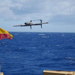 |
by Press on (#437VC)
A hybrid quadrotor (HQ) UAS platform with the ability of vertical take-off and landing (VTOL) and conversion to fixed wing (FW) flight allows for operations from ships, where launch and recover space is constrained while maintaining the range and endurance of a FW aircraft. The HQ technology eliminates the need for rail launchers and aerial […]
|
 |
by Press on (#4364H)
Collaboration on UAM Airspace Integration Research and Development The National Aeronautics and Space Administration (NASA) has conducted research on a multitude of Air Traffic Management (ATM) areas over the past several decades. The concepts, technologies, and procedures developed through these efforts have meaningfully benefited the flying public and the aviation community in the form of […]
|
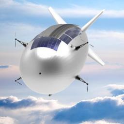 |
by Press on (#4364J)
Is it a bird? Is it a plane? No, it’s a High-Altitude Pseudo-Satellite (HAPS) — an uncrewed airship, plane or balloon watching over Earth from the stratosphere. Operating like satellites but from closer to Earth, HAPS are the ‘missing link’ between drones flying close to Earth’s surface and satellites orbiting in space. They float or […]
|
 |
by Press on (#434J5)
Heliguy is delighted to announce that it has won a prestigious prize at the renowned North Tyneside Business Awards 2018, thanks to the company’s outstanding customer service and passion to develop the drone industry. The North Shields-based UAV expert was presented with the Retail and Service Provider Award at last night’s ceremony, staged at the recently […]
|
 |
by Press on (#433EP)
On November 21, 2018 – something special is happening in the UK in the realm of UTM and ATM integration. Operation Zenith, headlined by the UK’s Air Navigation Service Provider (ANSP) NATS and the premier global Unmanned Traffic Management (UTM) System provider, Altitude Angel, Zenith will showcase a view of the future of air traffic management. uAvionix is a […]
|
 |
by Press on (#433ER)
Drone insurance specialist Moonrock Insurance has announced an exclusive partnership with Swiss Drone manufacturer Flyability. The partnership will allow all commercial pilots flying Elios drones – Flyability’s drone designed for the inspection and exploration of the most inaccessible places – to obtain a tailor-made insurance product for their drone through Moonrock Insurance. Elios drones are built to work […]
|
 |
by Gary Mortimer on (#432WK)
The National Police Air Service (NPAS) and CAA in the East of England have successfully prosecuted a case against a drone user flying BVLOS. Sergej Miaun flew his DJI Phantom 4 more than half a mile to go and have a look at a Police helicopter searching for a missing person. He flew directly underneath […]
|
 |
by Press on (#431BK)
The Aviary Project Launch Event is bringing together all stakeholders of eVTOL technologies to accelerate the adoption of flying taxis which will alleviate urban problems such as congestion, air pollution, and excessive commuting. With professionals from vehicle design corporates & startups, airspace integration companies, regulatory landscape, consultancies, and government agencies attending, the event brings together […]
|
 |
by Press on (#4309H)
Verity Studios, the global leader in indoor drone technology, has brought a display of dancing drones to The Dubai Mall’s 10 Year Celebrations. Titled Talisman, the show is running daily until 28th November, with 44 autonomous Lucie® micro drones flying together to form clusters of light, flying strobes and even fireworks in the Star Atrium, […]
|
 |
by Press on (#42ZV7)
RAS Security Group joins leading counter drone tech vendor from Tel Aviv, Israel at one of California’s iconic stadiums to demonstrate next-gen drone detection and take down tech. Hermosa Beach, Calif. (October 23, 2018) – RAS Security Group and several of their clients joined a leading counter-drone technology vendor at one of California’s most recognizable […]
|
 |
by Press on (#42ZKH)
Asylon and O.W.L. are announcing that they have completed a formal partnership and advanced integration of their DroneCore Security and GroundAware Radar Systems. Asylon’s DroneCore is a globally scalable autonomous A.I. powered security drone solution optimized for remote command and control. O.W.L.’s GroundAware radar facilitates an event-based layered security approach that can autonomously detect and […]
|