 |
by Press on (#42Y6M)
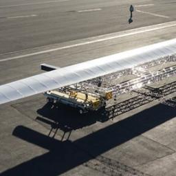
Aurora continues its nearly 30-year legacy of advancing autonomous systems with Odysseus, the world’s most capable solar-powered autonomous aircraft. Powered only by the sun, Odysseus is an ultra-long endurance, high-altitude platform built for groundbreaking persistence. Utilizing advanced solar cells and built with lightweight materials, Odysseus can effectively fly indefinitely – all powered by clean, renewable […]
|
sUAS News
| Link | https://www.suasnews.com/ |
| Feed | http://www.suasnews.com/feed |
| Updated | 2026-07-22 05:30 |
 |
by Press on (#42XWR)
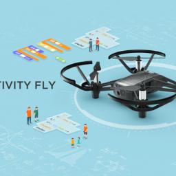
Ryze Tech, the creator of the Tello mini-drone, announced the launch of Tello EDU, a programmable unit that expands the educational opportunities with support for additional programming languages and drone swarms. Tello EDU is now available worldwide at store.dji.com, apple.com, and in select Apple retail stores worldwide. Since it launched earlier this year at CES, […]
|
 |
by Press on (#42XKF)
British troops will today begin testing out over 70 examples of futuristic technology including enhanced surveillance drones and unmanned vehicles on the fields of Salisbury Plain, Defence Secretary Gavin Williamson has announced. The game-changing Autonomous Warrior experiment will last four weeks and test a range of prototype unmanned aerial and autonomous ground vehicles which aim […]
|
 |
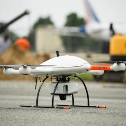
by Press on (#42XKH)
AviSight, Inc., the leader in unmanned industrial inspection and advanced data solutions, added yet another certification to its resume this week. American Bureau of Shipping (ABS), the leading provider of classification and technical services to the offshore industry, has awarded AviSight certification to support survey-related inspections on all types of rigs using drones. AviSight is […]
|
 |
by Press on (#42TSA)
Alpha Unmanned Systems (alphaunmannedsystems.com) announced today that it has selected Robotic Skies, Inc. (roboticskies.com) to develop and implement a global support plan for its current and future commercial UAVs, currently featuring the Alpha 800 unmanned helicopter. Robotic Skies will provide a warranty program and field support management for Alpha Unmanned customers through its network of […]
|
 |
by Press on (#42TSB)
The continuing growth of Unmanned Aircraft Systems (UAS) within the National Airspace System (NAS) presents challenges for the Federal Aviation Administration (FAA) in maintaining the world’s safest aviation system while fostering innovation. FAA has processed more than 1.1 million UAS registrations for commercial operators and hobbyists since December 2015. Further, the number of UAS sightings […]
|
 |
by Gary Mortimer on (#42TGH)
Yuneec today announced that it has been named a CES® 2019 Innovation Awards Honoree for the Yuneec Mantis Q drone (the first of its kind with voice control) in the robotics and drones product category. The announcement was made during CES Unveiled New York last night, an invite-only tech event bringing together top media, exhibitors and industry leaders for a […]
|
 |
by Press on (#42TGK)
Today, ArcBlock (https://www.arcblock.io), the leading application development platform for decentralized applications (DApps) and blockchain-enabled services announced that it has officially launched a new strategic partnership with Soar (https://www.soar.earth). Soar is working to create the world’s first decentralized Super-map using blockchain technology including the delivery of a new decentralized platform for high-resolution drone, aerial, and satellite […]
|
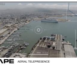 |
by Press on (#42SDD)
Cape, the leading cloud platform for drone telepresence and data management, today announced a partnership with ConnexiCore to provide end-to-end aerial telepresence and intelligence solutions for companies across industries, including public safety, oil and gas, construction, infrastructure, and insurance. As part of the Cape reseller program, ConnexiCore customers can now fully leverage the Cape Aerial […]
|
 |
by Press on (#42RXZ)
MyDefence Communication announces the successful integration of Counter Unmanned Aerial System (UAS) technology in vehicle platforms for military forces. The integration of the drone sensors allows military operators to effectively detect and defeat enemy drones used for reconnaissance or as weapon delivery systems. MyDefence has developed advanced, networked radio-frequency (RF) sensors, and has worked closely […]
|
 |
by Patrick Egan on (#42KV0)
The following hardball (and softball too) questions took three-plus weeks (and in some cases 6 plus years) for the FAA to answer as they had to ask around the various compartments, nooks and crannies of the Caerbannog. As is usually the case in the fluid world of the drone, more questions pile up as stories […]
|
 |
by Press on (#42KV2)
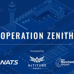
This demonstration of Unmanned Traffic Management (UTM) will be held at Manchester Airport, where drone flights will be safely integrated with manned aviation within and near the airport. The demonstration will be live-streamed to the Royal Aeronautical Society. Operation Zenith is the codename for a programme of live demonstrations of Air Traffic Management (ATM) and […]
|
 |
by Press on (#42KV4)
Company Announces Results of Apple Pollination Testing Syracuse, NY – Dropcopter recently received its Part 137 Exemption from the Federal Aviation Administration to operate unmanned aircraft for spray operations in the United States. The company has new evidence to that its unique pollination capabilities can result in better crop yields and anticipates that its new […]
|
 |
by Press on (#42KCR)
The Espect is a mini-sized quadcopter which adopts EWATT’s proven eWise flight control and propulsion system. Combined with our industrial-grade visible light & thermal imaging cameras and GCS (Ground Control System), the Espect excels in industrial and commercial purposes: power line & Telecommunication station inspection, police reconnaissance and law enforcement, fire reconnaissance, search & rescue. […]
|
 |
by Press on (#42KCT)
A derailed train lies on its side. Casualties are trapped among the wreckage, desperate for help. It’s a critical situation, with every minute crucial to survival. As part of the rescue operation, the emergency services fly a drone to the crash site, allowing officers to analyse the carnage from a safe distance and to provide […]
|
 |
by Press on (#42HQG)
NextNav’s 3D Location Service (MBS) Brings Accurate 3D Geolocation, Navigation and Timing to GPS-Challenged Areas SUNNYVALE, CA – November 8, 2018 – NextNav, the pioneer in 3D geolocation services, today announced that its Metropolitan Beacon System (MBS) service has been accepted for use by National Aeronautics and Space Administration (NASA). NASA will use NextNav’s MBS network as part […]
|
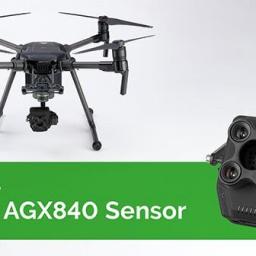 |
by Press on (#42HKJ)
Sentera announces a pre-order opportunity for the AGX840, a powerful update to Sentera’s popular 4-channel multispectral camera, engineered specifically for DJI Enterprise drone products. Powered by DJI SKYPORT and integrated with a high-speed brushless gimbal for exceptional image stability and control, AGX840 brings outstanding multispectral performance to Matrice 200 series platforms. Sentera’s AGX840 is an ideal […]
|
 |
by Press on (#42GH2)
EIMA International (Bologna, ITA) – Parrot, the leading European drone group, today announces Parrot Bluegrass Fields, an end-to-end agriculture drone solution, which provides farmers, agronomists and researchers with the insights they need to boost the quality of their crops and maximise yields. Part of the Parrot Business Solutions portfolio, Parrot Bluegrass Fields brings together today’s popular Parrot Bluegrass drone with the all-new ParrotFields mobile […]
|
 |
by Patrick Egan on (#42EWG)
I was finally able to meet FAA UASIO Director Earl Lawrence in person at the NASA UAM GC meeting in Seattle. I know you are probably scratching your heads saying, “Wow it took you that long? I met him at such and such show.†Please understand, I don’t go to the carpetbagger shows because the […]
|
 |
by Press on (#42EDC)
Astronaut and pilot-designed controller by Fluidity Technologies makes drone flight more precise, intuitive and easier to learn HOUSTON, November, 2018 – Drone pilots, from commercial experts to novices, can now increase their flight precision and improve their image/video quality with a first-of-its-kind single-handed controller from Fluidity Technologies. The FT Aviator drone controller was conceptualized and […]
|
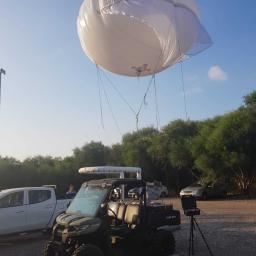 |
by Press on (#42EDE)
The SkyStar 120 Ground Control Station is mounted on an ATV that can drive through rough terrain while carrying the inflated aerostat, or while the aerostat is already flying in the air The Israeli-based aerostat company RT LTA Systems Ltd. introduces a new member of the SkyStar aerostat family: SkyStar 120. The new micro-tactical aerostat […]
|
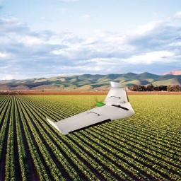 |
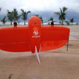
by Press on (#42DH5)
Fixed wing drone significantly increases productivity and data analysis performance for planning and managing agriculture activities. Offers precise automatic geolocation capabilities, real-time processing and control in a fully-integrated, easy-to-use solution. TOULOUSE, France. – November 6, 2018 – Delair a leading supplier of commercial drone solutions, today announced a new drone platform specifically optimized for the […]
|
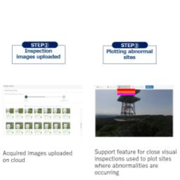 |
by Press on (#42CRJ)
SENSYN ROBOTICS, Inc. (head office: Shibuya-ku, Tokyo; President & CEO: Taishin Demura), the company known for providing commercial robotics solutions for businesses and local governments, will start offering a beta version of its new TOWER CHECK, a package for tower inspections incorporating the use of drones. The package contains a camera-equipped drone that is operated […]
|
 |
by Press on (#42BWY)
RelmaTech has designed and developed an innovative solution to meet any future regulatory requirements for UAS to broadcast their position and unique ID without relying on a communications network to carry that data. RelmaTech’s leading-edge Direct Broadcast solution – a prototype version of which has been demonstrated to key people in the US Federal Aviation […]
|
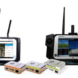 |
by Press on (#42BJC)
Mobilicom Ltd., a global mission-critical-communications solution provider, will present its full SkyHopper product suite, including the communication data links (SkyHopper PRO and SkyHopper ONE), the Integrated Video Processing solution (SkyHopper PRO V), the Viewers (SkyHopper VU) and Controller (SkyHopper ControlAIR) at the Commercial UAV Show in London. Mobilicom’s SkyHopper family of solutions have been implemented […]
|
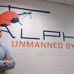 |
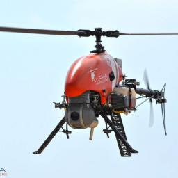
by Press on (#42BJD)
Spanish helicopter UAV company, Alpha Unmanned Systems, strengthens its national and international sales efforts through the incorporation of a new Senior Marketing professional to lead its corporate marketing. With 20+ years of professional marketing experience, Carlos Girón knows the tools and messaging requirements that Alpha’s international growth requires. Well versed in print and digital communications, […]
|
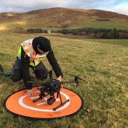 |
by Press on (#42BJF)
Drones are taking life-saving in Scotland to pioneering new heights. For the newly-formed Search and Rescue Aerial Association Scotland (SARAA-Scotland) is to use the remote-controlled craft to save people who are lost, missing or injured. It is thought to be one of the most significant developments in mountain rescue since search dogs were introduced in […]
|
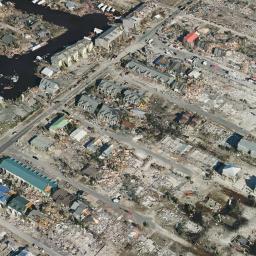 |
by Press on (#42BFM)
SimActive Inc., a world-leading developer of photogrammetry software, has partnered with Midwest Aerial to perform damage assessment of Hurricane Michael. Correlator3DTM was used to process large format imagery collected by Midwest over Mexico Beach, Florida. The joint effort resulted in highly precise geospatial data, including a DSM, an orthomosaic and a 3D model. “This is […]
|
 |
by Press on (#429HQ)
Swift Engineering, Inc. flew the first fully autonomous flight demonstration in the port city of Kobe, Japan on July 21, 2018. In attendance during the event was Governor of the Hyogo prefecture, Toshizo Ido, and Mayor of Kobe City, Kizo Hisamoto as well as other government officials and media. The flight took place in Meriken […]
|
 |
by Press on (#429D2)
PrecisionHawk, Inc., a leading provider of drone technology for the enterprise, today announced that it has purchased Uplift Data Partners. Uplift specializes in the delivery of turnkey inspection services for construction, building information management (BIM) and real-estate. Uplift has provided drone services for leading national and global brands. Uplift’s nationwide network of commercially trained drone […]
|
 |
by Press on (#4298R)
Special Discount Up To £100 (€110) On DJI Drones, Handheld Products And Goggles RE DJI, the world leader in civilian drones and aerial imaging technology, will offer discounted prices on its drones, handheld products and accessories, as part of its Black Friday promotion. The special offer will be available on Spark Combos, Mavic Air and […]
|
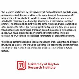 |
by Patrick Egan on (#4298T)
The egregious DJI demand letter makes people wonder just who is in control of the airspace integration narrative. The reality of the situation is that person works for DJI, which is a Chinese Toy Company. The man that conducted the research does impact physics research at UDRI for a living, his bio is below. We […]
|
 |
by Press on (#4296F)
Rudi Browning from Australia has been crowned FAI World Drone Racing Champion after a stunning four days of competition in Shenzhen, China. The 15-year-old pilot beat 127 other drone racers from 34 countries to win the title and the prestigious FAI gold medal in a final race that was watched by tens of thousands of drone […]
|
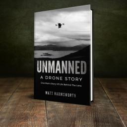 |
by Press on (#4290X)
As the drone show season kicks off in the UK, here is a gift for die hard drone fans, amateurs and professionals. Aerial filming with drones comes alive in the recently released ‘Unmanned – A Drone Story’ by Matt Harmsworth. As a special offer, ‘Unmanned’ can be downloaded for free from Kindle between November 6-9,2018. […]
|
 |
by Press on (#428TC)
Aireon LLC and FlightAware today announced thatGlobalBeaconSM is live and providing airlines with global flight tracking ahead of the International Civil Aviation Organization (ICAO) Global Aeronautical Distress Safety System (GADSS) recommendations, which will be effective November 8, 2018. GlobalBeacon provides airlines with minute-by-minute global aircraft tracking for their aircraft at all times, anywhere in the world. GlobalBeacon is […]
|
 |
by Press on (#427PR)
We are pleased to announce that Dassault Systèmes and Delair, a leading supplier of commercial drone solutions have signed a collaboration agreement confirming our intentions to combine Dassault Systèmes 3DEXPERIENCE platform, GEOVIA solutions and relevant drone-based technologies developed by Delair, and cooperatively promote these solutions for the mining and construction industries. “In just a few years, companies of […]
|
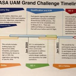 |
by Patrick Egan on (#424T4)
Going in I don’t know that I could be called sold on the Jetsonian flying car thing concept. Not that I don’t want two, I just see a few “reality†hurdles to overcome. NASA Airworthiness, search for: NASA AFG-7900.3-001 Out of the gate, we have a more serious crowd here. Most of the attendees understand […]
|
 |
by Press on (#4247C)
Dubai, UAE- As part of an ongoing global expansion, Microdrones has acquired geomatics service provider Navmatica Middle East (ME). Since 2012, Navmatica ME has provided services and custom software development, with a focus on geodetic positioning, airborne mapping, mobile mapping, and indoor mapping. Microdrones President Vivien Heriard-Dubreuil explains, “With an office and team in Dubai, […]
|
 |
by Press on (#423V4)
DroneUp, LLC attended The Virginia Governor’s Transportation Conference (GTC) at The Hilton Main in Norfolk, Virginia for the states annual gathering of transportation professionals. Attendees gather each year to be updated on the latest developments in the industry from both the private and public sectors. CEO, Tom Walker, was one of five panellists alongside Cathy […]
|
 |
by Press on (#4215R)
DJI Investigating Cause Of Small Number Of Batteries Reporting Incorrect Power Levels DJI is investigating reports that a small number of TB50 and TB55 batteries have shown incorrect power levels that have led to loss of power mid-flight. Flight safety and product reliability are our top priorities, and we are advising customers to fly with caution when […]
|
 |
by Press on (#4215T)
Terra Drone Corporation (SHIBUYA-KU TOKYO CEO Toru Tokushige following as Terra Drone) established a new branch in South Africa specializing in drone solutions for underground and surface mining. Terra Drone is a leading global commercial drone technology company focused on providing cutting-edge, smart-mining solutions, which improve safety, reduce down-time, reduce costs, and increase the quality […]
|
 |
by Press on (#420RV)
Leading Israeli automated drone startup Airobotics today announced a $30M Series D round of funding bringing its total capital raised to $101M. Pavilion Capital is leading the round, joining a list of prominent investors, including BlueRun Ventures, Charles River Ventures and OurCrowd, as well as additional private investors. The new round of funding will be used to […]
|
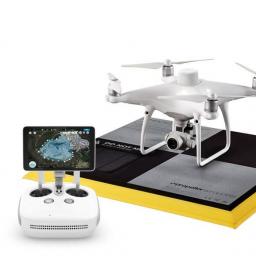 |
by Press on (#420RX)
Propeller, a cloud-based drone analytics company, today announced a partnership with DJI, the world’s leader in civilian drones and aerial imaging technology, to create the Propeller PPK Solution leveraging the DJI Phantom 4 RTK drone. This solution provides customers in the civil, mining, aggregates, and waste management industries with a reliable and fully integrated drone mapping […]
|
 |
by Press on (#42076)
Small Unmanned Aircraft DJI Battery TB50 and TB55 In-Flight Power Failures Introduction 1.1 This Safety Notice supersedes and revokes Safety Notice SN–2018/008. 1.2 This Safety Notice applies to operators of multi-rotor small unmanned aircraft utilising DJI battery model TB50 or TB55, including all DJI Matrice 200 series (which includes the 200, 210 and 210 RTK […]
|
 |
by Gary Mortimer on (#41YPM)
Mwanza, Tanzania, Tuesday 30th October 2018. Wingtra today helped push forward commercial drone operation in East Africa completing a fully autonomous flight of 22km across Lake Victoria to Juma Island. On arrival it landed on the beach. Mwanza City is a port city of 3.5 million people that serves not only the fishing community on […]
|
 |
by Press on (#41YEY)
SALINA – The Kansas Department of Transportation is starting the testing phase of the Integration Pilot Program this week. Flights by Iris Automation will focus on enabling new detect and avoid capabilities for drones. Iris Automation will be testing its collision avoidance technology in the airspace above Gypsum’s farmlands. The technology uses computer vision and […]
|
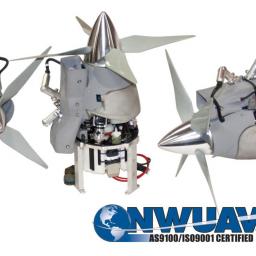 |
by Press on (#41YF0)
McMinnville, OR: Northwest UAV (NWUAV), the largest UAV propulsion system manufacturer in the U.S., has successfully completed the first phase towards Federal Aviation Administration (FAA) 14 CFR Part 21 Type Certification in support of the NW44 type certification program. Members of the FAA team, which comprised FAA Flight Standards (AC-AW), AIR UAS Programs and Procedures […]
|
 |
by Press on (#41YCR)
DJI, the world’s leader in civilian drones and aerial imaging technology, today opened the doors to its third annual AirWorks enterprise drone conference by showcasing new hardware, software and strategic partnerships, expanding the global DJI ecosystem to help more enterprises embrace the benefits of aerial productivity. In presentations at the AirWorks 2018 keynote address today, […]
|
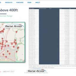 |
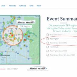
by Patrick Egan on (#41YCT)
What did the heck happen in Albuquerque at the annual Balloon Fiesta? Local news reported that the Balloon Fiesta was a “no drone zone,†plus the authoritarian “don’t even think about it†complete with fines and jail time. DJI had stated that their partners Aerial Armor had identified some 40 drones and not the 450 […]
|
 |
by Press on (#41YCW)
The latest drafts of the EASA regulations for unmanned aircraft were published recently by the European Commission and contain a significant and positive development for model flyers. DG MOVE (the European Transport Commission) submitted a proposal to remove model flying conducted within Associations/Clubs from the EASA regulations and this seems to have gained acceptance. The […]
|