 |
by Press on (#3X73N)
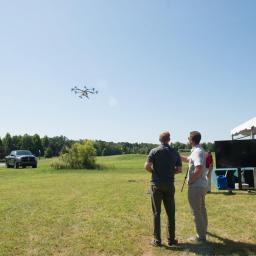
Mobilicom’s Mobile Mission Management System is part of Mobilicom’s Holistic framework for disaster relief situations which reduces the crew overload ISDEF Japan 2018, stand C-04 [August, 2018]: Mobilicom Ltd., a global mission-critical-communications solution provider, will present its Mobile Mission Management System, which is part of Mobilicom’s Holistic framework for disaster relief situations, at ISDEF Japan […]
|
sUAS News
| Link | https://www.suasnews.com/ |
| Feed | http://www.suasnews.com/feed |
| Updated | 2026-07-22 03:45 |
 |
by Press on (#3X707)
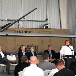
Dignitaries, industry leaders gather to mark new BVLOS capabilities for large UAS (Grand Forks, N.D.) – Aug. 20, 2018 – Grand Sky, the first and only fully operational commercial unmanned aerial systems (UAS)-focused research and development park in the U.S.,announced beyond visual line of sight (BVLOS) flight operations for large UAS have begun at the […]
|
 |
by Press on (#3X5WP)
The Sky Guys, Canada’s top drone operator, announced this week they have been granted a Special Flight Operations Certificate (SFOC), a permit for commercial Unmanned Aircraft System (UAS) flights, for its landmark development project, the DX-3 “Vanguardâ€. The permit allows The Sky Guys to perform testing that will put the DX-3 through critical elements of integrated flight testing, including […]
|
 |
Aerodyne Group announces entry into Latin America with new regional headquarters in Santiago, Chile.
by Press on (#3X5D5)
Aerodyne Group are pleased to announce today that they have consolidated their presence in Latin America with a dedicated regional headquarters in Santiago, Chile. Aerodyne Chile becomes the latest addition to the Aerodyne Group, at a time when they are experiencing unprecedented growth and demand for solutions from around the world. From their base in the central […]
|
 |
by Press on (#3X5D7)
The FAA, Department of Defense, and certain members of congress are looking to remove a current section of the FAA Modernization and Reform Act that directly protects model aviation hobbyists. This protection called “Rule 336†exempts those involved in model aviation for “hobby & recreation†from serious & unnecessary regulation from the FAA. The FAA […]
|
 |
by Press on (#3X592)
RALEIGH – The N.C. Department of Transportation will hold a public meeting in Raleigh Aug. 30 to provide information about its program to test the use of commercial drones for the delivery of medical supplies. The NCDOT was selected in May as one of only 10 participants in the Federal Aviation Administration’s Unmanned Aircraft Systems (UAS, […]
|
 |
by Press on (#3X209)
Neil Kidd, Chief Technology Officer Altitude Angel There are some substantial changes to the airspace around San Francisco. Most of these changes are to airspace above 400’, but the most significant change for drone operators is that the Class B volume around SFO changed shape. This is particularly important as Class B affects both Part […]
|
 |
by Dr Gregory Crutsinger on (#3X0QC)
The Carr fire was my second trip to a disaster zone in California as a data analyst supporting public agency UAV teams. In both this fire and the Tubb’s fire in Santa Rosa last October, my role has been to coordinate drone data capture and mapping products to the right people across the disaster management […]
|
 |
by Press on (#3X0C5)
VSA working to create high-tech jobs and partnerships with area universities Valkyrie Systems Aerospace (VSA), a cutting-edge developer of manned/unmanned aerial platforms, is proud to announce an exciting partnership with the State of Oklahoma. This partnership will ultimately accommodate manufacturing facilities, as well as flight operations and training in the greater Oklahoma City area. https://youtu.be/ur3i4G-ezC0 […]
|
 |
by Press on (#3WZYV)
FAI, the World Air Sports Federation, announces the full list of expert speakers attending the FAI International Drones Conference and Expo 2018 at the EPFL Rolex Learning Centre in Lausanne, Switzerland. Global experts from throughout the drone world will gather to share their expertise at the two-day conference taking place on 31 August and 1 […]
|
 |
by Press on (#3WZQ8)
Influential commission mulls state-level measure that could prove problematic for burgeoning U.S. drone industry. Many of today’s routine drone flights could be redefined as “aerial trespass†under a law proposed by a commission known for its influence with state legislatures, cautioned veteran LeClairRyan aviation attorneys during a webinar attended by more than 300 aviation and […]
|
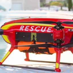 |
by Press on (#3WYGV)
As part of the Lifeguard team and now ever present on the beach in the port of Sagunto, Spain, the Auxdron Lifeguard Drone was ready and waiting as one of the Lifeguards sounded the alarm that there were people caught in an undertow and looked like they needed help. This event happened on Wednesday the […]
|
 |
by Rob Thompson on (#3WYGX)
The prison industry’s operations are not a widely known to the general public, for starters most assume the state or federal government runs the prison, this is true that there are both federal and state-owned prison facilities, but there are also private facilities that outnumber those ran by the government. Private facilities are run by […]
|
 |
by Press on (#3WYBZ)
The Choctaw Nation of Oklahoma (CNO) hosted a successful unmanned aircraft system (UAS) or “drone†demonstration yesterday in Stringtown, Oklahoma as part of the FAA UAS Integration Pilot Program (IPP). The IPP is intended to safely integrate drones into the national airspace system and accelerate economic growth opportunities associated with commercial drone operations. Today’s demonstration […]
|
 |
by Press on (#3WY6V)
UMS SKELDAR wins contract to deploy from Corvette Class 130 in 2019; package focused on pioneering NATO-compliant heavy fuel engine rotary VTOL (Vertical Take-Off and Landing) UAVs (Unmanned Aerial Vehicles) and at-sea training. UMS SKELDAR, the world-class provider of rotary Unmanned Aerial Vehicle (UAV) solutions and avionics software has been awarded a procurement contract through […]
|
 |
by Press on (#3WXSM)
ZURICH – Verity Studios AG, the global leader in indoor drone technology, announced today that swarms of Lucie micro drones are performing with Drake in his 2018 Aubrey & the Three Migos Tour. Grammy award-winning Canadian artist Drake is one of the best-selling rappers of the 21st century. Performing to audiences of more than 50,000 […]
|
 |
by Press on (#3WWJQ)
Intel is working with the Federal Aviation Administration (FAA) and other industry participants to foster innovation and to shape the global standards and practices for unmanned aircraft systems (UAS), with safety being the first priority. Intel’s assistance builds on the company’s foundational work last year with the Unmanned Aircraft System Traffic Management (UTM) trials conducted by NASA […]
|
 |
by Press on (#3WW7S)
FT SISTEMAS has successfully advanced in the Flight Testing campaign of its new design the FT-100FH Rotorcraft. The company is about to conclude the Visual-Line-of-Sight flight testing necessary to go further in the development, getting RBAC-E94 Beyond-Line-of-Sight flight authorization by ANAC, the Brazilian civil aviation authority. “For a program of this complexity, the successful completion […]
|
 |
by Press on (#3WW7V)
At Flock we strive to provide the best possible service for our customers, by iterating our cutting edge technologies and processes. Being an engineer at Flock means embracing innovation, rigour, personal responsibility, and collaboration. We lay out some of Flock’s core engineering values and processes. We are sharing these publicly because we are proud of them, and […]
|
 |
by Press on (#3WW3R)
Aviation Expert Will Spearhead Marketing Program for Drone Services in U.K. (Aug 15, 2018) INDIANAPOLIS. BirdsiVideo (www.birdsivideo.com) has signed a marketing agreement with Imogen Mann to grow the BirdsiVideo brand in the U.K. Ms. Mann is a British lawyer, former airline business development executive, licensed private pilot and agricultural expert with more than 20 years’ […]
|
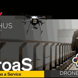 |
by Press on (#3WT6X)
Today, the Belgian drone and technology builder, DroneMatrix, launches its Drone-as-a-Service platform “DroaS†to the general public, laying the foundation stone for a new shared ecosystem. After years of experience in research and manufacture of drone devices, this DroaS platform is the glue that will connect companies and/or authorities with pilots and equipment. The platform […]
|
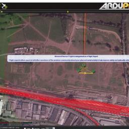 |
by Press on (#3WSB8)
Rupert Benbrook, Chief Evangelist at Altitude Angel Altitude Angel are proud to support the open-source Mission Planner (a popular ground-station controller) and ArduPilot community. For over a year now, we have been providing our class-leading airspace and ground hazard data to Mission Planner users so that they can make better informed and safer decisions about where to fly their […]
|
 |
by Rob Thompson on (#3WSBA)
Everyone enjoys a good ball game and there is no better way to experience this than to watch the action at a stadium live with 80k other like-minded fans rooting for the same team. When at a stadium have you ever asked yourself, what would happen if everyone wanted to leave at the same time? […]
|
 |
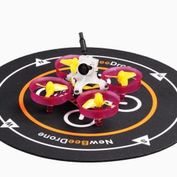
by Press on (#3WSBC)
Mantis Q Boasts Category Leading 33-Minute Flight Time, Easy-to-Use Flight Controls and Advanced Flight Modes CORONA, Calif. — Yuneec International, the world leader in electric aviation, today announced its all-new Mantis Q, the latest extension of Yuneec’s award-winning consumer lineup, is now available for pre-order in the United States. Mantis Q is an adventure ready […]
|
 |
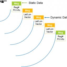
by Press on (#3WS7V)
Completing its first year of activity, SkyHopper by Mobilicom was sold to and successfully operated by customers in 14 different countries, and integrated with 45 drone manufacturers [August 14, 2018]: Mobilicom Ltd., a global mission-critical-communications solution provider, announces that its SkyHopper entity has now completed its first year of activity since it was launched on […]
|
 |
by Press on (#3WS7X)
RobotLAB, the leading educational robotics company, announces today that its award-winning online learning platform Engage! K12 offers entirely new and engaging lesson plans which use drones to teach coding, programming and math. Indiana University’s High School Survey of Student Engagement found that about 2 out of 3 students from the 81,000 surveyed, said they don’t see […]
|
 |
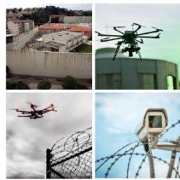
by Press on (#3WQAM)
Aerial security & surveillance operations are growing at a tremendous rate. In pursuit of a better ROI and effective use of resources, the businesses are now upgrading their security and surveillance systems. Efforts are being taken to make them mobile, automated and more efficient by using drones. According to Toptal, the commercial drone business represents the […]
|
 |
by Jonathan Rupprecht on (#3WPZX)
There are some great benefits to using a drone anti-collision light for recreational, public safety, and commercial operations. It increases safety and gives you greater flexibility in your operations. Remember to go over the list my tips and considerations before you buy anything because each drone anti-collision light has its own strengths and weaknesses. 1. […]
|
 |
by Press on (#3WNFY)
GREENSBORO – North Carolina has been “First in Flight†for almost 115 years. Today, “Next in Flight†might be more appropriate, thanks to the N.C. Department of Transportation’s Division of Aviation and its work with Unmanned Aircraft Systems (UAS, or ‘drones’). Over three days at Greensboro’s Grandover Resort & Conference Center, nearly 400 speakers, exhibitors and […]
|
 |
by Press on (#3WJYR)
Robot Aviation – a Norwegian company with offices in the US, Sweden & Poland has been developing drone technology for over 10 years. During 2018 we are presenting our complete line of systems, ranging from, SKYROBOT ™ FX10 a portable system, hand-launched within minutes, and able to stay airborne for up to 2 hours, carrying […]
|
 |
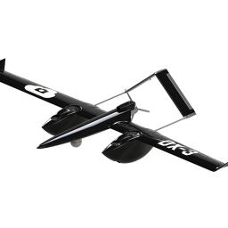
by Press on (#3WJSY)
The R2 aircraft started as a challenge to design, fly and operate a UAV with the true rhomboidal wing concept. This turned out to be a rather very demanding and complex design exercise but rewarded us with outstanding flying performances from the first flight of the first prototype. The advantages of the rhomboid wing, beside the […]
|
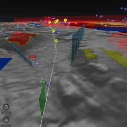 |
by Press on (#3WJT0)
Multiple Government Organizations evaluate new situational awareness platform for managing airspace and emergency response units during disaster scenarios Ottawa, CA: Kongsberg Geospatial Ltd., an Ottawa-based developer of geospatial visualization software, announced today the conclusion of the final trials of a new situational awareness system for emergency airspace management, in a project funded by Defence Research […]
|
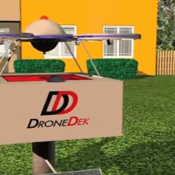 |
by Press on (#3WJ89)
DroneDek, mailbox of the future technology, has just been awarded a US Patent for last mile drone delivery. DroneDek is set to disrupt the parcel, package and mail delivery industry by leveraging several patent claims it was awarded that combine to make it a mailbox on steroids. DroneDek aims to solve drone delivery by offering […]
|
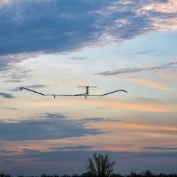 |
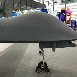
by Press on (#3WFYS)
Touch down after 25 days, 23 hours, and 57 minutes System capabilities demonstrated Maiden Flight objectives achieved Farnborough, 8 August 2018 – Airbus Defence and Space announced the successful landing of its first production aircraft of the Zephyr programme, the new Zephyr S HAPS (High Altitude Pseudo-Satellite). After taking off on 11th July in Arizona, […]
|
 |
by Press on (#3WFMQ)
UgCS, the world’s premier provider of mission planning software for unmanned aircraft systems (UAS), together with public safety and disaster response UAS experts Airborne Response®, have developed a comprehensive search capability for drones that will allow remote pilots to more effectively conduct search and rescue operations using the UgCS platform. The new software enhancements will […]
|
 |
by David Walters on (#3WFFF)
Drones and unmanned aircraft will be able to fly in the same airspace as manned aircraft under plans announced today by Blue Bear Systems Research Ltd and Cranfield University. The partners intend to create NBEC (the National Beyond visual line of sight Experimentation Corridor). The corridor will stretch across Bedfordshire from Blue Bear’s headquarters in Oakley to Cranfield […]
|
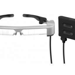 |
by Press on (#3WFYV)
Next-Generation Moverio Smart Glasses offer new flexibility for users connecting a wearable display to an existing device Designed for use with existing hardware devices, Epson, providers of the Moverio® augmented reality (AR) smart glasses platform, today launched the new Moverio BT-35E Smart Glasses. Featuring an interface unit with HDMI® and USB Type-C ports to connect to popular output […]
|
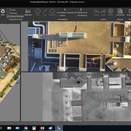 |
by Press on (#3WDN6)
Industrial SkyWorks is pleased to announce the official launch of BlueVu for digital inspections from drone-data. As one of the most trusted names in the industry, Industrial SkyWorks offers cutting-edge drone inspection solutions. Industrial Skyworks’ new BlueVu software relieves engineers and drone pilots from examining thousands of images and provides clear, accurate, professional looking reports. […]
|
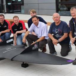 |
by Press on (#3WDN8)
The University of Central Lancashire (UCLan) has unveiled the world’s first graphene skinned plane at an internationally renowned air show. Juno, a three-and-a-half-metre wide graphene skinned aircraft, was revealed on the North West Aerospace Alliance (NWAA) stand as part of the ‘Futures Day’ at Farnborough Air Show 2018. The University’s aerospace engineering team has worked […]
|
 |
by Press on (#3WDNA)
You will be in charge with the prototyping and development of our electronic hardware and antennas. Also, you will test and validate our products over telecommunication or broadcast infrastructure. Requirements Previous experience (3 to 7 years) is required – applications with too much experience will not be considered Hands-on, with technical knowledge that can be […]
|
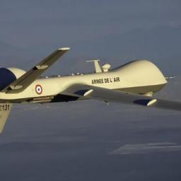 |
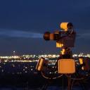
by Press on (#3WC6D)
The French Air Force operated two of its MQ-9 Reapers® simultaneously in support of France’s Bastille Day events, one over Paris and the second over Cognac, on July 14th. The “French Reapers,†Remotely Piloted Aircraft (RPA) built by General Atomics Aeronautical Systems, Inc. (GA-ASI), assisted French authorities by providing airborne surveillance over the national celebration. […]
|
 |
by Press on (#3WC6F)
Beginning on July 6, 2018, the US Government started imposing a 25% duty on a small subset of items and components that we import from China. These duties replace the existing duties on products, which previously already ranged between 0% and in excess of 12% depending on the item being imported. Rather than imposing a […]
|
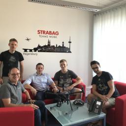 |
by Press on (#3WBC5)
STRABAG is a European tech company for construction services with about 73.000 employees worldwide. In early August, the first KlauPPK system was delivered to STRABAG‘s department “Digital Object Scanning and Dronesâ€, by Videographics Ingenieurgesellschaft mbH as a local representative of the KlauPPK in Europe, to evaluate the technology and compare it with few drone surveying […]
|
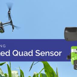 |
by Press on (#3WBC7)
Sentera’s Quad sensor is now available in an integrated gimbal-stabilized package for DJI Inspire and Matrice drones. Featuring four fully-customizable and individually-filtered focal plane arrays, the Gimbaled Quad sensor sets the standard for data accuracy and ease-of-use. Lock & Go™ technology provides simple, snap-in installation to the drone and actively stabilizes the optics to true nadir, […]
|
 |
by Press on (#3WB8R)
Terabee – creators of the TeraRanger Time-of-Flight distance sensors has released news of its new generation 360° solid-state LiDAR. With up to eight detection zones monitored simultaneously and at high-speeds, TeraRanger Tower Evo is lightweight, compact and ideal for collision avoidance on drones and robots. Terabee launched their first generation Tower in 2016, using […]
|
 |
by Press on (#3WB8T)
Hoverfly Technologies Inc., the world leader in tether-powered aerial drone systems, is pleased to announce Stephen (Steve) Walters has been promoted to president of Hoverfly. Steve will be responsible for all of Hoverfly’s business operations including R&D, engineering, manufacturing and product support. He will continue to lead the progress of Hoverfly’s LiveSky-branded tether-powered persistent aerial robots for surveillance […]
|
 |
by Press on (#3WB55)
Stadiums and other open-air venues are particularly vulnerable to the growing risk posed by the proliferation of consumer drones and Black Sage is addressing this issue by offering a new service. Commercially available drones have quite literally added a new dimension to security threats not only in war zones, but also at large public gatherings here […]
|
 |
by Press on (#3WB57)
Starting from July 6th, The US government imposed an additional tariff of 25% on many products imported from China. The products that are affected by this first round of tariff includes but not limited to ESCs, receivers, motors, batteries, and antennas. There is a second round of tariff that is currently under review which will […]
|
 |
by Patrick Egan on (#3W93Y)
We have already had to run up the white flag on the US made thousand-dollar UAV. But hold on to your hat, Mildred, we might be staring down the barrel of losing the whole damn drone circus. I know you’re probably thinking, “How the heck did this happen when all the K Street drone experts […]
|
 |
by Press on (#3W940)
DJI, the world’s leader in civilian drones and aerial imaging technology, today announced a brand partnership with LINE FRIENDS on its first characterized drone, making drone technology more fun and accessible to a wider audience. Featuring one of LINE FRIENDS’most popular characters Brown, the LINE FRIENDS (BROWN) l Spark drone is an easy-to-use, fun-to-fly mini camera drone that lifts […]
|